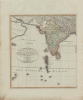
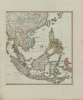
1804 Reinecke Map of Southeast Asia, India
EastIndies-reineckejcm-1804$600.00


Title
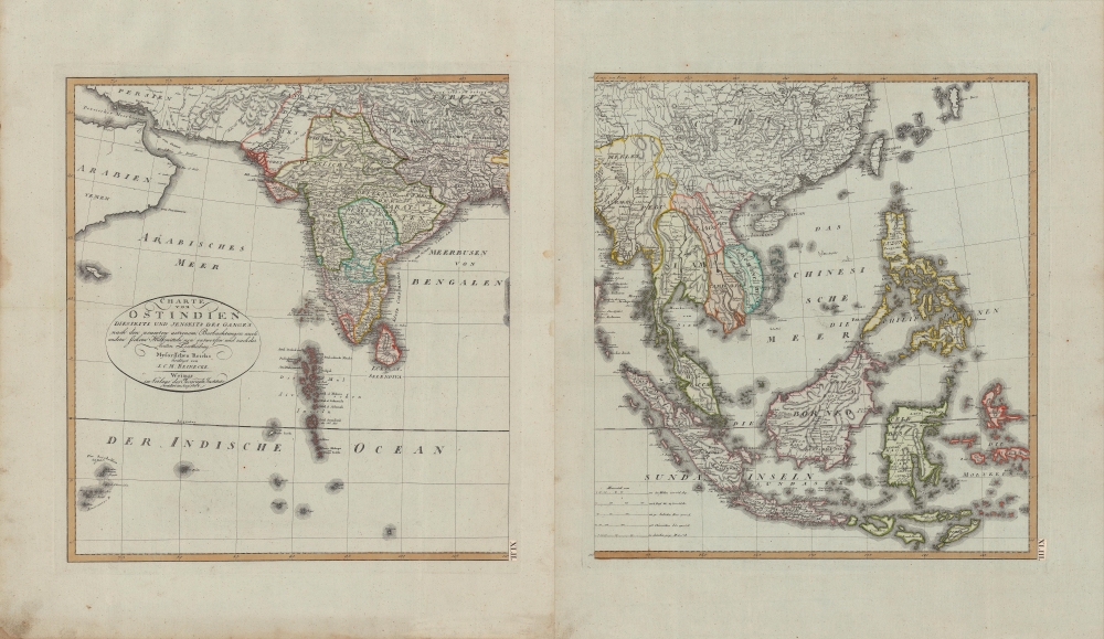
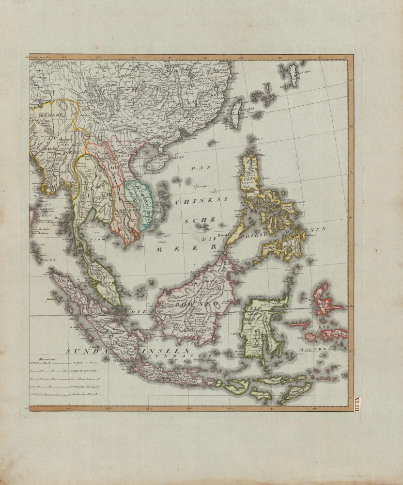
Charte von Ostindien diesseits und jenseits des Ganges.
1804 (dated) 19 x 37 in (48.26 x 93.98 cm) 1 : 12000000
1804 (dated) 19 x 37 in (48.26 x 93.98 cm) 1 : 12000000
Description
A beautiful 1804 German-language two-sheet map of the East Indies by J. C. M. Reinecke. It depicts the region as British power was ascendant, displacing both indigenous kingdoms and European rivals.
The full title mentions the recent division of Mysore, which came at the end of the Fourth Anglo-Mysore War (1798 - 1799), when the British effectively conquered the kingdom but maintained it as a princely state. One of the British officers in the conflict was Arthur Wellesley, who would go on to take a governorship over the just-conquered kingdom and then fight against the Maratha Confederacy before returning to Europe and achieving great triumphs in the Napoleonic Wars.
The conquest of Mysore reflected a broader policy of expansion by the British East India Company. Earlier content to limit itself to coastal trading posts, the company changed its approach in the mid-late 18th century and gained a series of victories against both indigenous kingdoms and European rivals that continued until most of South Asia was under direct or indirect British control.
Britain was also making inroads in Southeast Asia, gaining a post at Penang from the Sultan of Kedah in the late 18th century. The French Revolution and Napoleonic Wars provided greater opportunities, as much of Europe came under French occupation and was ruled by governments adversarial to Britain. When Holland was occupied by French forces, the Dutch East India Company was abolished. Soon after this map was published, Napoleon set up his brother as the King of Holland and the Dutch East Indies became a French colony.
With India as a base, the British East India Company progressively occupied trading posts throughout the East Indies, eventually capturing Batavia in August 1811. As governor, they appointed an impressive young officer who spoke Malay named Stamford Raffles, who would rule the British East Indies until they were returned to Holland in 1814. After spending a few years in England, during which time he wrote an acclaimed history of Java, Raffles returned to Southeast Asia, where he came to be seen as one of the most capable agents of the company. Operating from the company's trading post at Bencoolen, Raffles played a central role in establishing a British colony at Singapore and more broadly in ensuring British dominance over the Straits of Malacca.
A Closer Look
Adopting a wide area of coverage, the map extends from Persia through the Philippines and the Indonesian Archipelago, taking in the Indian subcontinent and mainland Southeast Asia. Reflecting the array of cultures and kingdoms, the map includes five scales; in addition to maritime miles, English, Indian, Chinese, and German units of measure are indicated.The full title mentions the recent division of Mysore, which came at the end of the Fourth Anglo-Mysore War (1798 - 1799), when the British effectively conquered the kingdom but maintained it as a princely state. One of the British officers in the conflict was Arthur Wellesley, who would go on to take a governorship over the just-conquered kingdom and then fight against the Maratha Confederacy before returning to Europe and achieving great triumphs in the Napoleonic Wars.
The conquest of Mysore reflected a broader policy of expansion by the British East India Company. Earlier content to limit itself to coastal trading posts, the company changed its approach in the mid-late 18th century and gained a series of victories against both indigenous kingdoms and European rivals that continued until most of South Asia was under direct or indirect British control.
Britain was also making inroads in Southeast Asia, gaining a post at Penang from the Sultan of Kedah in the late 18th century. The French Revolution and Napoleonic Wars provided greater opportunities, as much of Europe came under French occupation and was ruled by governments adversarial to Britain. When Holland was occupied by French forces, the Dutch East India Company was abolished. Soon after this map was published, Napoleon set up his brother as the King of Holland and the Dutch East Indies became a French colony.
With India as a base, the British East India Company progressively occupied trading posts throughout the East Indies, eventually capturing Batavia in August 1811. As governor, they appointed an impressive young officer who spoke Malay named Stamford Raffles, who would rule the British East Indies until they were returned to Holland in 1814. After spending a few years in England, during which time he wrote an acclaimed history of Java, Raffles returned to Southeast Asia, where he came to be seen as one of the most capable agents of the company. Operating from the company's trading post at Bencoolen, Raffles played a central role in establishing a British colony at Singapore and more broadly in ensuring British dominance over the Straits of Malacca.
Publication History and Census
This map is attributed to Johann Christoph Matthias Reinecke and was published by the Geographische Institut Weimar in 1804, the same year the Institut was founded. It is listed among the holdings of seven institutions in the OCLC, most of which are in Germany. Editions of this map from 1800, 1801, 1817, 1820, and 1822 also appear in institutional catalogs, but in any edition are quite rare.CartographerS
Johann Christoph Matthias Reinecke (October 9, 1770 - November 7, 1818) was a German polymath, known for his contributions to cartography and paleontology. A polymath, he wrote poems, novels and songs, understood eight languages and produced works in botany, zoology and geography, which he illustrated himself and for which he drew maps. He also designed and drew 22 maps for the Geographisches Institut zu Weimar's 'Allgemeiner Hand-Atlas der Ganzen Erde'. As a paleontologist, he described 37 new ammonite species of the Jurassic and produced oa 400 page catalogue of the fossil collection of prince Franz Friedrich Anton of Saxonia Coburg Saalfeld (1750-1806). More by this mapmaker...
Geographisches Institut, Weimar (fl. 1804 - c. 1903) was a German map and globe publishing house and geographical research institute based in Weimar. The organization primarily focused on republishing and improving upon the works of earlier cartographers, including Kitchin, Jefferys, Carey, and others. In general, its publications are known for their fine engraving, attention to detail, historical accuracy, and overall high quality. The firm was founded in 1804 by Friedrich Justin Bertuch (???? - c. 1845) and, on his death, passed to his son Robert Froreip (???? - 1855), then to Louis Denicks of Luneberg, then in 1859 to Voigt & Günther, in 1883 to F. Arnd, from 1890 - 1893 to Julius Kettler, and in 1903 to Max Wedekind. During the institute's height in the early 19th century, most of its cartographic publication was overseen by Carl Ferdinand Weiland (1782 - 1847). The firm also employed the cartographers Franz Xaver von Zach, Adam Christian Gaspari, Heinrich Kiepert, Karl (or Carl) and Adolf Graef, Julius Kettler, Carl Riemer and Karl Christian Bruhns. Weimar was a logical place for a collective like the Geographisches Institut to arise; it was a cultural mecca in the German-speaking world in the late 18th and 19th centuries because of its liberal atmosphere and associations with figures like Schiller, Herder, and, above all, Goethe, who spent most of his adult life in the city. Learn More...
Condition
Very good. Some foxing and discoloration in the margins.
References
OCLC 922020989, 893476852, 1071154932, 843376863, 69440590.