1774 Cook Harbor Maps of the Endeavour River and Botany Bay in Australia
EndeavourBotany-cook-1774$450.00

Title
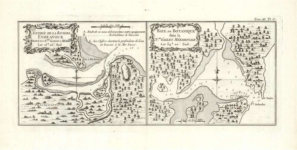
Entreé de la Riviere Endeavour dans la Nle. Galles Meridle./ Baye de Botanique dans la Nle. Galles Meridle.
1774 (undated) 5.5 x 13 in (13.97 x 33.02 cm)
1774 (undated) 5.5 x 13 in (13.97 x 33.02 cm)
Description
This is the 1774 first French edition of the first printed map of the mouth of the Endeavor River and the harbor of Botany Bay, discovered and named by the legendary navigator James Cook during his first voyage aboard the H.M.S. Endeavor. Both of these harbor charts are oriented to the north; they show depth soundings, the location of fresh water, and sandbars; topography and vegetation is shown pictorially
Amongst the depth soundings is Endeavour's anchorage off the shore of Point Sutherland, also noted here. This headland was named after crewman Forby Sutherland, who died April 30 1770: the first British subject to die in Australia and the first European to be buried in New South Wales.
Botany Bay
The right-hand chart on this sheet focuses on Botany Bay. This New South Wales harbor has a long human presence - Archaeological evidence shows Aboriginal settlement dating back 5,000 years: Lieutenant James Cook would encounter the place on April 29, 1770, as HMS Endeavour sailed up the east coast of Australia. Cook's landing here was the first British landfall in Australia, representing the beginning of Britain's colonization of the continent. Cook's initial name for the place was 'Stingrays Harbour,' referencing the many such fish they caught there. After further consideration, Cook instead - in honor of his ship's botanists and the wealth of plants they found here - chose to name the harbor 'Botany Bay' in his published logbooks.Amongst the depth soundings is Endeavour's anchorage off the shore of Point Sutherland, also noted here. This headland was named after crewman Forby Sutherland, who died April 30 1770: the first British subject to die in Australia and the first European to be buried in New South Wales.
Endeavour River
This chart of the mouth of the Endeavour river reveal's Cook's haven on the Australian coast after his ship ran aground and nearly sank on June 10, 1770. After remaining aground 23 hours, Cook and crew were forced to throw overboard some fifty tons of cargo and supplies in order to float Endeavour off the rocks. Endeavour was finally able to limp to shore and beach the ship for repairs at the mouth of the Endeavour River, the subject of this chart. A three-point legend shows the locations of A) the beach where the crew disembarked and unloaded their remaining kit; B) the shallows upon which Endeavour was careened for repair; and C) the depth of the river mouth at low tide.Publication History and Census
This map was engraved by Robert Bénard for the 1774 French edition of James Hawkesworth's 1773 account of Cook's voyages. It follows the 1772-1773 English edition engraved by William Whitchurch and published in 1773. While Hawkesworth's book is well represented in institutional collections, this separate map is catalogued only by the National Library of Australia, the Sachsische Landesbibliothek, and the Hocken Collection at the University of Otago.CartographerS
Captain James Cook (7 November 1728 - 14 February 1779) is a seminal figure in the history of cartography for which we can offer only a cursory treatment here. Cook began sailing as a teenager in the British Merchant Navy before joining the Royal Navy in 1755. He was posted in America for a time where he worked Samuel Holland, William Bligh, and others in the mapping of the St. Lawrence River and Newfoundland. In 1766 Cook was commissioned to explore the Pacific and given a Captaincy with command of the Endeavour. What followed were three historic voyages of discovery, the highlights of which include the first European contact with eastern Australia, the discovery of the Hawaiian Islands (among many other Polynesian groups), the first circumnavigation of New Zealand, some of the first sightings of Antarctica, the first accurate mapping of the Pacific Northwest, and ultimately his own untimely death at the hands of angry Hawaiians in 1779. The influence of Cook work on the mapping and exploration of the Pacific cannot be understated. More by this mapmaker...
John Hawkesworth (c. 1715 - November 16, 1773) was an English born writer and editor born London. Hawkesworth, who is said to have been self educated, succeeded Samuel Johnson as the parliamentary debate compiler for "Gentleman's Magazine". He was a deeply religious and moral map who brilliant defense of morality earned him an LL. D degree from the Archbishop of Canterbury. Hawkesworth went on to publish a series of scholarly books and essays including a 12 volume edition of Jonathan Swift's work. In 1772 Hawkesworth was commissioned by the Admiralty to compile and edit James Cook's journals. The resultant work An Account of the Voyages undertaken ... for making discoveries in the Southern Hemisphere was one of the first ethnographic account of the South Seas and was widely published in England and abroad. Though highly influential, Hawkesworth's work received heavy criticism from scholars who claim that he liberally altered much of the text in the name of morality. Learn More...
Robert Bénard (1734 - c. 1785) was a French engraver. Born in Paris, Bénard is best known for supplying a significant number of plates (at least 1,800) for the Encyclopédie published by Diderot and Alembert. He also is remembered for his work with the Académie des Sciences, most notably the Descriptions des Arts et Métiers Learn More...
Source
Hawkesworth, J., Relation des voyages entrepris par ordre de Sa Majeste britannique, actuellement regnante; pour faire des decouvertes dans l'hemisphere meridional ..., (Paris: Chez Saillant et Nyon ... Chez Panckoucke, Hotel de Thou) 1774.
Condition
Very good condition. Two mended wormholes at centerfold outside printed image, else excellent condition with full margins.
References
OCLC 154686779.