This item has been sold, but you can get on the Waitlist to be notified if another example becomes available, or purchase a digital scan.
1873 Weller Map of the Faroe Islands
FaroeIslands-weller-1873$125.00

Title
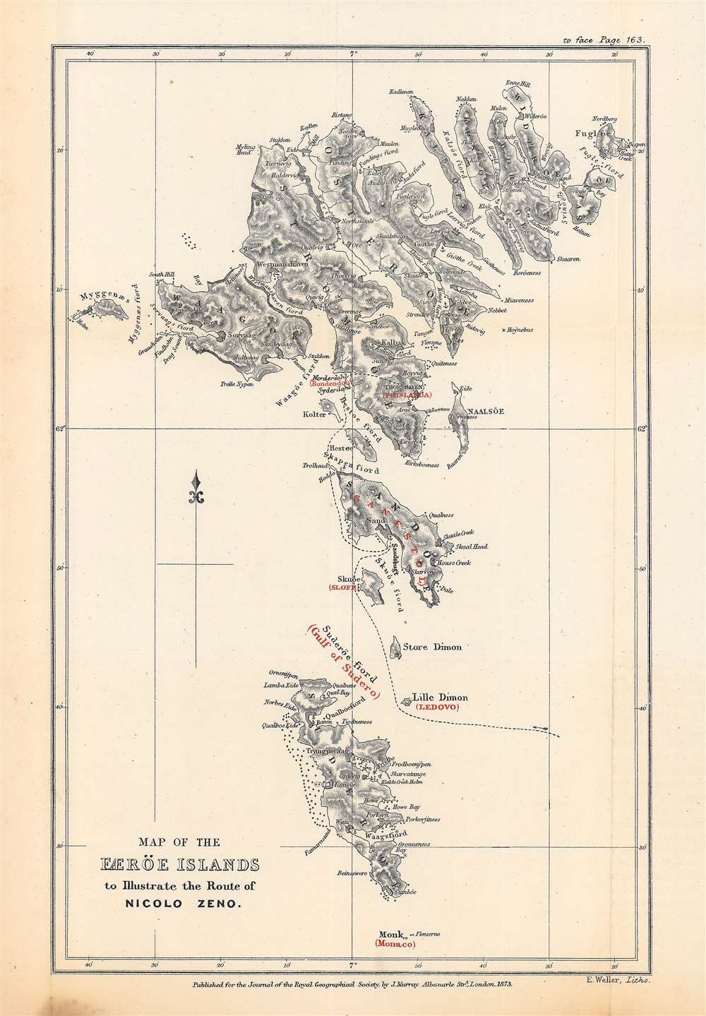
Map of the Færöe Islands, to Illustrate the Route of Nicolo Zeno.
1873 (dated) 10 x 6.5 in (25.4 x 16.51 cm) 1 : 475000
1873 (dated) 10 x 6.5 in (25.4 x 16.51 cm) 1 : 475000
Description
This is Edward Weller's map of the Faroe Islands, published in 1873 in the Journal of the Royal Geographical Society, outlining the presumed route of Nicolò Zeno, a Venetian mariner who may have visited the islands in the late 14th century. The potential travels of Nicolò and his brother Antonio, including a possible discovery of the New World a century before Columbus, have been one of the most enduring debates in the history of cartography.
More problematic, Nicolò Zeno the Younger's entire account is highly suspect and is now generally considered to have been a hoax. The map and letters suggested that not only did the Zeno brothers land at Iceland and Greenland, but may have reached Labrador (an island they called 'Estotiland'), beating Columbus to the New World by a century. It is believed that Nicolò the Younger concocted the sources using several contemporary (1550s) maps with the intention of claiming a Venetian discovery of the New World with his own ancestors as the heroes. While the Zenos were a well-established naval family in Venice and the brothers likely were frequent travelers on the seas, there is no corroborating evidence that they indeed plied the North Atlantic in the years claimed by Nicolò the Younger. In fact, the limited evidence that does exist suggests that they were in Venice during the period of their purported voyage.
Nonetheless, even after the non-existent islands were removed from maps of the North Atlantic, the compelling tale of the Zenos led to cartographers to occasionally craft maps of the 'phantom islands,' or to attempt to chart their voyage based on the text in their letters, as is the case here.
Six years later, the Journal of the Royal Geographical Society hosted competing articles by Admiral Irminger and R.H. Major, respectively titled 'Zeno's Frislanda is Iceland and Not the Faeroes' and 'Zeno's Frislanda is Not Iceland, but the Faroes: an Answer to Admiral Irminger.' While Major disputed the identity of Frisland, he did believe that the Zeno brothers actually undertook a North Atlantic voyage (or voyages) and likely discovered the New World, though subsequent research casts serious doubt on both these claims.
The present map is not known to be cataloged independently in the holdings of any institution and has no known history on the market, while both the 1873 edition of the Journal of the Royal Geographical Society and Major's booklet on the Zeno Voyages are present in holdings of major research institutions.
A Closer Look
Weller combines an up-to-date (1873) map and chart of the Faroe Islands with information from Zeno's letters describing travels in the North Atlantic. In black are the islands, coasts, and placenames (including fjords) of the islands, along with hachures to show elevation and symbols to highlight coastal hazards. A dashed black line traces the route of Zeno and text in red indicates the names used in Zeno's letter for islands and bays with their most likely corresponding locations on the Faroe Islands.The 'Zeno Map'
The purported travels of the Venetian brothers Nicolò and Antonio Zeno in the late 14th century have been the source of a long-running debate in the history of cartography. In 1558, Nicolò Zeno the Younger, a descendant of the brothers, claimed to have found a map and letters regarding a voyage of his ancestors to the North Atlantic. This 'Zeno Map' became an influential source of information on the hitherto poorly-mapped region and was incorporated into maps well into the 17th century. However, later explorations found that some of the North Atlantic islands on the map, most famously Frisland (or Frislanda), simply did not exist. It is possible that the brothers had confused the Faroe Islands for a single large island which they gave this name, but some editions of the Zeno Map contain both the Faroe Islands and Frisland.More problematic, Nicolò Zeno the Younger's entire account is highly suspect and is now generally considered to have been a hoax. The map and letters suggested that not only did the Zeno brothers land at Iceland and Greenland, but may have reached Labrador (an island they called 'Estotiland'), beating Columbus to the New World by a century. It is believed that Nicolò the Younger concocted the sources using several contemporary (1550s) maps with the intention of claiming a Venetian discovery of the New World with his own ancestors as the heroes. While the Zenos were a well-established naval family in Venice and the brothers likely were frequent travelers on the seas, there is no corroborating evidence that they indeed plied the North Atlantic in the years claimed by Nicolò the Younger. In fact, the limited evidence that does exist suggests that they were in Venice during the period of their purported voyage.
Nonetheless, even after the non-existent islands were removed from maps of the North Atlantic, the compelling tale of the Zenos led to cartographers to occasionally craft maps of the 'phantom islands,' or to attempt to chart their voyage based on the text in their letters, as is the case here.
Publication History and Census
This map was drafted by Edward Weller and published by the firm John Murray. It appeared in 1873 in Volume 43 of the Journal of the Royal Geographical Society to accompany an article by R. H. Major, an editor of the Journal of the Royal Geographical Society and Secretary of the Royal Geographical Society, titled 'The site of the lost Colony of Greenland determined, and Pre-Columbian discoveries of America confirmed from 14th Century Documents.' The article summarizes a short book by Major (published by the Hakluyt Society) titled The Voyages of the Venetian Brothers, Nicolò and Antonio Zeno, to the Northern Seas in the XIVth Century.. Both Major's booklet and the journal included the present map along with a reproduction of the Zeno Map of 1558 and another Weller lithograph titled 'Sketch map of the countries referred to in the Zeno Narrative.'Six years later, the Journal of the Royal Geographical Society hosted competing articles by Admiral Irminger and R.H. Major, respectively titled 'Zeno's Frislanda is Iceland and Not the Faeroes' and 'Zeno's Frislanda is Not Iceland, but the Faroes: an Answer to Admiral Irminger.' While Major disputed the identity of Frisland, he did believe that the Zeno brothers actually undertook a North Atlantic voyage (or voyages) and likely discovered the New World, though subsequent research casts serious doubt on both these claims.
The present map is not known to be cataloged independently in the holdings of any institution and has no known history on the market, while both the 1873 edition of the Journal of the Royal Geographical Society and Major's booklet on the Zeno Voyages are present in holdings of major research institutions.
CartographerS
Edward Weller (July 1, 1819 - 1884) was a cartographer and engraver based in London. Weller was a nephew of another well-known map publisher Sidney Hall (1788 - 1831), who gave him 50 Pounds to pay his apprenticeship fees. He engraved for many prominent mapmakers and was active enough in the community to be recommended for membership to the Royal Geographical Society in 1851 on the recommendation of John Arrowsmith, among others. He eventually inherited the Sidney Hall map business which led him to follow Arrowsmith as the unofficial geographer to the Royal Geographical Society. Weller was among the first map printers in London to embrace lithography. His best known work appears in Cassell's Weekly Dispatch Atlas, published in monthly segments for subscribers of the 'Weekly Dispatch' newspaper. This collection of maps eventually grew to include much of the known world. Published in various editions from 1855 through the early 1880s. Weller died in May of 1884, leaving behind a successful business and an unhappy widow. His son, Francis Sidney Weller (1849 - 1910), followed in his father's footsteps and continued the family map business. The atlas Mackenzie's Comprehensive Gazetteer of England and Wales was published in 1894 and bore F. S. Weller's signature on the maps. More by this mapmaker...
John F. Murphy (fl. c. 1880 - 1920) was a news agent and businessman active in the Boston area during the late 19th century and early 20th century. Murphy managed numerous successful businesses in Boston and the surrounding area, including a number of news stands in railroad stations across the state. He is best known for his publication "Birds Eye Views of Boston Harbor", a tourist oriented map series focusing on Boston Harbor, Cape Cod, the South Shore and Provincetown. Learn More...
Royal Geographical Society (fl. 1830 - present) is a British Society established in 1830 to promote geographical science and exploration. Originally titled the "Geographical Society of London", the RGS received its royal charter from Queen Victoria in 1859 shortly after absorbing several similar but more regional societies including the African Association, the Raleigh Club and the Palestine Association. The RGS sponsored many of the most important and exciting voyages of exploration ever undertaken, including the exploration of Charles Darwin, David Livingstone, Robert Falcon Scott, Richard F. Burton, John Speke, George Hayward, H. M Stanley, Ernest Shackleton and Sir Edmond Hillary. Today, the RGS remains a leading global sponsor of geographical and scientific studies. The Society is based in Lowther Lodge, South Kensington, London. Learn More...
Condition
Good. Even toning in the margins. One noticeable area of discoloration at bottom-left margin.