Digital Image: 1885 J. H. Brown View of Union Attack on Fort Sumter, U.S. Civil War
FederalIronclads-crane-1885_d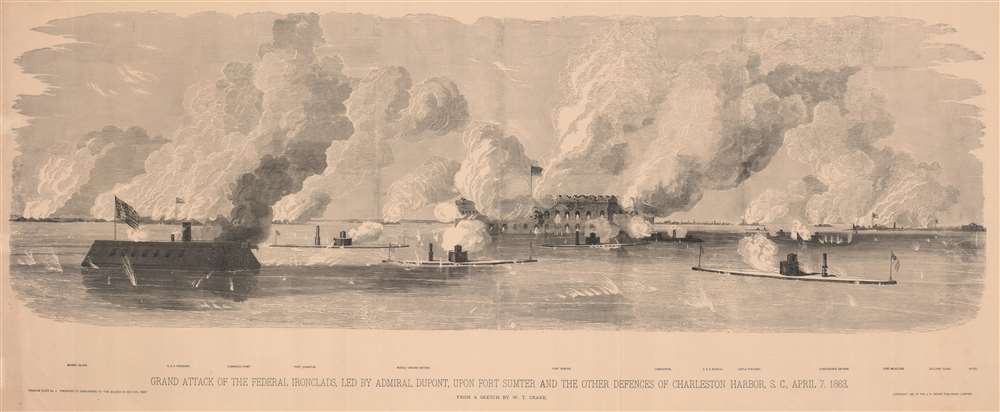


Title
Grand Attack of the Federal Ironclads, led by Admiral Dupont, upon Fort Sumter and the other defences of Charleston Harbor, S. C., April 7, 1863.
1885 (dated) 17.25 x 43 in (43.815 x 109.22 cm)
1885 (dated) 17.25 x 43 in (43.815 x 109.22 cm)
Description
FOR THE ORIGINAL ANTIQUE MAP, WITH HISTORICAL ANALYSIS, CLICK HERE.
Digital Map Information
Geographicus maintains an archive of high-resolution rare map scans. We scan our maps at 300 DPI or higher, with newer images being 600 DPI, (either TIFF or JPEG, depending on when the scan was done) which is most cases in suitable for enlargement and printing.
Delivery
Once you purchase our digital scan service, you will receive a download link via email - usually within seconds. Digital orders are delivered as ZIP files, an industry standard file compression protocol that any computer should be able to unpack. Some of our files are very large, and can take some time to download. Most files are saved into your computer's 'Downloads' folder. All delivery is electronic. No physical product is shipped.
Credit and Scope of Use
You can use your digial image any way you want! Our digital images are unrestricted by copyright and can be used, modified, and published freely. The textual description that accompanies the original antique map is not included in the sale of digital images and remains protected by copyright. That said, we put significant care and effort into scanning and editing these maps, and we’d appreciate a credit when possible. Should you wish to credit us, please use the following credit line:
Courtesy of Geographicus Rare Antique Maps (https://www.geographicus.com).
How Large Can I Print?
In general, at 300 DPI, you should at least be able to double the size of the actual image, more so with our 600 DPI images. So, if the original was 10 x 12 inches, you can print at 20 x 24 inches, without quality loss. If your display requirements can accommodate some loss in image quality, you can make it even larger. That being said, no quality of scan will allow you to blow up at 10 x 12 inch map to wall size without significant quality loss. For more information, it is best consult a printer or reprographics specialist.
Refunds
If the high resolution image you ordered is unavailable, we will fully refund your purchase. Otherwise, digital images scans are a service, not a tangible product, and cannot be returned or refunded once the download link is used.
Cartographer
William T. Crane (1832 - July 14, 1865) was an American artist. Born in Portsmouth, New Hampshire, Crane was interested in drawing from an early age. During the U.S. Civil, War, Crane worked as a 'Special Artist' for Frank Leslie's Illustrated Newspaper (Leslie's) and created drawings and sketches of battles and other Civil War-related scenes for the newspaper. He produced a prodigious volume of work while following the Union Army through North Carolina, South Carolina, Georgia, and Florida, most of which were 'on-scene war drawings' which were then turned into line engravings for Leslie's. His work was also published in the two-volume special edition pictorial history of the American Civil War, The Soldier in Our Civil War, which contained many Leslie's illustrations. Crane died at the National Hotel in Washington, D.C., on July 14, 1865, of throat disease. He was in D.C. covering current events, including drawing sketches of the execution of the conspirators that murdered President Abraham Lincoln. Leslie's obituary for Crane praised his ability to draw truthful sketches, many of which captured important events of the war. The obituary also lauded his devotion to his parents and his brother. Very little else is known about Crane's short life. More by this mapmaker...
References
LCCN 2018756272. OCLC 489195996.