This item has been sold, but you can get on the Waitlist to be notified if another example becomes available, or purchase a digital scan.
1591 De Bry and Le Moyne Map of Florida and Cuba
Florida-debry-1591$5,000.00

Title
Floridae Americae Provinciae Recens & Exactissima Descriptio Auctore Iacobo Le Moyne cui Cognomen de Morgues, qui Laudonierum …
1591 (undated) 14 x 18 in (35.56 x 45.72 cm)
1591 (undated) 14 x 18 in (35.56 x 45.72 cm)
Description
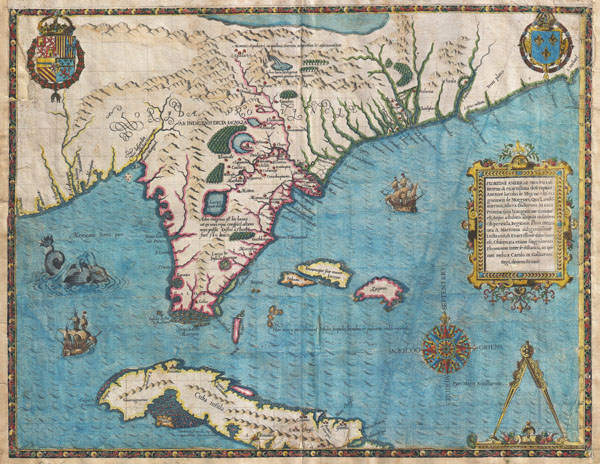
…the most remarkable and important map, which has been preserved from the sixteenth century maps, of that part of the East Coast which lies between Cape Hatteras and Cape Florida … the first French map to show Florida … considered the most important map of Florida. - Johns Matthews BaxterA map of extraordinary rarity and seminal importance, this is one of the earliest and most influential maps of the American southeast ever published. Drawn by the French artist Jacques Le Moyne de Morgues c. 1565 and published by Theodore de Bry in 1591, this magnificent map details the Florida peninsula and Carolina coast from Cuba to the Bahamas, to 'Prom Terra flag' or, as it is known today, Cape Lookout near Beaufort, North Carolina.
The fascinating story of this map begins with the ambitions of the influential Huguenot Admiral Gaspard de Coligny. De Coligny, desirous of a French foothold on the American mainland sent the talented navigator Jean Ribaut to establish a colony. In 1562 Ribaut landed near the mouth of the St. John River, which he named F. Maij after the month in which he landed. Ribaut and his crew then sailed north along the coast until they discovered a large bay which they named Port Royal. Here they landed and established Charlefort after King Charles IX of France. This is the first mention of Port Royal on any map and is, along with Prom. Canaueral (Cape Canaveral), the only two sites in Florida to retain their French names through the following centuries of Spanish and English dominance.
Having successfully established Charlefort, Ribaut returned to France to bring additional settlers and supplies. There he discovered his homeland to be in the midst of a religious war between the Catholic house of Valois and the Huegonot house of Bourbon, with whom he was associated. The conflict took Ribaut to England where involvement in a political plot saw him imprisoned.
Meanwhile in less than a year the colony of Charlefort, beset by famine, an aggressive indigenous population, and a lack of supplies mutinied. Constructing a small adhoc sailing craft, the fifty or so mutinous settlers attempted to return to France. Lacking a proper navigator or notable sailing skills, the settlers would surely have died at sea had they not been picked up by a passing English ship.
By 1564, a tentative peace had been established in France and, not one to see his ambitions thwarted, Admiral De Coligny planed a second expedition to the New World. With Ribaut imprisoned in England, De Coligny chose an under commander on the first voyage, Rene de Laudonniere, to lead the second expedition. Laudonniere landed and set up a settlement along the F. Maij (River May or St. John's River) which he named Carolina. This second expedition also included the prominent French artist Jacques Le Moyne, who was commissioned to record and map as much of the region as possible
Back in Europe, Ribaut had been released from prison and Coligny sent him, along with several ships and some 200 soldiers, to take command of the Carolina settlement. By this time the Catholic King of Spain, having heard about the French colony, dispatched the newly appointed Governor of Florida, Don Pedro Menéndez de Avilés, with orders to remove the 'Heretic French.' After a brief skirmish with Ribaut's ships, Menéndez de Avilés sailed south and established St. Augustine, the first permanent European settlement on the North American mainland. From St. Augustine, Menéndez de Avilés marched his troops overland to Carolina where they destroyed the fort and, in a shocking display of violence, slaughtered most of the settlers, including Ribuat.
Laudonniere, Le Moyne, a few others managed to escape through the surrounding swamps and forests. Catching an English ship, the small group eventually made it to London where Le Moyne ultimately settled. Given the hardships of his voyage back to Europe, it is unlikely that any of Le Moyne's original manuscript maps or sketches survived. Most scholars assume that Le Moyne must have reproduced his material from memory in London.
About twenty years later, Jacques De Bry was in the process of assembling his multivolume Grands Voyages. De Bry traveled to London in 1587 and attempted without success to purchase Le Moyne's material. It was not until Le Moyne's death one year later that his widow sold De Bry her deceased husband's journals and papers. De Bry finally edited and published Le Moyne's account and map in 1591.
The map itself is a remarkable piece of work incorporating information garnered from resident American Indian tribes as well as first hand observations by Le Moyne's and his fellow settlers. Florida is drawn in a V shape with the bottom lopped off. Most of Le Moyne's latitudinal calculations are correct, but erroneous calculations of longitude, common at the time, lead to an incorrect eastward extension of the Carolina and Virginia coastlines. It is Le Moyne's misfortune that this error proved to be one of his most enduring cartographic legacies. This map was used by Hondius as the basis for his 1606 Mercator map of the same region and also influenced their mapping of Virginia. Mercator's influence saw the error perpetuated until about 1640 when Blaeu partially corrected it in his own Virginiae map.
The interior is full of curious though often erroneous elements. The southernmost lake, Lactus Insula Sarrope, most likely depicts Lake Okeechobee. Further north a significantly larger lake is labeled Lacus Aquae Dulces (Sweet Water Lake) and shown to be the source of the St. John or May River. The note below this lake suggests that it is so large that its far shore could not be seen. Most scholars suggest that this must have been intended to represent Lake George or one of the other large lakes in central Florida. However, as with Le Moyne's longitudinal errors, the idea of this lake was taken up by Hondius and Mercator who, in their 1606 map, invert the course of the May River thus situating this lake far to the northwest in Appalachia. Consequently, 'through mutations of location and size [this] became the great inland lake of the Southeast' (Cumming, 478) – an apocryphal cartographic element that would remain one of Le Moyne's most tenacious legacies.
One of the most curious and striking elements on this map is a further lake depicted far to the north and fed by an enormous waterfall. Many suggest that this must have been based on native legends of Niagara Falls. A note near the lake and falls reads that the natives of this land find grains of silver in this lake. North of this is another gigantic body of water that is mostly likely Verrazano's Sea. Verrazano erroneously postulated that the Pacific was accessible via an enormous inland sea separated from the Atlantic by only a narrow isthmus near the Grand Banks of North Carolina. However, if we accept that the gigantic waterfall shown is in fact Niagara Falls; might we not also assume that this is the first cartographic representation, however vague, of the Great Lakes, or more specifically, Lake Ontario?
This map also names numerous American Indian villages and tribes throughout. One in particular, located near the mysterious waterfall is named Apalatci, with a note above it that reads 'Montes Apalactci' making this the first cartographic representation of the Appalachian Mountains.
The Bahamas as well as Bimini are indicated, though only vaguely. This map also shows Tampa Bay and attempts to show the Florida Keys and the Everglades. Northern Cuba is well mapped with several major cities including Havana. The seas are decorated with two sailing ships, a wonderful double spouted sea monster, a compass rose, and a navigational tool. Armorial crests of France decorate the upper right and left quadrants. At right, center, there is a large title area with descriptive text. The whole is surrounded by a decorative border with a curious sea monster motif.
Published by Theodore De Bry in volume two of his 1591 Grand Voyages to illustrate Jacques Le Moyne de Morgues' Brevis Narratio Eorum Quae in Florida Americae Provnicia .
CartographerS
Théodore de Bry (1528 - March 27, 1598) was an important publisher active in the mid to late 16th century. De Bry was born in 1528 in Liege, then a Prince-Bishopric and thus independent of neighboring nations. The De Bry family were accomplished jewelers and copperplate engravers and, following the family tradition, Theodore apprenticed in these fields under his grandfather Thiry de Bry senior (? - 1528), and later under his father, Thiry de Bry junior (1495 - 1590). To avoid growing religious strife in the region Théodore de Bry left Liege for the more tolerant Strasburg. Shortly afterwards, in 1577, he moved again to Antwerp and, in 1580 to London, where he became well known for his engraving skills. It was either in Antwerp or in London that De Bry befriended the English publisher and editor of traveler's tales Richard Hakluyt. Inspired by Hakluyt's work, De Bry began to collect travelers' tales, particularly of voyages to New World. His most prominent acquisition was most likely the letters and papers of the French painter and mapmaker Jacques Le Moyne de Morgues discussing a disastrous attempt by French Huguenots to colonize parts of Florida. Around, 1588 De Bry moved to Frankfurt where he began his own publishing firm. Among De Bry's earliest and most prominent publications are his Grands Voyages, a multivolume compilation of travelers' tales that included the work of Le Moyne as well as some of the earliest published depictions of the North American mainland. The firm also published various other works including an important account of early English attempts to colonize Virginia with illustrations by John White. De Bry died in Frankfurt on March 27, 1598, having never left the shores of Europe, though his name was associated throughout Europe with tales of travel and adventure. Théodore de Bry was succeeded by his son Jean-Théodore (1560 - 1623) who continued the publishing firm until his own death in 1623. More by this mapmaker...
Jacques Le Moyne de Morgues (c. 1533 - 1588) was a French Huguenot painter born in Dieppe, France in 1533. Little is known of Le Moyne's early life; however, as Dieppe was at the time a center for both painting and cartography, it might be assumed that Le Moyne trained in the city of his birth. It is likely that le Moyne was employed at the court of King Charles IX where he most likely first met the Huguenot Admiral Gaspard de Coligny. Coligny commissioned Le Moyne to accompany his expedition to colonize Florida, where he was to record and map as much of the New World as possible. Under the command of Jean Ribault and Rene Laudonniere from 1562 - 1564, Le Moyne created a series of illustrations and maps depicting indigenous plants, peoples of Florida. This important work, eventually published by Theodore de Bry, is considered to be among first European images of the North American mainland. His important map, Floridae Americase Provinicae is considered to be one of, if not the, most important map of Florida ever published. Nonetheless, contemporary scholars have put Le Moyne's work under intense scrutiny as no original examples of his work remain. Considering the fate of the disastrous Huguenot colony in Florida, it is understandable that little if any of Le Moyne's original work survived and, consequently, it is a safe bet that most of his work was reproduced from memory in London. More likely than not, inconsistencies between Le Moyne's representations of indigenous American peoples, flora and fauna, and actual fact can be attributed to lapses in memory. Following his return returned from the New World, Le Moyne settled in London where he became a prominent botanical illustrator, at times working with such notable personages as Sr. Walter Raleigh. His work expresses typical Calvinist attention to detail and absence of ornamentation. Le Moyne died in London in 1588 having never seen his own work published. It was not until after his death when Le Moyne's widow sold his papers to the Frankfurt publisher Theodore de Bry, that le Moyne's important illustrations of early Florida were finally published. Le Moyne's sole surviving watercolor is held in the collections of the New York Public Library. Learn More...
Source
Le Moyne de Morgues, J., Brevis Narratio Eorum Quae in Florida Americae Provicia, in De Bry, J., Grands Voyages, part II, 1591 edition.
Condition
Very good condition. Professional restoration along bottom margin (in manuscript), lower right corner, and upper left corner. Bottom, left and right margin extended. Original centerfold exhibits minor wear.
References
Burden, P.D., The Mapping of North America: A List of Printed Maps, 1511 - 1670, vol. 2, pl. 79. Cumming, W. P., The Southeast in Early Maps, 14. Cumming, W. P., The Discovery of North America. p.174-5. Cumming, W. P., 'Geographical Misconceptions of the Southeast in the Cartography of the Seventeenth and Eighteenth Centuries', The Journal of Southern History, vol. 4, no. 4 (Nov, 1938), p. 476-491. Goss, J., The Mapping of North America: Three Centuries of Map-Making 1500 - 1860, 16. Schwartz, S. I. & Ehrenberg, R. E., The Mapping of America pl. 38. Manasek, F.J., Collecting Old Maps, no. 36. The Map Collector, Issue 9 (Garratt), G2. Fite, D. E. & Freeman, A., A Book of Old Maps, Delineating American History from the Earliest Days down to the Close of the Revolutionary War p. 69 -70. Baxter, J. M., An Annotated Checklist of Florida Maps, p. 109.