Digital Image: 1591 De Bry and Le Moyne Map of Florida and Cuba
Florida-debry-1591-2_d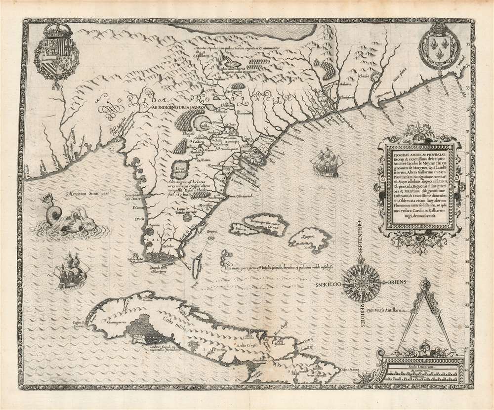

Title
Floridae Americae Provinciae Recens and Exactissima Descriptio Auctore Iacobo Le Moyne cui Cognomen de Morgues, qui Laudonierum…
1591 (undated) 14 x 18 in (35.56 x 45.72 cm) 1 : 5200000
1591 (undated) 14 x 18 in (35.56 x 45.72 cm) 1 : 5200000
Description
FOR THE ORIGINAL ANTIQUE MAP, WITH HISTORICAL ANALYSIS, CLICK HERE.
Digital Map Information
Geographicus maintains an archive of high-resolution rare map scans. We scan our maps at 300 DPI or higher, with newer images being 600 DPI, (either TIFF or JPEG, depending on when the scan was done) which is most cases in suitable for enlargement and printing.
Delivery
Once you purchase our digital scan service, you will receive a download link via email - usually within seconds. Digital orders are delivered as ZIP files, an industry standard file compression protocol that any computer should be able to unpack. Some of our files are very large, and can take some time to download. Most files are saved into your computer's 'Downloads' folder. All delivery is electronic. No physical product is shipped.
Credit and Scope of Use
You can use your digial image any way you want! Our digital images are unrestricted by copyright and can be used, modified, and published freely. The textual description that accompanies the original antique map is not included in the sale of digital images and remains protected by copyright. That said, we put significant care and effort into scanning and editing these maps, and we’d appreciate a credit when possible. Should you wish to credit us, please use the following credit line:
Courtesy of Geographicus Rare Antique Maps (https://www.geographicus.com).
How Large Can I Print?
In general, at 300 DPI, you should at least be able to double the size of the actual image, more so with our 600 DPI images. So, if the original was 10 x 12 inches, you can print at 20 x 24 inches, without quality loss. If your display requirements can accommodate some loss in image quality, you can make it even larger. That being said, no quality of scan will allow you to blow up at 10 x 12 inch map to wall size without significant quality loss. For more information, it is best consult a printer or reprographics specialist.
Refunds
If the high resolution image you ordered is unavailable, we will fully refund your purchase. Otherwise, digital images scans are a service, not a tangible product, and cannot be returned or refunded once the download link is used.
Cartographer S
Théodore de Bry (1528 - March 27, 1598) was an important publisher active in the mid to late 16th century. De Bry was born in 1528 in Liege, then a Prince-Bishopric and thus independent of neighboring nations. The De Bry family were accomplished jewelers and copperplate engravers and, following the family tradition, Theodore apprenticed in these fields under his grandfather Thiry de Bry senior (? - 1528), and later under his father, Thiry de Bry junior (1495 - 1590). To avoid growing religious strife in the region Théodore de Bry left Liege for the more tolerant Strasburg. Shortly afterwards, in 1577, he moved again to Antwerp and, in 1580 to London, where he became well known for his engraving skills. It was either in Antwerp or in London that De Bry befriended the English publisher and editor of traveler's tales Richard Hakluyt. Inspired by Hakluyt's work, De Bry began to collect travelers' tales, particularly of voyages to New World. His most prominent acquisition was most likely the letters and papers of the French painter and mapmaker Jacques Le Moyne de Morgues discussing a disastrous attempt by French Huguenots to colonize parts of Florida. Around, 1588 De Bry moved to Frankfurt where he began his own publishing firm. Among De Bry's earliest and most prominent publications are his Grands Voyages, a multivolume compilation of travelers' tales that included the work of Le Moyne as well as some of the earliest published depictions of the North American mainland. The firm also published various other works including an important account of early English attempts to colonize Virginia with illustrations by John White. De Bry died in Frankfurt on March 27, 1598, having never left the shores of Europe, though his name was associated throughout Europe with tales of travel and adventure. Théodore de Bry was succeeded by his son Jean-Théodore (1560 - 1623) who continued the publishing firm until his own death in 1623. More by this mapmaker...
Jacques Le Moyne de Morgues (c. 1533 - 1588) was a French Huguenot painter born in Dieppe, France in 1533. Little is known of Le Moyne's early life; however, as Dieppe was at the time a center for both painting and cartography, it might be assumed that Le Moyne trained in the city of his birth. It is likely that le Moyne was employed at the court of King Charles IX where he most likely first met the Huguenot Admiral Gaspard de Coligny. Coligny commissioned Le Moyne to accompany his expedition to colonize Florida, where he was to record and map as much of the New World as possible. Under the command of Jean Ribault and Rene Laudonniere from 1562 - 1564, Le Moyne created a series of illustrations and maps depicting indigenous plants, peoples of Florida. This important work, eventually published by Theodore de Bry, is considered to be among first European images of the North American mainland. His important map, Floridae Americase Provinicae is considered to be one of, if not the, most important map of Florida ever published. Nonetheless, contemporary scholars have put Le Moyne's work under intense scrutiny as no original examples of his work remain. Considering the fate of the disastrous Huguenot colony in Florida, it is understandable that little if any of Le Moyne's original work survived and, consequently, it is a safe bet that most of his work was reproduced from memory in London. More likely than not, inconsistencies between Le Moyne's representations of indigenous American peoples, flora and fauna, and actual fact can be attributed to lapses in memory. Following his return returned from the New World, Le Moyne settled in London where he became a prominent botanical illustrator, at times working with such notable personages as Sr. Walter Raleigh. His work expresses typical Calvinist attention to detail and absence of ornamentation. Le Moyne died in London in 1588 having never seen his own work published. It was not until after his death when Le Moyne's widow sold his papers to the Frankfurt publisher Theodore de Bry, that le Moyne's important illustrations of early Florida were finally published. Le Moyne's sole surviving watercolor is held in the collections of the New York Public Library. Learn More...
Source
Le Moyne de Morgues, J., Brevis Narratio Eorum Quae in Florida Americae Provicia, in De Bry, J., Grands Voyages, part II, 1591.