1866 Spanish Direccion de Hidrografia Map of Florida
Florida-direccionhidrografia-1866$950.00


Title
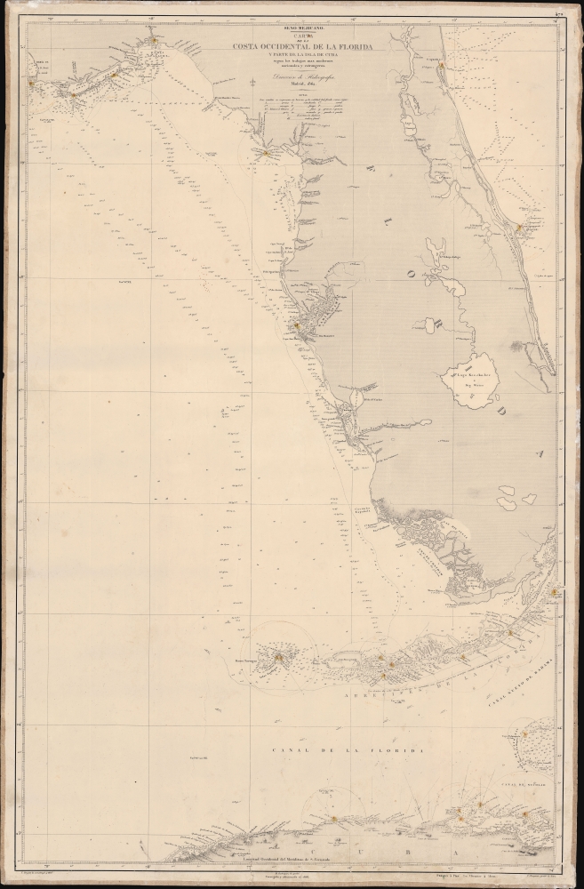
Seno Mejicano. Carta de la Costa Occidental de la Florida y Parte de La Isla de Cuba segun los trabajos mas modernos nacionales y estrangeros.
1866 (dated) 39.35 x 25.75 in (99.949 x 65.405 cm) 1 : 896200
1866 (dated) 39.35 x 25.75 in (99.949 x 65.405 cm) 1 : 896200
Description
A scarce 1866 working Spanish Dirección de Hidrografía nautical map of peninsular Florida and northern Cuba. This chart was used by the Santiago, one of the first steamships to ply the Havana-Cadiz route.
A Closer Look
Coverage embraces Florida from Saint Augustine and Apalachee Bay, south to include the Florida Keys and parts of northern Cuba. It features extensive annotation regarding navigation to and from Havana. It also notes the distance from which lighthouses are visible in Cuba and along the Florida coast. It exhibits advanced detail in the vicinity of Tampa Bay and along the Keys. The focus is more on the Gulf Side of Florida than the Atlantic, which is beyond the bounds of the map from Fort Pierce to the Miami River. Nonetheless, the chart resumes near modern-day Miami and includes the Florida Keys, named using the Spanish toponomy.Provenance
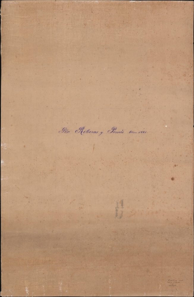
This chart was owned and sailed by Pio Riberas y Ponès from February 1881. Riberas y Ponès likely refers to Quirico Riberas y Ponès, a Spanish sea captain out of Cadiz who worked the commercial route between Cadiz and the Spanish West Indies, stopping at Puerto Rico and Havana. His ship, the Santiago, was a 1,375-horsepower steamship, one of the first to ply this route.Publication History and Census
The chart was first issued by the Dirección de Hidrografía in 1862, one year after Florida joined the Confederacy and the outbreak of the American Civil War (1861 - 1865). We find it curious that the first edition of the chart, 1862, was issued one year after the start of the war, and the present, second edition, was issued one year after the end of the war. Possibly, the chart makers intended to capitalize on new information and surveys produced as part of the war effort. The chart was drawn by Tomás Bryant y Galiano and engraved by Manuel Rodriguez and Francisco Bregante y Orbay. It is rare; in the OCLC, we note only references to the 1862 (no institutional holdings) and the 1914 (two holdings), so the 1st and 3rd editions, but no examples of this, the 1866 edition. We also note an example at the Instituto Geográfico Nacional in Madrid.CartographerS
The Direccion Hidrografía (1787 - 1927), also known as the Deposito Hydrografico and the Direction de Hidrografía, was the Spanish equivalent of the British Admiralty or the U.S. Coast Survey. This organization, founded in 1787, was commissioned to collect and produce accurate nautical charts of all waters frequented by Spanish vessels. In essence, it replaced the Casa de la Contratación de las Indias (House of Trade of the Indies), which closed its doors in 1790. Like most such organizations, the Direccion Hidrografía marked a new age in cartography. Rather than simply collect charts created by navigators, explorers, and merchants, the Direccion Hidrografía worked closely with naval and military personnel to mount cartographic and hydrographic expeditions in pursuit of the most accurate hydrographical, astronomical, and geodetic measurements. The Direccion Hidrografía created a massive library of nautical charts that, though not nearly as common as similar nautical charts by the U.S. Coast Survey and British Admiralty, are highly desirable for the beauty of their manufacture as well as their accuracy and detail. The office was originally located on Calle Ballesta, but relocated to 36 Alcala, both in Madrid. After 1908 the Dirección was subsumed into other governmental agencies. In 1927 the Direccion was absorbed into the Institute and Observatory of San Fernando, located in Cadiz. The library of original maps, charts, and journals was transferred to the Naval Museum of Madrid - where it resides to this day. More by this mapmaker...
Tomás Bryant y Galiano (fl. c. 1858 – 1879) was a Spanish navigator, sea captain, and chart maker active in the second half of the 19th century. Little is known of Bryant's life, but he appears to have been the grandson of a prominent Spanish shipbuilder Eduardo Bryant and son of Tomás Bryant y Smith (1748 – 18??). Bryant is best known for his charts of Spanish-American waters in the Caribbean and South America published by the Dirección de Hidrografía. Learn More...
Manuel Rodriguez (fl. c. 1857 – 1880) was a Spanish artist and line engraver active in Madrid in the middle to late 19th century. Rodriguez studied at the Academia de San Fernando and practiced drawing in his spare time. His drawing of a Biblical scene, Jerome in the desert, was recognized with a bronze medal by La Sociedad Económica Matritense. In 1857, he enrolled in the school of topographical engraving run by the Dirección de Hidrografía. Upon graduation he became an engraver for that organization, producing numerous nautical charts. Learn More...
Francisco Bregante y Orbay (fl. 1840 - 1867) was a Spanish engraver and draftsman active with the Dirección Hidrografía in the middle part of the 19th century. Bregante y Orbay specialized in lettering and text. A relative, Salvador Bregante y Orbay, also worked for the Dirección Hidrografía in a related capacity. Learn More...
Condition
Very good. Some minor creasing and a few pencil marks related to navigation. Backed on original old linen.
References
OCLC 557409387 (1862).