Digital Image: 1884 Drew Pocket Map of Florida
Florida-drew-1884_d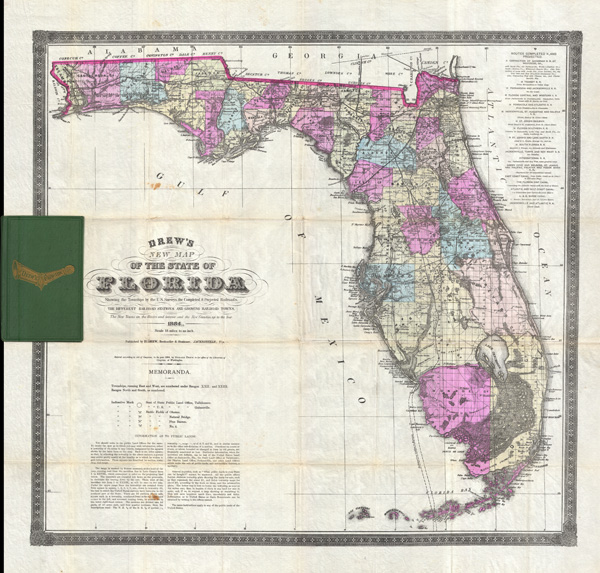

Description
FOR THE ORIGINAL ANTIQUE MAP, WITH HISTORICAL ANALYSIS, CLICK HERE.
Digital Map Information
Geographicus maintains an archive of high-resolution rare map scans. We scan our maps at 300 DPI or higher, with newer images being 600 DPI, (either TIFF or JPEG, depending on when the scan was done) which is most cases in suitable for enlargement and printing.
Delivery
Once you purchase our digital scan service, you will receive a download link via email - usually within seconds. Digital orders are delivered as ZIP files, an industry standard file compression protocol that any computer should be able to unpack. Some of our files are very large, and can take some time to download. Most files are saved into your computer's 'Downloads' folder. All delivery is electronic. No physical product is shipped.
Credit and Scope of Use
You can use your digial image any way you want! Our digital images are unrestricted by copyright and can be used, modified, and published freely. The textual description that accompanies the original antique map is not included in the sale of digital images and remains protected by copyright. That said, we put significant care and effort into scanning and editing these maps, and we’d appreciate a credit when possible. Should you wish to credit us, please use the following credit line:
Courtesy of Geographicus Rare Antique Maps (https://www.geographicus.com).
How Large Can I Print?
In general, at 300 DPI, you should at least be able to double the size of the actual image, more so with our 600 DPI images. So, if the original was 10 x 12 inches, you can print at 20 x 24 inches, without quality loss. If your display requirements can accommodate some loss in image quality, you can make it even larger. That being said, no quality of scan will allow you to blow up at 10 x 12 inch map to wall size without significant quality loss. For more information, it is best consult a printer or reprographics specialist.
Refunds
If the high resolution image you ordered is unavailable, we will fully refund your purchase. Otherwise, digital images scans are a service, not a tangible product, and cannot be returned or refunded once the download link is used.
Cartographer
Columbus Drew (January 6, 1820 - July 8, 1891) was a Florida lawyer, politician, writer, bookseller, publisher, and printer active in the mid to late 19th century. Drew was born in Virginia and grew up in Washington D.C., earning a law degree. As a young man he worked with Gales and Seaton of the National Intelligencer. By 1847 he was working as an editor of the Whig-leaning American. Before the American Civil War (1861 - 1865), Drew was an ardent Whig. He was enticed to relocate to Jacksonville, Florida in 1848 to edit the Florida-Whig journal Republican. In 1855, Drew established his stationers business - one of the first in Jacksonville. Although as a Whig he opposed both slavery and the succession, when the Civil War broke out he remained loyal to his adopted state and worked for the Confederate cause. Drew moved briefly to Richmond to take a position in the Confederate Treasury Department. After the war he returned to his stationers shop in Jacksonville where he applied for and received a Federal Pardon for working with the Confederacy. In 1876, Drew was called upon to assume the post of state Comptroller. At this time he sold his stationery business to his son, Horace (January 20, 1854 - January 4, 1926), who renamed it 'H. Drew Company'. Shortly thereafter, in 1886, Horace took on his younger brother, William B. Drew, as a partner, renaming the firm 'H. Drew and Brother'. The name was again changed in 1893, when it was formally incorporated as 'H. and W. B. Drew Company'. This firm still operates as 'Wells and Drew'. Columbus Drew was a leading figure in the development of Florida during the Reconstruction Era following the Civil War. His influence impacted the development of state railways, canals, drainage projects, and other civil works. Cartographically he is best known for the publication of his 1867 New Map of the State of Florida, which, through numerous editions and revisions, chronicles the history and development of the state during a critical period. This map is now extremely scarce in any edition. Horace Drew, who continued to publish an update his father's important map. The Drew family became leading citizens in Jacksonville and today their historic Victorian home enjoys landmark status. Drew is interred at the Old Jacksonville City Cemetery. More by this mapmaker...
References
Rumsey, 5190.001 (1870 edition). Fitzgerald, 167 (1874 edition). Phillips, (maps) 285 (1874 edition). Library of Congress, Map Division, G3931.P3 1874 .D7 RR 195. Baxter, J. M., Tequesta - An Annotated Checklist of Florida Maps, p. 115.