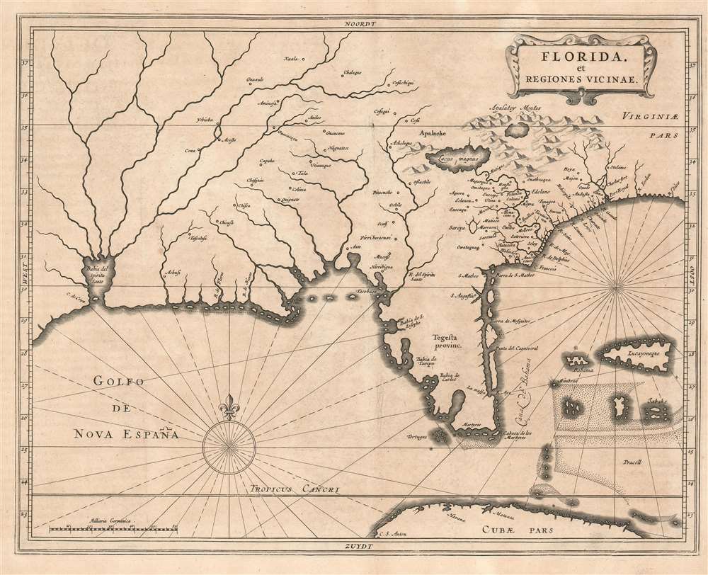
1630 De Laet Map of Florida and the American Southeast
Floridaetregiones-delaet-1630$3,500.00

Title
Florida, et Regiones Vicinae.
1630 (undated) 12 x 14.5 in (30.48 x 36.83 cm) 1 : 3800000
1630 (undated) 12 x 14.5 in (30.48 x 36.83 cm) 1 : 3800000
Description
One of the great foundational maps of the American southeast, this is Johannes de Laet's 1630 map of Florida. At the time, Florida referred to a vast region extending from Virginia to the Mississippi Valley, and this map correspondingly covers that region. De Laet based the map on a variety of sources, particularly on Cornelius Claesz's 1602 interpretation of Jacques Le Moyne's map of 1591, the Abraham Ortelius-Hieronymo de Chaves map of 1584, and the Mercator-Hondius map of 1606.
The most significant deviation from Le Moyne's map is Hondius' placement of the River May and Lake Apalachy, here identified as the 'Lacus Magnus.' Where Le Moyne correctly mapped the River May (St. John's River, Florida) in an inverted 'V' form, first heading north, then south to meet with a large inland lake (in all likelihood Lake George or one of the other great inland lakes of Florida), Hondius maps the course of the May heading from the northwest, thus relocating the 'Lacus Magnus,' or as described by Hondius, 'Lacus Aquae Dulcis,' far to the north. This error can be understood in terms of magnetic variation, temperature issues associated with isothermal lines, and navigational errors related to the confusion of the star Asfick with Polaris. While Le Moyne correctly located the mouth of the River May at thirty degrees of latitude, Hondius maps it between thirty-one and thirty-two degrees. This may have caused an erroneous association of the River May with the Savannah River. Thus, while the River May dips southward, the Savannah River heads almost directly northwest into the Appalachian Mountains, forming the modern southern border of South Carolina. Hondius, no doubt taking his cue from navigators who rarely trekked inland, therefore rerouted the May River to flow from the northwest. Without an accurate picture of the interior, Hondius followed Le Moyne's example and translocated the great freshwater lake to the north. Others have speculated that the Le Moyne's River May is, in fact, the St. John's River and that the 'Lacus Magnus' is the Okefenokee Swamp - but this argument does not coincide with most scholarship. The influence of the Mercator-Hondius firm was so pronounced in Europe that most subsequent cartographers followed their lead, particularly in this case, De Laet. The 'Lacus Magnus' or 'Lacus Aquae Dulcis,' or 'Great Freshwater Lake of the Southeast,' is, of course, apocryphal, but it appeared on maps well into the 18th century.
Tegesta
This is the first map to apply the name Tegesta (Tegesta Provinc.) to what is today Florida. The Tegesta (Tekesta, Tegesta, Chequesta, Vizcaynos) were an American Indian tribe living in the southeastern parts of Florida, including most of Miami-Dade County and the Florida Keys. Their main village was on Biscayne Bay, where they encountered Juan Ponce de León, Pedro Menéndez de Avilés, and the French settlers under Rene Goulaine de Laudonnière. They played a significant role in the early European settlement and exploration of Florida. The term Tegesta, as applied to Florida, was followed by most other cartographers in the subsequent decades until the prominence of the English settlements to the north pushed Spanish 'Florida' ever further south. As for the Tegesta, they persisted in the region until 1763, when, with the Spanish surrender to Great Britain, they evacuated to Cuba.The Bahia del Spiritu Santo
It has been argued that the great bay in the western part of the map, 'Bahia del Spiritu Santo,' may be an early representation of the Mississippi River Delta. It certainly seems to be the source of a great inland system, but one bearing no serious resemblance to the Mississippi, either in the form of the delta or the river system itself. The earliest maps of the Gulf of Mexico to show the 'Bahia del Spiritu Santo' place it in the northwestern quadrant of the Gulf, in the vicinity of Galveston or Matagorda Bay. Some later maps, such as the present map, move the 'Bahia del Spiritu Santo' to a region just to the west of Florida where it again is out of place for the Mississippi but could represent Mobile Bay. While serious exploration was limited, there were navigators who claimed to be familiar with the Gulf Coast even in the early 16th century. It is not unlikely that written accounts of visits to the Gulf Coast resulted in many of the bays there being discovered but not formally triangulated or entered into the record. In interpreting these accounts, it is not hard to imagine confused cartographers applying established nomenclature to unrelated geographical elements. Either way, we find the theory that the 'Bahia del Spiritu Santo' has any relationship to the Mississippi to be untenable.The American Southeast
The eastern region appears to derive from the Mercator-Hondius map of what constitutes modern-day Georgia and South Carolina. This region was tenuously mapped by the French during their disastrous attempt to settle Florida between 1552 and 1565 when the Spaniards of St. Augustine finally drove them out. Le Moyne was part of this expedition, and although the French settlers likely did very little actual mapping of the interior, good terms with the indigenous Floridians did enable them to produce an impressive and surprisingly accurate early map of the southeast. The Le Moyne-De Bry map, as it is known, identifies several major lakes in the interior of Florida, some of which are noted here. Nonetheless, where Le Moyne was surprisingly accurate, this interpretation, based on Mercator-Hondius, is surprisingly erroneous.The most significant deviation from Le Moyne's map is Hondius' placement of the River May and Lake Apalachy, here identified as the 'Lacus Magnus.' Where Le Moyne correctly mapped the River May (St. John's River, Florida) in an inverted 'V' form, first heading north, then south to meet with a large inland lake (in all likelihood Lake George or one of the other great inland lakes of Florida), Hondius maps the course of the May heading from the northwest, thus relocating the 'Lacus Magnus,' or as described by Hondius, 'Lacus Aquae Dulcis,' far to the north. This error can be understood in terms of magnetic variation, temperature issues associated with isothermal lines, and navigational errors related to the confusion of the star Asfick with Polaris. While Le Moyne correctly located the mouth of the River May at thirty degrees of latitude, Hondius maps it between thirty-one and thirty-two degrees. This may have caused an erroneous association of the River May with the Savannah River. Thus, while the River May dips southward, the Savannah River heads almost directly northwest into the Appalachian Mountains, forming the modern southern border of South Carolina. Hondius, no doubt taking his cue from navigators who rarely trekked inland, therefore rerouted the May River to flow from the northwest. Without an accurate picture of the interior, Hondius followed Le Moyne's example and translocated the great freshwater lake to the north. Others have speculated that the Le Moyne's River May is, in fact, the St. John's River and that the 'Lacus Magnus' is the Okefenokee Swamp - but this argument does not coincide with most scholarship. The influence of the Mercator-Hondius firm was so pronounced in Europe that most subsequent cartographers followed their lead, particularly in this case, De Laet. The 'Lacus Magnus' or 'Lacus Aquae Dulcis,' or 'Great Freshwater Lake of the Southeast,' is, of course, apocryphal, but it appeared on maps well into the 18th century.
A Lake with a Waterfall?
Another curious and striking element drawn directly from the Le Moyne map is the curious lake just northeast of the 'Lacus Magnus.' On the Le Moyne map, this lake is fed by a great waterfall, which has been the cause of considerable curiosity. To our knowledge, there are but two maps that depict this lake with the waterfall: the original Le Moyne map and the Mercator-Hondius Map. This map by De Laet includes the lake but curiously deletes the waterfall. Moreover, close study shows that not only was the waterfall removed, but it was scratched out of the original plate, along with the northern shore of the lake, sometime after the plate was cut. Scholarship suggests that there is only one plate of this map, but we would not be surprised if, at some point, an earlier unpublished proof state including the waterfall is discovered. This smaller lake disappeared from most subsequent maps.Publication History
This map is one of a series of North American maps that accompanied Johannes de Laet's Nieuwe Wereldt ofte Beschrijvinghe van West-Indien. It was engraved by none other than Hessel Gerritsz, who had been the official cartographer to the Dutch East India Company since 1617. As such, he would have had access to unpublished voyage data, which doubtless found its way into this map. Ultimately, it was the best map of the region at the time of publication, and its influence was significant. Subsequent cartographers, including Blaeu, Jansson, and Sanson, followed De Laet's model and nomenclature. An essential piece for regional Southeast and Florida collectors.CartographerS
Johannes de Laet (1581 – December 15, 1649) was a Dutch businessman and cartographer active in Leiden during the early 17th century. De Laet was a Flemish Protestant born in Antwerp to a prosperous merchant family in the cloth trade. When Antwerp fell to the Catholic Spanish in August of 1585, he and his family fled to the northern Netherlands. At the University of Leiden, he studied Theology and Philosophy, matriculating in 1597. In 1603 he relocated to London, where he acquired denizenship, an early type of citizenship and married. His Anglo-Dutch wife died shortly afterward and he returned to Leiden, where he married again. He cleverly invested in Dutch land reclamation projection and the overseas trade, becoming extremely wealthy. In 1620, he became a founding director of the Dutch West Indies Company, a position he held until his death. His most important cartographic work, Nieuwe Wereldt ofte Beschrijvinghe van West-Indien has been hailed by the map historian Phillip Burden as 'arguably the finest description of the Americas published in the 17th century. It contained several seminal maps of the Americas that significantly advanced cartographic perspectives on the region and served as a foundational work for subsequent cartographers. De Laet died in Den Haag (The Hague) in 1649. More by this mapmaker...
Hessel Gerritsz (1581 – September 4, 1632) was a Dutch engraver, cartographer, and publisher active in Amsterdam during the late 16th and early 17th centuries, among the most preeminent Dutch geographers of the 17th century. He was born in Assum, a town in northern Holland in 1581. As a young man he relocated to Alkmaar to accept an apprenticeship with Willem Jansz Blaeu (1571-1638). He followed Blaeu to Amsterdam shortly afterwards. By 1610 he has his own press, but remained close to Blaeu, who published many of his maps. In October of 1617 he was appointed the first official cartographer of the Vereenigde Oost-Indische Compagnie (Dutch East Indian Company) or VOC. This strategic position offered him unprecedented access to the most advanced and far-reaching cartographic data of the Dutch Golden Age. Unlike many cartographers of his period, Gerritsz was more than a simple scholar and showed a true fascination with the world and eagerness to learn more of the world he was mapping in a practical manner. In 1628 he joined a voyage to the New World which resulted in the production of his seminal maps, published by Joannes de Laet in his 1630 Beschrijvinghe van West-Indien; these would be aggressively copied by both the Blaeu and Hondius houses, and long represented the standard followed in the mapping of the new world. Among his other prominent works are a world map of 1612, a 1613 map of Russia by the brilliant Russian prince Fyodor II Borisovich Godunov (1589 – 1605), a 1618 map of the pacific that includes the first mapping of Australia, and an influential 1630 map of Florida. Gerritsz died in 1632. His position with the VOC, along with many of his printing plates, were taken over by Willem Janszoon Blaeu. Learn More...
Source
De Laet, J., Nieuwe Wereldt ofte Beschrijvinghe van West-Indien, (Leiden: Bonaventure and Abraham ) 1630.
Condition
Very good. Even overall toning.
References
Burden, P., The Mapping of North America, #232. Cumming, W., The Southeast in Early Maps, #34.