1741 Homann Heirs Map of France
France-hmhr-1741-2$450.00
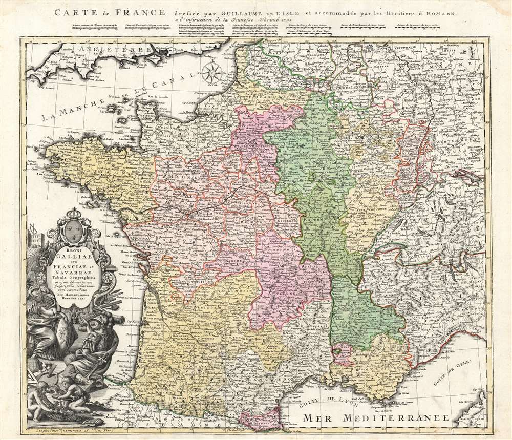

Title
Regni Galliae seu Franciae et Navarrae Tabula Geographica in usum Elementorum Geographiae Schaziano rum accomodata Per Homannianos Heredes 1741. / Carte de France dressee par Guillaume de L'Isle et accommodee par les Heritiers d'Homann a l'instruction de la Jeunesse Norimb. 1741.
1741 (dated) 20 x 23 in (50.8 x 58.42 cm) 1 : 2000000
1741 (dated) 20 x 23 in (50.8 x 58.42 cm) 1 : 2000000
Description
A beautifully detailed 1741 Homann Heirs map of France, specially engraved for inclusion in Johann Schatz's school atlas. Depicting the Kingdoms of France and Navarre, along with parts of Italy, Switzerland, Spain, and Germany, the map offers excellent detail, illustrating fortified cities, villages, roads, bridges, forests, and castles. Topography is illustrated pictorially.
In the upper margin is an additional title in French, as well as the map's scales for no fewer than ten separate reckonings of leagues, nine of which were in use in different parts of France.
The Cartouche
The map's allegorical title cartouche features Ares (armed with a sword and fiercely bearded) in discourse with Athena (also armed, with spear and medusa shield). While both were classical gods of war, Ares was the patron of war's violence, horror, and passion, while Athena's metier was 'wisdom in war', cleverness, and strategy. In the eyes of the classical scholars of the seventeenth and eighteenth centuries, Athena's sphere would expand to embrace the arts, science, and technology. On the ground between them are paintbrushes, a palette, globe, and geographers' tools. Behind the pair of gods is a large baroque plinth surmounted by the French royal crest. Sprouting from Ares' side of the plinth are the tools of war: spears, cannon, and cannonballs. In the background on Athena's side is an observatory. Ares is holding his sword behind his back: either he thinks he can pull a fast one on Athena (a bad plan if the stories are anything to go by) or he's simply not brandishing it at her (a better plan, though to be fair Ares always came off as pretty dumb so this is a long shot). In the foreground below two children (wingless putti?) are making wine, possibly to soothe ill-temper and prevent any imminent conflict.In the upper margin is an additional title in French, as well as the map's scales for no fewer than ten separate reckonings of leagues, nine of which were in use in different parts of France.
Homann Heirs but Not Homann
The source for this map chosen by Schatz, interestingly, is not the elder Homann's work. Although Johann Baptiste Homann had produced his own map of France, Schatz instead selected Guillaume De l'Isle's Carte De France as a model. This is perhaps a testament to the authority invested in De l'Isle, whose position as Geographer to the King of France preserved his place at the forefront of geography long after his death.Publication History and Census
This map was engraved in Nuremberg by the firm of the Heirs of Homann, for inclusion in Johann Jacob Schatz's Erste Anfangs-Gründe Der Geographie... A later state of the map, as late as 1778, bears the Imperial Privilege, lacking here. This 1741 state is listed in sixteen separate examples in OCLC.CartographerS
Homann Heirs (1730 - 1848) were a map publishing house based in Nuremberg, Germany, in the middle to late 18th century. After the great mapmaker Johann Baptist Homann's (1664 - 1724) death, management of the firm passed to his son Johann Christoph Homann (1703 - 1730). J. C. Homann, perhaps realizing that he would not long survive his father, stipulated in his will that the company would be inherited by his two head managers, Johann Georg Ebersberger (1695 - 1760) and Johann Michael Franz (1700 - 1761), and that it would publish only under the name 'Homann Heirs'. This designation, in various forms (Homannsche Heirs, Heritiers de Homann, Lat Homannianos Herod, Homannschen Erben, etc..) appears on maps from about 1731 onwards. The firm continued to publish maps in ever diminishing quantities until the death of its last owner, Christoph Franz Fembo (1781 - 1848). More by this mapmaker...
The De L'Isle family (fl. c. 1700 - c. 1760) (also written Delisle) were, in composite, a mapmaking tour de force who redefined early 18th century European cartography. Claude De L'Isle (1644 -1720), the family patriarch, was Paris based a historian and geographer under Nicholas Sanson. De L'Isle and his sons were proponents of the school of "positive geography" and were definitive figures, defining the heights of the Golden Age of French Cartography. Of his twelve sons, four, Guillaume (1675 - 1726), Simon Claude (1675 - 1726), Joseph Nicholas (1688 - 1768) and Louis (1720 - 1745), made a significant contributions to cartography. Without a doubt Guillaume was the most remarkable member of the family. It is said that Guillaume's skill as a cartographer was so prodigious that he drew his first map at just nine years of age. He was tutored by J. D. Cassini in astronomy, science, mathematics and cartography. By applying these diverse disciplines to the vast stores of information provided by 18th century navigators, Guillaume created the technique that came to be known as "scientific cartography", essentially an extension of Sanson's "positive geography". This revolutionary approach transformed the field of cartography and created a more accurate picture of the world. Among Guillaume's many firsts are the first naming of Texas, the first correct map of the Mississippi, the final rejection of the insular California fallacy, and the first identification of the correct longitudes of America. Stylistically De L'Isle also initiated important changes to the medium, eschewing the flamboyant Dutch style of the previous century in favor of a highly detailed yet still decorative approach that yielded map both beautiful and informative. Guillaume was elected to the French Academie Royale des Sciences at 27. Later, in 1718, he was also appointed "Premier Geographe du Roi", an office created especially for him. De L'Isle personally financed the publication of most of his maps, hoping to make heavy royalties on their sales. Unfortunately he met an untimely death in 1728, leaving considerable debt and an impoverished child and widow. De L'Isle's publishing firm was taken over by his assistant, Phillipe Buache who became, posthumously, his son in law. The other De L'Isle brothers, Joseph Nicholas and Louis De L'Isle, were employed in the Service of Peter the Great of Russia as astronomers and surveyors. They are responsible for cataloguing and compiling the data obtained from Russian expeditions in the Pacific and along the northwest coast of America, including the seminal explorations of Vitus Bering and Aleksei Chirikov. The De L'Isles, like their rivals the Vaugondys , must be considered speculative geographers. Speculative geography was a genre of mapmaking that evolved in Europe, particularly Paris, in the middle to late 18th century. Cartographers in this genre would fill in unknown areas on their maps with speculations based upon their vast knowledge of cartography, personal geographical theories, and often dubious primary source material gathered by explorers and navigators. This approach, which attempted to use the known to validate the unknown, naturally engendered many rivalries. The era of speculatively cartography effectively ended with the late 18th century explorations of Captain Cook, Jean Francois de Galaup de La Perouse, and George Vancouver. Learn More...
Johann Jacob Schatz (1691 - 1760) was a German schoolmaster, librarian, classical philologistphilologist and historian who lived and worked in Strasbourg. He was prolific, with geographical and historical works published in Nuremberg and Leipzig beginning in 1726 and continuing lifelong. He seems to have had a long relationship with the firm of Homann Heirs. Despite his considerable output, there is nothing recorded of his life, education, or history. Learn More...
Source
Schatz, Johann Jacob, Erste Anfangs-Gründe Der Geographie... (Nuremburg: Homann Heirs), 1741.
Condition
Very good. Original wash color. Few minor spots, else excellent.
References
OCLC 248647108.