Digital Image: 1952 Dumont / Baltus Pictorial Map of French, Belgian, and Luxembourgish Cathedrals
FranceCathedrals-dumontbaltus-1952_d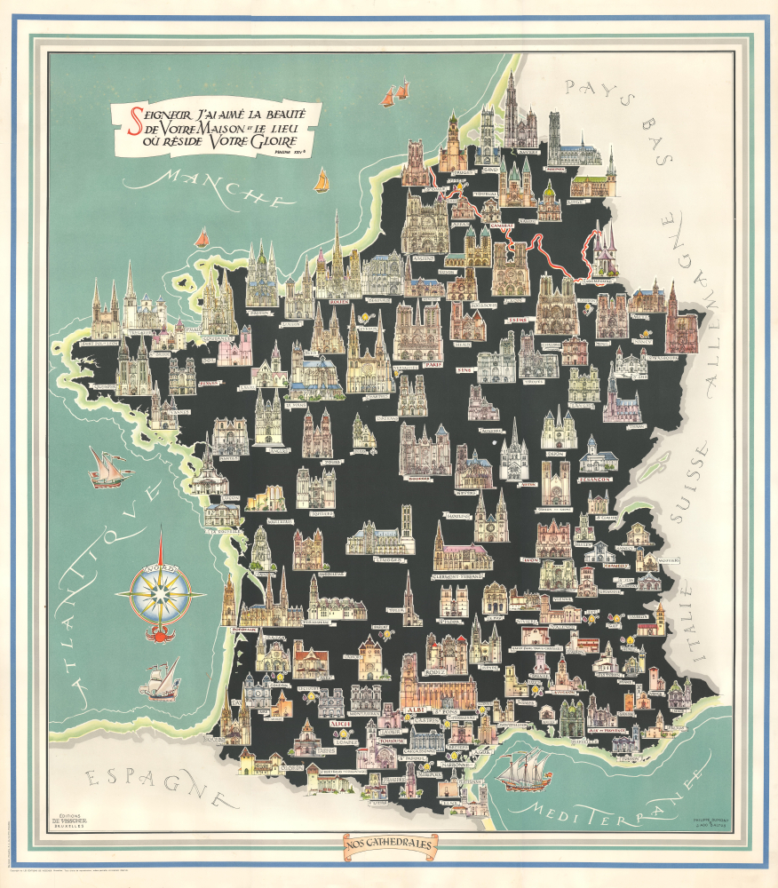


Title
Nos Cathedrales.
1952 (undated) 39.25 x 34.5 in (99.695 x 87.63 cm) 1 : 1250000
1952 (undated) 39.25 x 34.5 in (99.695 x 87.63 cm) 1 : 1250000
Description
FOR THE ORIGINAL ANTIQUE MAP, WITH HISTORICAL ANALYSIS, CLICK HERE.
Digital Map Information
Geographicus maintains an archive of high-resolution rare map scans. We scan our maps at 300 DPI or higher, with newer images being 600 DPI, (either TIFF or JPEG, depending on when the scan was done) which is most cases in suitable for enlargement and printing.
Delivery
Once you purchase our digital scan service, you will receive a download link via email - usually within seconds. Digital orders are delivered as ZIP files, an industry standard file compression protocol that any computer should be able to unpack. Some of our files are very large, and can take some time to download. Most files are saved into your computer's 'Downloads' folder. All delivery is electronic. No physical product is shipped.
Credit and Scope of Use
You can use your digial image any way you want! Our digital images are unrestricted by copyright and can be used, modified, and published freely. The textual description that accompanies the original antique map is not included in the sale of digital images and remains protected by copyright. That said, we put significant care and effort into scanning and editing these maps, and we’d appreciate a credit when possible. Should you wish to credit us, please use the following credit line:
Courtesy of Geographicus Rare Antique Maps (https://www.geographicus.com).
How Large Can I Print?
In general, at 300 DPI, you should at least be able to double the size of the actual image, more so with our 600 DPI images. So, if the original was 10 x 12 inches, you can print at 20 x 24 inches, without quality loss. If your display requirements can accommodate some loss in image quality, you can make it even larger. That being said, no quality of scan will allow you to blow up at 10 x 12 inch map to wall size without significant quality loss. For more information, it is best consult a printer or reprographics specialist.
Refunds
If the high resolution image you ordered is unavailable, we will fully refund your purchase. Otherwise, digital images scans are a service, not a tangible product, and cannot be returned or refunded once the download link is used.
Cartographer S
Jean Ado Baltus (May 25, 1918 - September 17, 1990) was a Belgian architect, draughtsman, designer, and painter. His father, Georges Balthus (1874 - 1967), was also a painter who had studied and taught art in France, Italy, and Scotland, while his mother, Bertha, was the daughter of German sculptor Adolf von Hildebrand (1847 - 1921). The younger Balthus studied at the Royal Academy of Fine Arts in Brussels, completing his studies in 1943. In his younger years, he focused on sketches of trains, military vehicles, and automobiles, and later in his career shifted focus to landscapes, especially of the Italian countryside. His interest in technical subjects also served him well as an architect and restorer of historical buildings, including the Galerie Ravenstein and Palais d’Egmont. He served as the Head Architect for the 1958 Expo (World's Fair) in Brussels and was the director of the Academy of Visual Arts in Etterbeek. More by this mapmaker...
Philippe Dumont (November 29, 1914 - February 3, 1988) was a Belgian artist, architect, and architectural restorer. His father François Dumont was a painter and his uncle Alexis Dumont was an architect, with whom he would go into business in the 1950s and 1960s (the two may belong to the same family as Joseph Jonas Dumont, 1818 - 1859, a Belgian architect who primarily restored cathedrals). Aside from his uncle, Philippe Dumont collaborated on several projects with painter-architect Jean Ado Baltus, including the Galerie Ravenstein and a series of pictorial maps of Luxembourg and different provinces of Belgium in the 1950s. Learn More...
References
OCLC 1277172454, 1082910180 (1965 edition).