1952 Dumont / Baltus Pictorial Map of French, Belgian, and Luxembourgish Cathedrals
FranceCathedrals-dumontbaltus-1952$1,200.00


Title
Nos Cathedrales.
1952 (undated) 39.25 x 34.5 in (99.695 x 87.63 cm) 1 : 1250000
1952 (undated) 39.25 x 34.5 in (99.695 x 87.63 cm) 1 : 1250000
Description
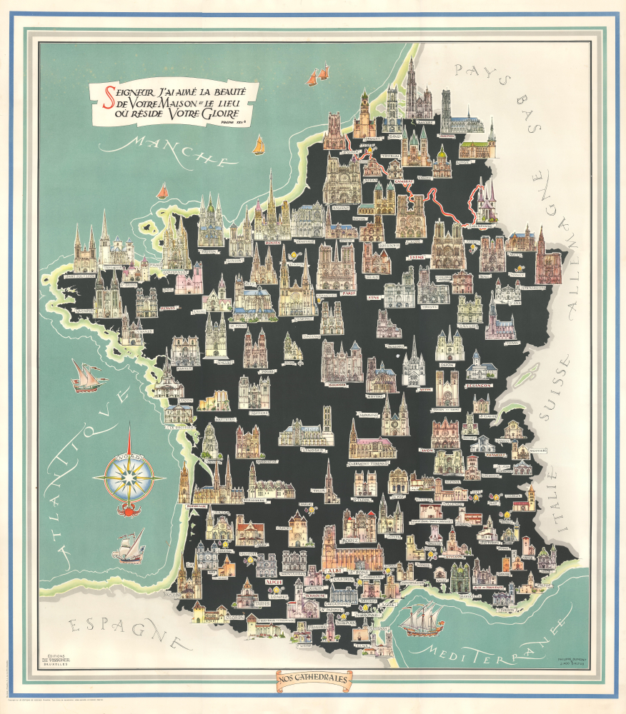
This is Philippe Dumont and J. Alo Balthus' c. 1952 striking large-format pictorial map of France, Belgium, and Luxembourg, illustrating their major cathedrals. Dumont and Baltus were both artist-architects with a deep interest in restoring historical buildings, especially cathedrals. Their efforts can be seen as an attempt to reinforce social stability and national identity in the wake of two destructive world wars.
There are three printings of the map, one dated 1952, one dated 1964, and the present undated printing, all of which are scarce. There are also some minor differences between them, such as the placement of the title and publication information. Regardless of edition, the map is only noted in the OCLC among the holdings of the British Library and the Centre Canadien d'Architecture.
A Closer Look
The map covers Belgium, Luxembourg, and France, from Anvers in the north to the Basque Country and the Pyrenees in the south. Roughly one hundred cathedrals are illustrated throughout, from the grandest of the grand (Amiens, Rouen, Chartres, to name a few), to the relatively modest, such as those in Grasse and Cambrai. Eighteen cathedrals are referred to only with an illustration of a bishop's hat, staff, and hand giving a blessing, presumably because space constraints did not allow them to be illustrated as the others. In addition to the cathedrals, the seas surrounding France are illustrated with boats and labeled with elaborate writing reminiscent of the engraved maps of the early modern period. A quote from Psalm 25 (Psalm 26 in the King James Bible) appears at top-left: 'Lord, I have loved the house where you live, the place where your glory dwells.'Seeking stability
Dumont and Baltus, both Belgians, had technical training and experience as architects in addition to their artistic pursuits. They worked together on the restoration of Galerie Ravenstein in Brussels, seen as a model of historical rehabilitation for modern uses, and both shared an interest in restoring historic cathedrals in France and the Low Countries. To this end, they published a book on the topic in 1952, which was published in several additional editions into the mid-1960s. Although not explicitly stated, it is likely that the effort to shore up or restore cathedrals was also an attempt to buttress religious and national identity following the destruction and humiliation caused by the world wars. The connection was more than symbolic; the Reims, Verdun, Ypres, Cambrai, St. Quentin, Arras, and Noyon cathedrals were all heavily damaged during World War I (1914 - 1918), while the cathedrals of Strasbourg, Rouen, Chartres, Notre Dame de Paris, and Tournai suffered significant damage during World War II (1939 - 1945).Chromolithography
Chromolithography, sometimes called oleography, is a color lithographic technique developed in the mid-19th century. The process involved using multiple lithographic stones, one for each color, to yield a rich composite effect. Oftentimes, the process would start with a black basecoat upon which subsequent colors were layered. Some chromolithographs used 30 or more separate lithographic stones to achieve the desired product. Chromolithograph color could also be effectively blended for even more dramatic results. The process became extremely popular in the late 19th and early 20th centuries when it emerged as the dominant method of color printing. The vivid color chromolithography produced made it exceptionally effective for advertising and propaganda imagery.Publication History and Census
This map was drawn by Philippe Dumont and Jean Ado Baltus, printed by Etablissements généraux d'imprimerie, and published by Editions de Visscher in Brussels. This map is a separate issue, but was published simultanouslly a book by the same makers titled Nos cathédrales: silhouettes et notices.There are three printings of the map, one dated 1952, one dated 1964, and the present undated printing, all of which are scarce. There are also some minor differences between them, such as the placement of the title and publication information. Regardless of edition, the map is only noted in the OCLC among the holdings of the British Library and the Centre Canadien d'Architecture.
CartographerS
Jean Ado Baltus (May 25, 1918 - September 17, 1990) was a Belgian architect, draughtsman, designer, and painter. His father, Georges Balthus (1874 - 1967), was also a painter who had studied and taught art in France, Italy, and Scotland, while his mother, Bertha, was the daughter of German sculptor Adolf von Hildebrand (1847 - 1921). The younger Balthus studied at the Royal Academy of Fine Arts in Brussels, completing his studies in 1943. In his younger years, he focused on sketches of trains, military vehicles, and automobiles, and later in his career shifted focus to landscapes, especially of the Italian countryside. His interest in technical subjects also served him well as an architect and restorer of historical buildings, including the Galerie Ravenstein and Palais d’Egmont. He served as the Head Architect for the 1958 Expo (World's Fair) in Brussels and was the director of the Academy of Visual Arts in Etterbeek. More by this mapmaker...
Philippe Dumont (November 29, 1914 - February 3, 1988) was a Belgian artist, architect, and architectural restorer. His father François Dumont was a painter and his uncle Alexis Dumont was an architect, with whom he would go into business in the 1950s and 1960s (the two may belong to the same family as Joseph Jonas Dumont, 1818 - 1859, a Belgian architect who primarily restored cathedrals). Aside from his uncle, Philippe Dumont collaborated on several projects with painter-architect Jean Ado Baltus, including the Galerie Ravenstein and a series of pictorial maps of Luxembourg and different provinces of Belgium in the 1950s. Learn More...
Condition
Good. Some minor edge wear and verso reinforcement. Light spotting upper quadrants.
References
OCLC 1277172454, 1082910180 (1965 edition).