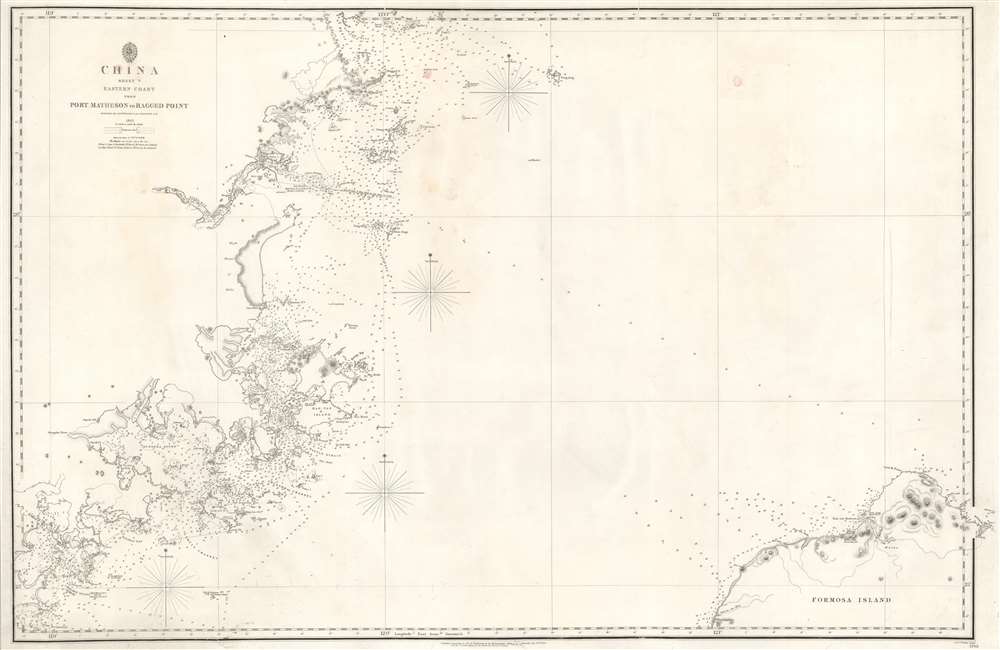
1849 Collinson / Admiralty Chart or Map of Fujian and Taiwan (Formosa)
FujianTaiwan-admiralty-1849$850.00

Title
China Sheet V Eastern Coast from Port Matheson to Ragged Point.
1849 (dated) 25.5 x 39.5 in (64.77 x 100.33 cm) 1 : 300000
1849 (dated) 25.5 x 39.5 in (64.77 x 100.33 cm) 1 : 300000
Description
An uncommon 1849 nautical chart or maritime map illustrating China's Fujian Coast and Northwestern Taiwan. The map covers the China coast from Port Matheson to Raged Point. Coverage extends inland on the mainland along the Min River as far as Fuzhou (Fou-Chow Fou) and its famous bridge; and inland on Taiwan / Formosa to include TamSui Harbor (Taipei) and Keelung (Kelung).
Collinson's Surveys
This map is the product of a series of surveys completed by Richard Collinson following the First Opium War (1839 - 1842). The survey work went on from 1842 - 1846, suggesting that this part of the coast was exceptionally important and given primacy early in the survey. Other maps in Collinson's survey include some of the fist scientific hydrographic maps of the Pearl River and Hong Kong. On this map, the course between Keelung Harbor and the mouth of the Min River appears as a line of soundings, underscoring the primacy of this route for maritime trade.Publication History and Census
This map was engraved by J. and C. Walker and first issued by the British Admiralty in 1843, shortly after the first Opium War (1839 - 1842). It was updated and revised to 1849 - just in time for the Second Opium War (1856 - 1860). The cartography is derived for Kellett and Richard Collinson, the most important British surveyors active in China before and during the First Opium War. This map is scarce. It does appear in the OCLC, but no institutional holdings are identified. We are aware of two that have sold privately in the last 10 years.CartographerS
Richard Collinson (November 7, 1811 – September 13, 1883) was an English naval officer, marine surveyor, and Arctic explorer. He was born in Gateshead, Tyne and Wear, England, then part of Durham. He joined the Royal Navy in 1823, at age twelve, and rose in the ranks, becoming a lieutenant in 1835, commander in 1841, and captain in 1842. Collinson was a highly capable captain. He participated with distinction in the First Opium War (1839 - 1842). After the war, along with Commander Henry Kellett, he completed a series of pioneering surveys of the China coast from the Yangtze River to Hong Kong. These he completed between 1842 and 1846 while serving as commander of the HMS Plover. In 1850, he was sent north in command of the HMS Enterprise to search for survivors of the Sir John Franklin expedition. Although he came quite close, he never found Franklin's lost men and returned to England without success. Nonetheless, he was honored by the Royal Geographical Society for his surveys in the Arctic and proof that it was navigable from the Behring Strait to King William's Land. Collinson was Knighted in 1875, the same year in which he retired from active duty with the rand of Admiral. Collinson died in September of 1883. More by this mapmaker...
The British Admiralty Office (1795 - Present) or the United Kingdom Hydrographic Office refers to the Branch of the English government that is responsible for the command of the British Navy. In 1795 King George III created the United Kingdom Hydrographic Office, known in short as the U.K.H.O., to provide top notch nautical charts to the vast Royal Navy. Prior the founding of the Admiralty the surveying and creation of nautical charts was primarily a commercial venture wherein the cartographer himself, more of than not, actually financed the printing of his own material. The great navigator Cook himself is known to have scrambled for funds to publish his own seminal charts - the most important and advanced of the period. The system of privately funded nautical mapping and publishing left vast portions of the world uncharted and many excellent charts unpublished. King George III, responding significant loss in trade revenue related to shipwrecks and delay due to poor charts, recognized the need for an institutionalized government sponsored cartographic agency - the Admiralty. The first head of the Admiralty, a position known as Hydrographer, was the important cartographer Alexander Dalrymple. Dalrymple started by organizing and cataloging obtainable charts before initiating the laborious process of updating them and filling in the blanks. The first official Admiralty Chart appeared in 1800 and detailed Quiberon Bay in Brittany. By 1808 the position of Hydrographer fell to Captain Thomas Hurd. Hurd advocated the sale of Admiralty charts to the general public and, by the time he retired in 1829, had issued and published some 736 charts. Stewardship of the organization then passed to Rear Admiral Sir Francis Beaufort. It was under Beaufort's administration that the Admiralty truly developed as a "chart making" as opposed to a "chart cataloging" institution. Beaufort held his post from 1829 to 1854. In his 25 years at the Admiralty Beaufort created nearly 1500 new charts and sponsored countless surveying and scientific expeditions - including the 1831 to 1836 voyage of the H.M.S. Beagle. By 1855 the Admiralty's chart catalog listed some 1,981 charts. Learn More...
John Walker (1787 - April 19, 1873) was a British map seller, engraver, lithographer, hydrographer, geographer, draughtsman, and publisher active in London during the 19th century. Walker published both nautical charts and geographical maps. His nautical work is particularly distinguished as he was an official hydrographer for the British East India Company, a position, incidentally, also held by his father of the same name. Walker's maps, mostly published after 1827, were primarily produced with his brothers Charles Walker and Alexander Walker under the imprint J. and C. Walker. Among their joint projects are more than 200 maps for the influential Society for the Diffusion of Useful Knowledge Atlas (SDUK). In addition they published numerous charts for James Horsburgh and the British Admiralty Hydrographic Office, including Belcher's important map of Hong Kong and Carless' exploratory map of Karachi. The J. and C. Walker firm continued to publish after both Walkers died in the 1870s. Learn More...
Condition
Good. Some foxing and lights stains. Edge repairs.
References
OCLC 954623109.