This item has been sold, but you can get on the Waitlist to be notified if another example becomes available, or purchase a digital scan.
1918 National Railway General Railway Map of the United States, Canada, Mexico
GeneralRailway-nationalrailway-1918$325.00

Title
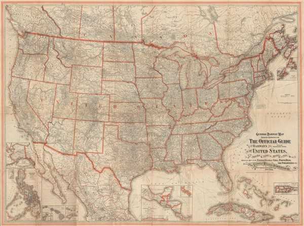
General Railway Map Engraved Expressly for The Official Guide of the Railways and Steam Navigation Lines, of the United States, Porto Rico, Canada, Mexico, and Cuba. Comprising Maps of the United States, Cuba, Porto Rico, the Philippines, etc.
1918 (dated) 40 x 53.5 in (101.6 x 135.89 cm) 1 : 3850000
1918 (dated) 40 x 53.5 in (101.6 x 135.89 cm) 1 : 3850000
Description
This is a 1918 National Railway Publication Company railway map of the United States, Canada, Mexico, Cuba, and the Philippines. The map depicts North America from southern Canada to Mexico City and from the Pacific to the Atlantic. As a highly detailed railway map, myriad cities and towns are labeled from coast to coast, as well as in Canada, Mexico, Puerto Rico, Cuba, Alaska, Hawaii, and the Philippines. Mountain ranges and rivers are also labeled. Steamship lines are depicted throughout, going to Europe, South America, the Caribbean, Asia, and Australia. It is noted that for steamship schedules, one should refer to the Official Guide. The Panama Canal features prominently, as it is noted which lines will utilize the canal. An inset map along the bottom border depicts Central America and labels the Panama Canal. A profile view of the canal is also included. Several other inset maps are located along the borders of the map, including Hawaii, Guam, Samoa, the Philippines, Alaska, and Puerto Rico. The Bahamas are depicted as well, just off the coast of Florida in the Caribbean.
This map was engraved and printed at the Matthews-Northrup Works, in Buffalo, New York and published by the National Railway Publication Company of New York, New York.
This map was engraved and printed at the Matthews-Northrup Works, in Buffalo, New York and published by the National Railway Publication Company of New York, New York.
Cartographer
Matthews-Northrup Works (fl. c. 1895 - 1930) were a Buffalo, New York based, in their own words, "writing, designing, engraving, printing, [and] binding" firm. The firm was founded by James Newson Matthews (November 21, 1828 - December 20, 1888) as the J. N. Matthews Company. William Phelps Northrup (April 2, 1850 - February 2, 1929) later joined the company as an apprentice and then partner, at which point the firm was reincorporated as the Matthews-Northrup Works. The Matthews-Northrup Works rose to prominence as publishers and printers of railroad maps, with dozens to their credit. When James died, his shares were inhered by George Edward Matthews (1855 - 1910), who ran the business until his death in 1910. Also in 1910, they famously redesigned the cover of National Geographic Magazine. Despite some six previous cover changes in just 21 years, the Matthews-Northrup layout proved so popular that it was used for nearly 50 years. The firm can also take credit for the Winchell typeface, designed in 1903 under E. E. Winchell's tenure as art director. Curiously, the partners of Matthews-Northrup maintained an unusual affectation in which only the officers of the company could wear beards or mustaches. In this same spirit, the firm also had its own private social club, the Fellowcraft Club, where the all-male employees could relax, play pool, drink and dine. Matthews-Northrup maintained offices on Washington Street, Buffalo, where they were based, as well as Madison Square, New York City, Garden Tower, Boston, and the Citizens Building in Cleveland. More by this mapmaker...
Condition
Good. Backed on archival tissue for stability. Blank on verso.
References
OCLC 67517604.