Digital Image: 1948 Survey of Ghana Folding Road Map of the Gold Coast
GoldCoastSouth-surveyofghana-1948_d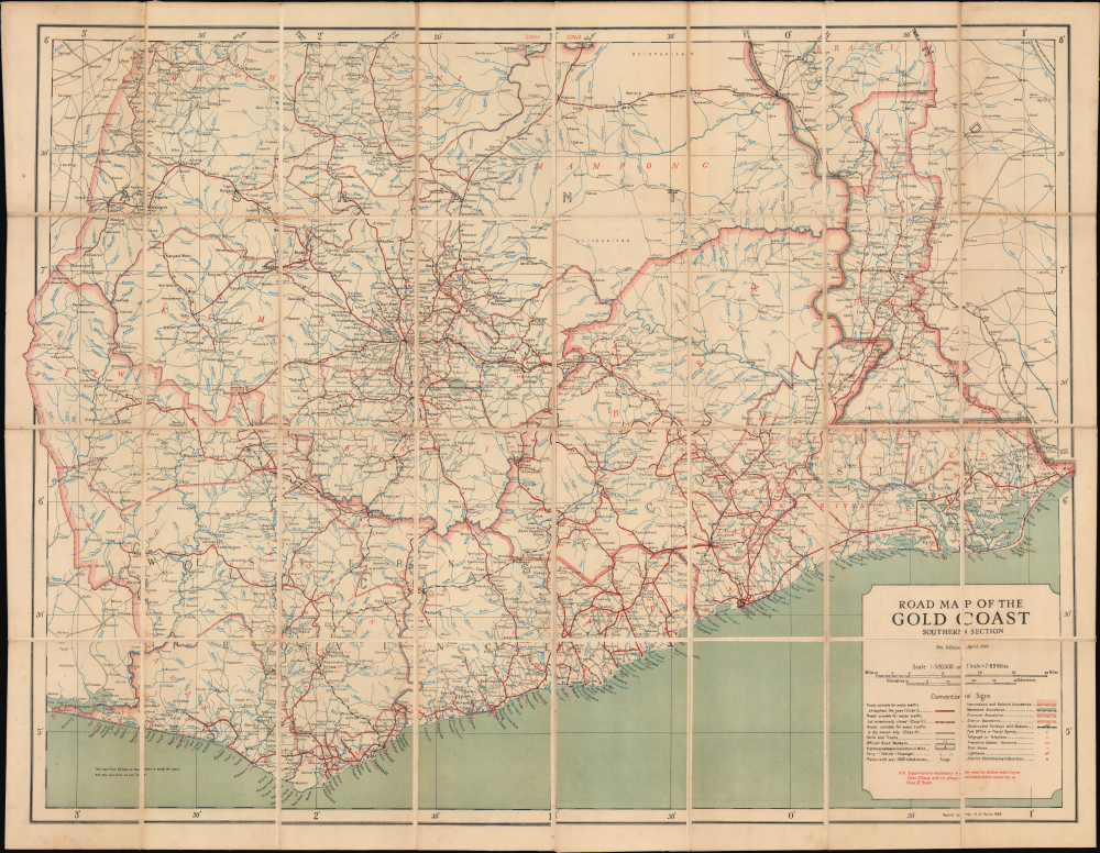


Title
Road Map of the Gold Coast Southern Section.
1948 (dated) 30.75 x 40.75 in (78.105 x 103.505 cm) 1 : 500000
1948 (dated) 30.75 x 40.75 in (78.105 x 103.505 cm) 1 : 500000
Description
FOR THE ORIGINAL ANTIQUE MAP, WITH HISTORICAL ANALYSIS, CLICK HERE.
Digital Map Information
Geographicus maintains an archive of high-resolution rare map scans. We scan our maps at 300 DPI or higher, with newer images being 600 DPI, (either TIFF or JPEG, depending on when the scan was done) which is most cases in suitable for enlargement and printing.
Delivery
Once you purchase our digital scan service, you will receive a download link via email - usually within seconds. Digital orders are delivered as ZIP files, an industry standard file compression protocol that any computer should be able to unpack. Some of our files are very large, and can take some time to download. Most files are saved into your computer's 'Downloads' folder. All delivery is electronic. No physical product is shipped.
Credit and Scope of Use
You can use your digial image any way you want! Our digital images are unrestricted by copyright and can be used, modified, and published freely. The textual description that accompanies the original antique map is not included in the sale of digital images and remains protected by copyright. That said, we put significant care and effort into scanning and editing these maps, and we’d appreciate a credit when possible. Should you wish to credit us, please use the following credit line:
Courtesy of Geographicus Rare Antique Maps (https://www.geographicus.com).
How Large Can I Print?
In general, at 300 DPI, you should at least be able to double the size of the actual image, more so with our 600 DPI images. So, if the original was 10 x 12 inches, you can print at 20 x 24 inches, without quality loss. If your display requirements can accommodate some loss in image quality, you can make it even larger. That being said, no quality of scan will allow you to blow up at 10 x 12 inch map to wall size without significant quality loss. For more information, it is best consult a printer or reprographics specialist.
Refunds
If the high resolution image you ordered is unavailable, we will fully refund your purchase. Otherwise, digital images scans are a service, not a tangible product, and cannot be returned or refunded once the download link is used.
Cartographer
The Gold Coast Survey Department / Survey of Ghana (c. 1901 - 1957) was the cartographic wing of the British colonial administration of the Gold Coast, now Ghana. The Survey's origins can be traced back to one remarkable man, George Ekem Ferguson (July 14, 1864 - April 7, 1897), who had mixed Scottish, Dutch, and African (Fante) ancestry. He received an education typical of British colonials residing in the Gold Coast, attending Wesleyan schools, before joining the colonial civil service at age seventeen and quickly showed a special aptitude for mapmaking. Beginning in 1884, he was tasked with creating maps for a variety of purposes relating to public works, mining, and boundary demarcation. He did so by working with existing maps held by the British bureaucracy, but also by talking to local people to supplement the (often quite limited) British knowledge of certain areas, especially on the frontiers of their colony. Recognizing his unique abilities (he spoke several languages common in the Gold Coast colony), the colonial government sent Ferguson in 1889 to London to be formally trained in surveying at the Royal School of Mines and the Royal Geographic Society. Unfortunately, in 1897, Ferguson was killed in the borderlands of the Gold Coast colony by soldiers of Samori Touré (c. 1828 - 1900), an aspiring leader of an anti-colonial alliance in West Africa. After Ferguson's death, the colony's need for skilled surveyors only increased and in 1901 the Gold Coast Mines Survey Department was founded, and was quickly overwhelmed with work demarcating plots for the colony's lucrative mining and timber concessions. Much of the staff of the department was African, including some of the trained surveyors (though some directors were more reluctant than others in hiring 'native' surveyors), but in any event the survey relied on locals for all manner of logistics and communication. After the First World War, the Survey changed its name to the Gold Coast Survey Department and the number of 'native' surveyors increased, aided by the establishment of a surveying school in the colony in 1921 (one had already existed for some time in southern Nigeria, but heads of the Survey had preferred locals without training to trained outsiders given the importance of interacting with the local population when surveying). With more employees, especially natives and Brits born and raised in the colony, and better training, the quantity and quality of the Survey's work increased considerably. The Great Depression and the Second World War were setbacks to the Survey's work, but it rebounded in the postwar period, when 'Africanization' policies were also adopted to promote Africans to senior leadership roles, which eased the transition to the survey operating under an independent Ghanian government (from 1957 it was officially called the 'Survey of Ghana' though this had already been an alternate name for the Gold Coast Survey Department for some time). (For more information, see McGowan, J., ' Uncovering the Roles of African Surveyors and Draftsmen in Mapping the Gold Coast, 1874–1957' in Ackerman (ed.) Decolonizing the Map: Cartography from Colony to Nation (Chicago: University of Chicago Press, 2017). More by this mapmaker...