This item has been sold, but you can get on the Waitlist to be notified if another example becomes available, or purchase a digital scan.
1948 Survey of Ghana Folding Road Map of the Gold Coast
GoldCoastSouth-surveyofghana-1948$350.00


Title
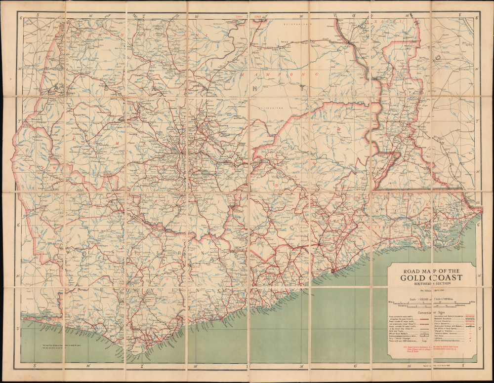
Road Map of the Gold Coast Southern Section.
1948 (dated) 30.75 x 40.75 in (78.105 x 103.505 cm) 1 : 500000
1948 (dated) 30.75 x 40.75 in (78.105 x 103.505 cm) 1 : 500000
Description
This is a 1948 Gold Coast Survey Department / Survey of Ghana large-format folding map of the southern portion of the British Gold Coast colony, the predecessor to the modern-day nation-state of Ghana. The map reflects power struggles associated with the waning days of British Colonialism in Ghana.
These tensions erupted on February 28, 1948, when a protest by ex-servicemembers in Accra was broken up by police, leaving two of the demonstrators dead. Rioting and looting broke out in Accra and elsewhere and lasted for five days before the strict imposition of curfews and censorship tamped down the unrest. In retrospect, these riots are considered the beginning of the end of British rule in the Gold Coast. But at the time, the riots were followed by British investigations and efforts to ameliorate the situation.
Yet another constitution was promulgated in 1951, granting the native population widespread political representation and a fairly broad degree of autonomy. Around this time, the Convention People's Party (CPP) led by Kwame Nkrumah (1909 - 1972) emerged as a major political force, pushing for full self-government. Finally, another constitution in 1954 shifted even further towards a self-governing, popularly-elected legislature, though a British governor remained for issues pertaining to defense and diplomacy. However, this phase was short-lived, and the Gold Coast colony achieved full independence as Ghana in March 1957.
A Closer Look
Coverage includes the Gold Coast province, the southernmost province of the British colony of Gold Coast, as well as a portion of Ashanti province. International boundaries between colonies, provincial and district boundaries within the Gold Coast colony, and 'mandated boundaries,' referring to the former German Togoland, divided between France and Britain by a League of Nations mandate after the First World War; the southernmost portion of British Togoland appears at right (it was administered as part of the Gold Coast colony). Roads of three different classes are numbered and have their distances included. Paths, tracks, ferries, rest houses, customs stations, railways, railway stations, post offices, and other features, are noted according to the legend at the bottom-right. Settlements ranging from cities to villages are indicated in great detail, along with topographic features such as rivers and streams.Waning Days of British Colonialism
Historically confined to coastal forts and trading posts, the British ruled the Gold Coast colony indirectly through local chiefs, even after a series of grinding conflicts against the powerful Ashanti Empire. By the 1920s, a new political force emerged - educated Africans (some educated in Britain and well-familiar with the British system) disdainful of the traditional chiefs and their power structures. The lobbying of these educated urbanites helped usher in a constitution in 1925 that created a Legislative Council but still effectively ruled through a handful of chiefs. After World War II (1939 - 1945), returning veterans and political activists pushed for a reformed constitution, which was promulgated in 1946. Nonetheless, discontent remained widespread, with inflation, unemployment, and shortages causing severe economic strain.These tensions erupted on February 28, 1948, when a protest by ex-servicemembers in Accra was broken up by police, leaving two of the demonstrators dead. Rioting and looting broke out in Accra and elsewhere and lasted for five days before the strict imposition of curfews and censorship tamped down the unrest. In retrospect, these riots are considered the beginning of the end of British rule in the Gold Coast. But at the time, the riots were followed by British investigations and efforts to ameliorate the situation.
Yet another constitution was promulgated in 1951, granting the native population widespread political representation and a fairly broad degree of autonomy. Around this time, the Convention People's Party (CPP) led by Kwame Nkrumah (1909 - 1972) emerged as a major political force, pushing for full self-government. Finally, another constitution in 1954 shifted even further towards a self-governing, popularly-elected legislature, though a British governor remained for issues pertaining to defense and diplomacy. However, this phase was short-lived, and the Gold Coast colony achieved full independence as Ghana in March 1957.
Publication History and Census
This map was prepared by the Gold Coast Survey Department (also known as the Survey of Ghana) in 1948. It is the 10th edition of the map, and an accompanying 'northern section' road map for the colony was also produced; some catalog listings combine the two maps. In any event, the present edition is not cataloged in the OCLC, while the April 1949 edition is held by Stanford University, the University of Wisconsin Milwaukee, and the British Library.Cartographer
The Gold Coast Survey Department / Survey of Ghana (c. 1901 - 1957) was the cartographic wing of the British colonial administration of the Gold Coast, now Ghana. The Survey's origins can be traced back to one remarkable man, George Ekem Ferguson (July 14, 1864 - April 7, 1897), who had mixed Scottish, Dutch, and African (Fante) ancestry. He received an education typical of British colonials residing in the Gold Coast, attending Wesleyan schools, before joining the colonial civil service at age seventeen and quickly showed a special aptitude for mapmaking. Beginning in 1884, he was tasked with creating maps for a variety of purposes relating to public works, mining, and boundary demarcation. He did so by working with existing maps held by the British bureaucracy, but also by talking to local people to supplement the (often quite limited) British knowledge of certain areas, especially on the frontiers of their colony. Recognizing his unique abilities (he spoke several languages common in the Gold Coast colony), the colonial government sent Ferguson in 1889 to London to be formally trained in surveying at the Royal School of Mines and the Royal Geographic Society. Unfortunately, in 1897, Ferguson was killed in the borderlands of the Gold Coast colony by soldiers of Samori Touré (c. 1828 - 1900), an aspiring leader of an anti-colonial alliance in West Africa. After Ferguson's death, the colony's need for skilled surveyors only increased and in 1901 the Gold Coast Mines Survey Department was founded, and was quickly overwhelmed with work demarcating plots for the colony's lucrative mining and timber concessions. Much of the staff of the department was African, including some of the trained surveyors (though some directors were more reluctant than others in hiring 'native' surveyors), but in any event the survey relied on locals for all manner of logistics and communication. After the First World War, the Survey changed its name to the Gold Coast Survey Department and the number of 'native' surveyors increased, aided by the establishment of a surveying school in the colony in 1921 (one had already existed for some time in southern Nigeria, but heads of the Survey had preferred locals without training to trained outsiders given the importance of interacting with the local population when surveying). With more employees, especially natives and Brits born and raised in the colony, and better training, the quantity and quality of the Survey's work increased considerably. The Great Depression and the Second World War were setbacks to the Survey's work, but it rebounded in the postwar period, when 'Africanization' policies were also adopted to promote Africans to senior leadership roles, which eased the transition to the survey operating under an independent Ghanian government (from 1957 it was officially called the 'Survey of Ghana' though this had already been an alternate name for the Gold Coast Survey Department for some time). (For more information, see McGowan, J., ' Uncovering the Roles of African Surveyors and Draftsmen in Mapping the Gold Coast, 1874–1957' in Ackerman (ed.) Decolonizing the Map: Cartography from Colony to Nation (Chicago: University of Chicago Press, 2017). More by this mapmaker...
Condition
Very good. Dissected and mounted on original linen.