This item has been sold, but you can get on the Waitlist to be notified if another example becomes available, or purchase a digital scan.
1680 / 1693 Hendrick Doncker Chart of the North Atlantic
Greenland-doncker-1680$750.00

Title
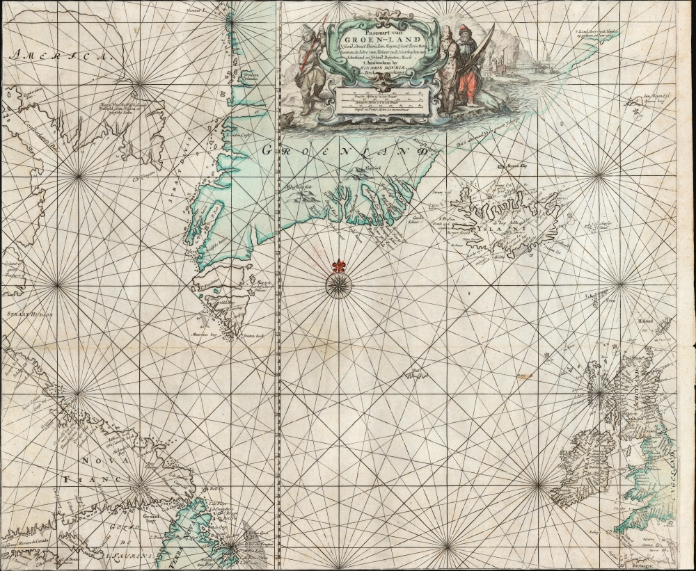
Pascaart van Groen-Land Yslandt, Straat Davis, Ian Mayen Eylant, Terra Nova, hoemen de Selve van Hitland ende Noortkusten van Schotland en Yrland Beseylen Mach.
1680 (undated) 20 x 23.5 in (50.8 x 59.69 cm) 1 : 5000000
1680 (undated) 20 x 23.5 in (50.8 x 59.69 cm) 1 : 5000000
Description
This is Hendrick Doncker's 1680 chart of the North Atlantic, in its second, 1693 state, containing the coasts of Greenland, Iceland, the British Isles, and Maritime Canada; the chart includes the Straits of Hudson, Davis, and Frobisher, reflecting the efforts over the prior century to reveal a Northwest Passage and probe the Arctic.
In a new addition appearing in this state of the chart, Iceland features depth soundings along its northern coast. Jan Mayen Island appears to the upper right. Meanwhile, in the lower right the British Isles and the northern coast of Brittany connect America with Europe.
A Closer Look
The chart, set around an elegant central compass rose amongst a network of rhumb lines, is focused on the span of the Atlantic between the British Isles and Canada, bounded by Greenland and the Arctic to the north. In the lower left is the mouth of the St. Lawrence River (Le Grand Riviere de Canada) and the Gulf of St. Lawrence. This includes the coasts of Labrador (Nova Francia) and Newfoundland (Terra Nova). Resolution Island (Island of Good Fortune) appears to the north. The upper left incorporates part of the coast of Baffin Island, here simply termed 'America'. The Cumberland Sound is named. A note in Dutch indicates that here can be found 'various fresh fish, dead whales, white foxes, and fresh salmon'. Dominating the chart at top center is Greenland, whose bays and fjords remained poorly understood. The single bay misidentified as a strait in the 16th century by Martin Frobisher has here become two separate passages. A long stretch of Greenland's east coast is sketched in with the note that 'this is all ice and great icebergs.' Preserved exclusively in charts of this era, a further passage at Greenland's extreme northeast describes 'the land through which Gaal Hamkes went in the year 1654'.In a new addition appearing in this state of the chart, Iceland features depth soundings along its northern coast. Jan Mayen Island appears to the upper right. Meanwhile, in the lower right the British Isles and the northern coast of Brittany connect America with Europe.
An Uncatchable Bus
The chart - and its forbears, going back to 1649 illustrate the phantom island of Bus. This island was first recorded during the 1578 third Frobisher expedition by sailors aboard the ship Emanuel of Bridgwater. The Emanuel was a class of vessel known as a Busse, and its crew named the island for the type of vessel that its discoverers used. Today, it is generally believed that the sighting resulted from misinterpreted optical effects. This did not prevent 'Thomas Shepard' from claiming in 1671 to have explored the island. Navigators failed to discover Bus in the subsequent centuries despite the increase of Atlantic traffic in the 18th century: this resulted in later maps adjusting the supposed size of the island down until its location was labeled 'site of the sunken island' on some 19th-century charts. In 1818, during his first Arctic expedition, John Ross sought the sunken island; finding no depth at 180 fathoms at the appropriate location, he concluded that it never existed.Decorative Engraving
At top center is an elegant shell-work cartouche, flanked by figures in the garb of Arctic whale fishers; the one to the left brandishes a harpoon; two to the right appear to be discussing the merits of a very small kayak. In the background, workers labor at various stages of whaling and processing blubber: the primary focus of most Dutch activity in these northern seas.The State of the Art
The charting of the north parts of the world had been a major focus of explorers and mapmakers from the end of the 16th century through the 19th, and this area showed marked cartographic development during the period leading up to Doncker's chart. The formulation of Baffin Island, Greenland, Iceland, and Jan Mayen Island first appeared in 1649 on Theunis Jacobsz' similarly-titled Pascaarte van Groenland, Yslandt, Hitlandt, Straet-Davids als mede Ian Mayen Eylandt; Pieter Goos produced an expanded version including the British Isles in 1650, which served Doncker as the basis for an early 1659 plate of this map. (The 1659 plate, among other features, lacked Buss Island.)Publication History and Census
This chart was engraved for inclusion in Hendrick Doncker's 1680 De Nieuwe Groote Vermeerdede Zee-Atlas ofte Water-Werelt. The present example, produced for the 1693 edition of the Zee-Atlas was revised with a new delineation for the Grand Bank near Newfoundland and depth soundings along the northern Iceland. The chart is rare: only three examples of the separate chart are cataloged in OCLC: at the Biblioteca Nacional de Espana (1680, 1693) and Universiteit Van Amsterdam (1693).CartographerS
Hendrick Doncker (1626 - 1699) (a.k.a. Henri Donker) was a Dutch bookseller and publisher of sea charts and nautical atlases active in Amsterdam during the middle part of the 17th century. He maintained a presence on Nieuwe Brugsteeg, Amsterdam. He married Elizabeth Abrahamsd Rensing in 1647. Doncker was somewhat unique to this period in that he did not copy the work of earlier cartographers, instead producing his own map. Moreover, Doncker's charts were widely admired for their constant revision and overall accuracy. In addition to producing his own charts, he also collaborated with Pieter Goos and Anthonie Jacobsz to producing the pilot guide De Zeespiegel. Following his 1699 death, Doncker's remaining stock and valuable map plates were acquired by Johannes van Keulen. He was survived by a daughter, Anna Doncker. More by this mapmaker...
Pieter Goos (1616 - 1675) was a Dutch cartographer, engraver, publisher and bookseller. Goos was born in Amsterdam, the son of cartographer, globemaker, and engraver Abraham Goos (1590 - 1643). Goos followed in his father's footsteps as a mapmaker and engraver, working with Petrus Kaerius, C.J. Visscher, John Speed, Henricus Hondius, and Johannes Janssonius, among others. Goos began publishing on his own account in 1657 and, from 1666, began issuing a series of well-received nautical atlases. His De Zee-Atlas Ofte Water-Wereld is considered one of the most extraordinary maritime atlases of the Dutch Golden Age. His most famous and elusive atlas, however, was 'The Burning Fen,' Het brandende veen verlichtende de kust van Africa ende America, a collaboration with the mathematician Arent Roggeveen (1658 - 1679). When Goos died in 1675, his widow, Margareta van den Keere, sold his copper printing plates to the publisher Jacobus Robijn (c. 1649 - 1707), who reissued many of them. Learn More...
Source
Doncker, H., Nieuwe Groote Vermeerderde Zee-Atlas ofte Water-Werelt, (Amsterdam: Doncker) 1693.
Condition
Very good. Trimmed to neatline on top, left and bottom with virtually no loss. Scuffing to bottom corners. Original hand color.
References
OCLC 754402499. cf. Burden, P., The Mapping of North America, #337 (1659 plate)