Digital Image: 1680 / 1693 Hendrick Doncker Chart of the North Atlantic
Greenland-doncker-1680_d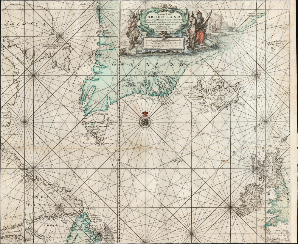

Title
Pascaart van Groen-Land Yslandt, Straat Davis, Ian Mayen Eylant, Terra Nova, hoemen de Selve van Hitland ende Noortkusten van Schotland en Yrland Beseylen Mach.
1680 (undated) 20 x 23.5 in (50.8 x 59.69 cm) 1 : 5000000
1680 (undated) 20 x 23.5 in (50.8 x 59.69 cm) 1 : 5000000
Description
FOR THE ORIGINAL ANTIQUE MAP, WITH HISTORICAL ANALYSIS, CLICK HERE.
Digital Map Information
Geographicus maintains an archive of high-resolution rare map scans. We scan our maps at 300 DPI or higher, with newer images being 600 DPI, (either TIFF or JPEG, depending on when the scan was done) which is most cases in suitable for enlargement and printing.
Delivery
Once you purchase our digital scan service, you will receive a download link via email - usually within seconds. Digital orders are delivered as ZIP files, an industry standard file compression protocol that any computer should be able to unpack. Some of our files are very large, and can take some time to download. Most files are saved into your computer's 'Downloads' folder. All delivery is electronic. No physical product is shipped.
Credit and Scope of Use
You can use your digial image any way you want! Our digital images are unrestricted by copyright and can be used, modified, and published freely. The textual description that accompanies the original antique map is not included in the sale of digital images and remains protected by copyright. That said, we put significant care and effort into scanning and editing these maps, and we’d appreciate a credit when possible. Should you wish to credit us, please use the following credit line:
Courtesy of Geographicus Rare Antique Maps (https://www.geographicus.com).
How Large Can I Print?
In general, at 300 DPI, you should at least be able to double the size of the actual image, more so with our 600 DPI images. So, if the original was 10 x 12 inches, you can print at 20 x 24 inches, without quality loss. If your display requirements can accommodate some loss in image quality, you can make it even larger. That being said, no quality of scan will allow you to blow up at 10 x 12 inch map to wall size without significant quality loss. For more information, it is best consult a printer or reprographics specialist.
Refunds
If the high resolution image you ordered is unavailable, we will fully refund your purchase. Otherwise, digital images scans are a service, not a tangible product, and cannot be returned or refunded once the download link is used.
Cartographer S
Hendrick Doncker (1626 - 1699) (a.k.a. Henri Donker) was a Dutch bookseller and publisher of sea charts and nautical atlases active in Amsterdam during the middle part of the 17th century. He maintained a presence on Nieuwe Brugsteeg, Amsterdam. He married Elizabeth Abrahamsd Rensing in 1647. Doncker was somewhat unique to this period in that he did not copy the work of earlier cartographers, instead producing his own map. Moreover, Doncker's charts were widely admired for their constant revision and overall accuracy. In addition to producing his own charts, he also collaborated with Pieter Goos and Anthonie Jacobsz to producing the pilot guide De Zeespiegel. Following his 1699 death, Doncker's remaining stock and valuable map plates were acquired by Johannes van Keulen. He was survived by a daughter, Anna Doncker. More by this mapmaker...
Pieter Goos (1616 - 1675) was a Dutch cartographer, engraver, publisher and bookseller. Goos was born in Amsterdam, the son of cartographer, globemaker, and engraver Abraham Goos (1590 - 1643). Goos followed in his father's footsteps as a mapmaker and engraver, working with Petrus Kaerius, C.J. Visscher, John Speed, Henricus Hondius, and Johannes Janssonius, among others. Goos began publishing on his own account in 1657 and, from 1666, began issuing a series of well-received nautical atlases. His De Zee-Atlas Ofte Water-Wereld is considered one of the most extraordinary maritime atlases of the Dutch Golden Age. His most famous and elusive atlas, however, was 'The Burning Fen,' Het brandende veen verlichtende de kust van Africa ende America, a collaboration with the mathematician Arent Roggeveen (1658 - 1679). When Goos died in 1675, his widow, Margareta van den Keere, sold his copper printing plates to the publisher Jacobus Robijn (c. 1649 - 1707), who reissued many of them. Learn More...
Source
Doncker, H., Nieuwe Groote Vermeerderde Zee-Atlas ofte Water-Werelt, (Amsterdam: Doncker) 1693.
References
OCLC 754402499. cf. Burden, P., The Mapping of North America, #337 (1659 plate)