Digital Image: 1818 Chapman Map or Plan of Bunker Hill, Charlestown, Massachusetts
HeightsOfCharlestown-chapman-1818_d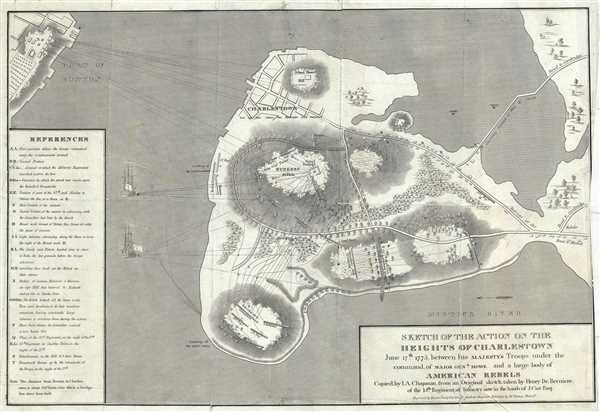

Title
Sketch of the Action on the Heights of Charlestown June 17th 1775 between his Majesty's Troops under the command of Major Genl. Howe, and a Large Body of American Rebels.
1818 (undated) 13 x 20 in (33.02 x 50.8 cm)
1818 (undated) 13 x 20 in (33.02 x 50.8 cm)
Description
FOR THE ORIGINAL ANTIQUE MAP, WITH HISTORICAL ANALYSIS, CLICK HERE.
Digital Map Information
Geographicus maintains an archive of high-resolution rare map scans. We scan our maps at 300 DPI or higher, with newer images being 600 DPI, (either TIFF or JPEG, depending on when the scan was done) which is most cases in suitable for enlargement and printing.
Delivery
Once you purchase our digital scan service, you will receive a download link via email - usually within seconds. Digital orders are delivered as ZIP files, an industry standard file compression protocol that any computer should be able to unpack. Some of our files are very large, and can take some time to download. Most files are saved into your computer's 'Downloads' folder. All delivery is electronic. No physical product is shipped.
Credit and Scope of Use
You can use your digial image any way you want! Our digital images are unrestricted by copyright and can be used, modified, and published freely. The textual description that accompanies the original antique map is not included in the sale of digital images and remains protected by copyright. That said, we put significant care and effort into scanning and editing these maps, and we’d appreciate a credit when possible. Should you wish to credit us, please use the following credit line:
Courtesy of Geographicus Rare Antique Maps (https://www.geographicus.com).
How Large Can I Print?
In general, at 300 DPI, you should at least be able to double the size of the actual image, more so with our 600 DPI images. So, if the original was 10 x 12 inches, you can print at 20 x 24 inches, without quality loss. If your display requirements can accommodate some loss in image quality, you can make it even larger. That being said, no quality of scan will allow you to blow up at 10 x 12 inch map to wall size without significant quality loss. For more information, it is best consult a printer or reprographics specialist.
Refunds
If the high resolution image you ordered is unavailable, we will fully refund your purchase. Otherwise, digital images scans are a service, not a tangible product, and cannot be returned or refunded once the download link is used.
Cartographer S
Henry de Berniere (17?? - 1800) was an ensign and spy in the British Army’s 14th Regiment. Under the command of British General Gage, Captain William Brown and Berniere would disguise themselves as farmers or workers in civilian clothes and venture into the countryside and towns to spy on American battle preparations. Berniere, an artist, would sketch details of the area, and Brown was the logistics expert. They were responsible for helping British troops attack Concord in April 1775. More by this mapmaker...
The Analectic Magazine (1813-1820), was published by Moses Thomas in Philadelphia. The July 1819 issue of the magazine featured the first lithograph ever made in America, depicting a woodland scene by Bass Otis. Famous American author, essayist and historian served at editor of the magazine from 1813- 1814. He also reprinted Francis Scott Key’s poem ‘ Defense of Fort McHenry’ in November 1814 edition of the Analectic Magazine, later immortalized as the United States national anthem ‘The Star-Spangled Banner’. Learn More...
References
OCLC 5566881. Sabin, J., A dictionary of books relating to America: from its discovery to the present time, 12122.