This item has been sold, but you can get on the Waitlist to be notified if another example becomes available, or purchase a digital scan.
1879 C. R. Markham Map of Afghanistan and Pakistan
HelmundRiver-stanford-1879$75.00

Title
The Helmund River.
1879 (dated) 17 x 14 in (43.18 x 35.56 cm) 1 : 1584000
1879 (dated) 17 x 14 in (43.18 x 35.56 cm) 1 : 1584000
Description
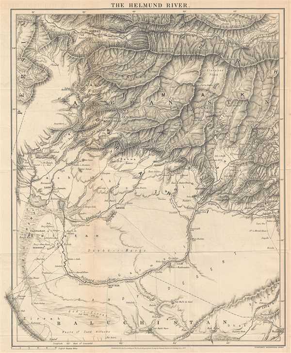
This is a rare 1879 Sir Clements Robert Markham map of Afghanistan and Pakistan. This map illustrates southwestern Afghanistan and northwestern Pakistan (Baluchistan) and parts of extreme eastern Iran (Persia), including the Hindu Kush (Koh-i-Baba), the Sadif-Koh (White mountains), the Siah-Koh, the Paghman range, the Gul-Koh, the Toba, and Khoja-Amran mountains. This is a very detailed map and details the topography of the region beautifully. The map traces the route of the Helmand (Helmund) River, which is shown prominently in the lower third of the map. Other rivers are labeled and roads are shown. Kandahar is on the lower right at the foot of the mountains. Most of the mountain ranges are labeled.
Markham described the region thus,
Markham described the region thus,
The western portion of Afghanistan, which includes the inland basin of the River Helmund, and the smaller inland basin of the Abistada Lake. It is comprised in one of those river systems without any outlet to the sea, which occupy a vast area in the interior of Asia, where the drainage flowing from a circle or semicircle of mountains is formed into a lake or morass at the lowest level it can reach. Such are the basins of the Caspian and the Aral, of the Balkhash and Baikal, of Lake Lob and the Tibetan Plateau, and of the Helmund and the Abistada Lake …This map accompanied C.R. Markham's paper 'The Basin of the Helmud' in the Proceedings of the Royal Geographical Society and Monthly Record of Geography,Vol. 1, No.3. It was published by Stanford's Geographical Establishment.
Cartographer
Edward Stanford (May 27, 1827 - November 3, 1904) was one of the most prolific map publishing firms of the late 19th century. The company began as a partnership in 1848 between the 21 year old Edward Stanford and the established map dealer Trelawney Saunders. By 1853 the partnership had dissolved and Edward Stanford took full control of the business. A subsequent series of expansions and exciting new map issues finally led to the production of Stanford's masterwork, "Stanford's Library Map of London". This map is still available and remains somewhat accurate. At the time of publishing it was hailed by the Royal Geographical Society as "the most perfect map of London that has ever been issued". In 1882 Edward Stanford Sr. passed the firm on to his son, Edward Stanford Jr. who continued in his father's proud tradition. Today the Stanford firm still publishes maps and remains one of the most important and prolific cartographic publishers in the world. More by this mapmaker...
Source
Markham, C.R., The Basin of the Helmund, in Proceedings of the Royal Geographical Society and Monthly Record of Geography Vol.1, No. 3, March 1879.
Condition
Very good. Some wear along original fold lines. Light transference. Blank on verso
References
OCLC 557678605.