1949 Shane / Leno Pictorial Map of Warm Springs Indian Reservation, Oregon
HistoReliefWarmSprings-shane-1949$750.00

Title
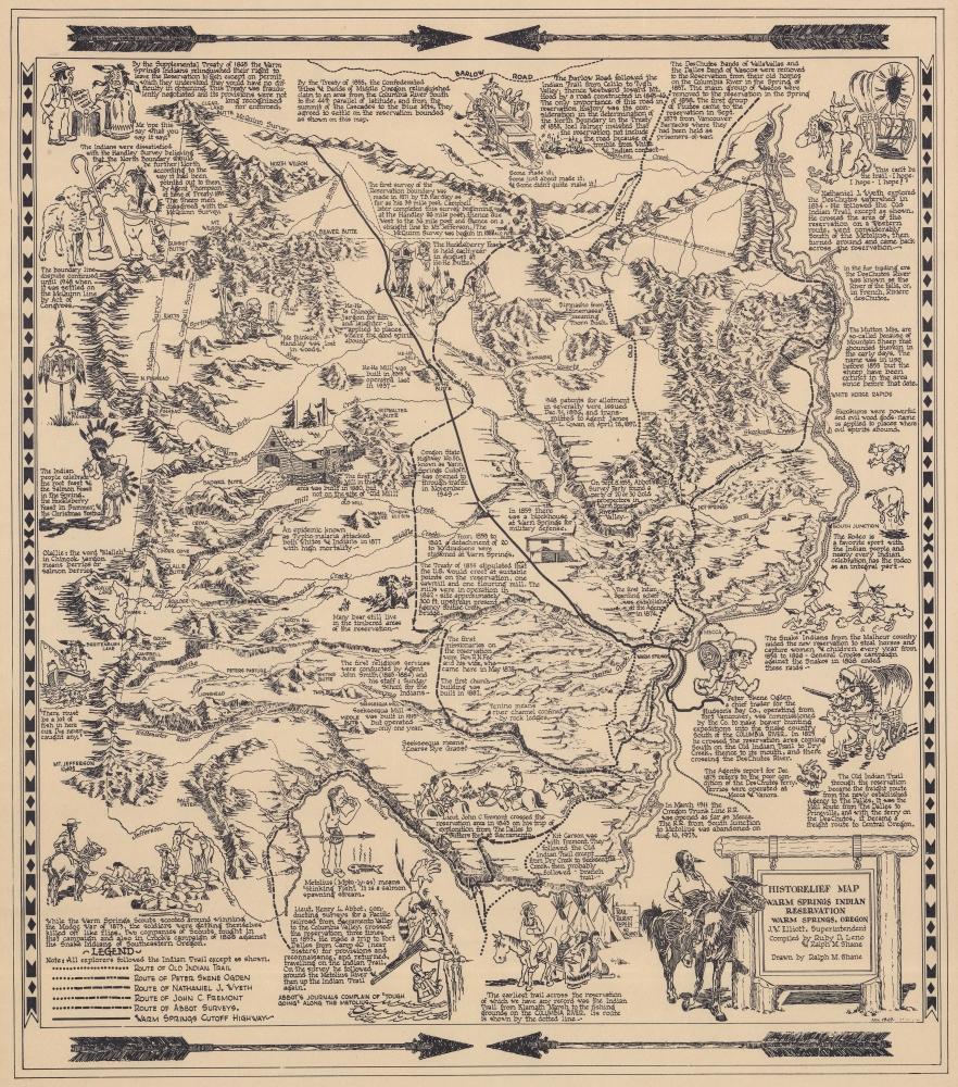
HistoRelief Map of Warm Springs Indian Reservation Warm Springs, Oregon.
1949 (dated) 17.5 x 15.5 in (44.45 x 39.37 cm)
1949 (dated) 17.5 x 15.5 in (44.45 x 39.37 cm)
Description
This is a 1949 pictorial map of the Warm Springs Indian Reservation, Oregon, compiled by Indian Agents Ralph M. Shane and Ruby D. Leno of the Upper Chinook Tribe. Pictorial vignettes highlight historical events, Native American culture, frontier life, and the conflicts between white settlers and Native Americans.
A Closer Look
Shane and Leno beautifully illustrate Warm Springs' striking topography, brilliantly rendering mountain ranges, buttes, and river valleys. Illustrations depict mills constructed by the U.S. government, explorers trekking through the area, and historical moments, such as the signing of the Supplemental Treaty of 1865. Dotted and dashed lines trace the McQuinn Survey, Campbell Survey, and Handley Survey, which played a role in establishing the reservation's boundaries. Bold lines follow the Old Indian Trail and the routes of Nathaniel J., Wyeth, Peter Skene Ogden, and John C. Fremont through the region and the Warm Springs Cutoff Highway.Warm Springs Reservation
Established in the mid-19th century, the Warm Springs Indian Reservation is home to the Confederated Tribes of Warm Springs, comprising the Wasco, Warm Springs, and Paiute tribes. Originally occupying vast territories across the Columbia Plateau, these tribes were forcibly relocated to the reservation in the 1850s, following treaties with the United States government. Spanning over 1,000 square miles of high desert landscape, this reservation holds deep cultural significance for its indigenous inhabitants. The reservation is characterized by its rugged terrain, including the iconic Cascade Mountain Range, and is blessed with natural resources like the Deschutes River, which plays a vital role in tribal life. Despite historical challenges and ongoing struggles with economic development and healthcare, the Warm Springs Reservation remains a vibrant center of Native American culture, traditions, and resilience.Publication History and Census
This map was compiled by Ruby D. Leno and Ralph M. Shane, drawn by Ralph M. Shane, and published in November 1949. We note a single cataloged example, which is part of the Native American Maps Collection, 1875 - 1972, at Oregon State University.CartographerS
Ralph M. Shane (1910 - July 12, 1984) was an artist and U.S. government engineer. Born near Edelstein, Illinois, Shane's parents moved the family to Pipestone, Minnesota, where he attended public school. After high school, Shane attended the University of Colorado before transferring to the South Dakota School of Mines, where he graduated in 1935 with a B.S. in engineering. He found work with the South Dakota State Highway Commission and drafted strip and right-of-way maps. In November 1936, Shane joined the Bureau of Indian Affairs as an engineering draftsman. He was promoted to junior road engineer the following year. The Bureau transferred him to Sacramento, California, in January 1939 to work as chief of a road survey party. Shane worked as a road engineer for the Bureau of Indian Affairs across the western United States through the 1940s and 1950s, except for a four-month furlough in 1943 when he served as a Navy ensign. He left the Bureau of Indian Affairs in 1955 and bought a newspaper in New Town, North Dakota, which he edited for two years before returning to the Bureau of Indian Affairs. He retired from the Bureau in 1979. Shane was married twice. First to Jeanette Wildman, whom he married in 1936, then to Carolyn Mae Hodgkinson, whom he married on July 14, 1944. He had four children. More by this mapmaker...
Ruby D. Leno (March 5, 1915 - March 13, 1990), née Dean, was an American Indian of the Upper Chinook of the Warm Springs Reservation, Oregon. She was born Grand Ronde, Polk County, Oregon. She worked for the Warm Spring Agency, Field Services. She worked with Indian Agent Ralph M. Shane to compile a historical map of the Warm Spring Reservation. Learn More...
Condition
Very good. Closed margin tears professionally repaired on verso.
References
Native American Maps Collection (MAPS NativeMaps), Oregon State University Special Collections and Archives Research Center, Corvallis, Oregon.