1861 Collinson Admiralty Chart or Map of Hong Kong and Vicinity
HongKongII-collinson-1861$2,200.00

Title
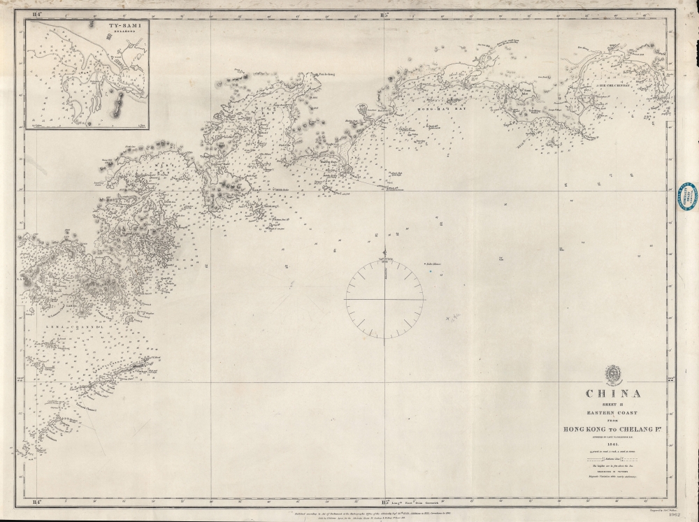
China Sheet II Eastern Coast from Hong Kong to Chelang Pt.
1861 (dated) 19.25 x 25.5 in (48.895 x 64.77 cm) 1 : 300000
1861 (dated) 19.25 x 25.5 in (48.895 x 64.77 cm) 1 : 300000
Description
A rare 1861 British Admiralty / Richard Collinson nautical map covering the coast of China around Hong Kong. It was issued shortly after the Second Opium War (1856 - 1860) and the British acquisition of Kowloon (which is labeled).
A Closer Look
Coverage embraces the China coast from Hong Kong (香港) to Chelang Point (near Jieshi Bay). It provides excellent coverage of the New Territories, although they were not then known as such, from Lan Tao (大嶼山) to Mirs Bay. The urban center of Hong Kong, Central, is here identified as Victoria. The map includes an inset of Shànwěi (汕尾), or Swabue, or Ty-Sami, in the upper left corner.Collinson Surveys the China Coast
Following the acquisition of Hong Kong at the end of the First Opium War (1839 - 1842), the British recognized the demand for detailed surveys of the China Coast. They turned to Richard Collinson, a Royal Navy officer who had distinguished himself in the War. Collinson completed detailed surveys of the China coast in the vicinity of Hong Kong between 1842 and 1846. This map (the result of those surveys) was completed in 1845, but not published until 1849. The map went through several editions until the 1880s, and the present example corresponds to the 3rd edition with updates to 1852 and corrections to 1861. It is noteworthy that the 1861 update follows closely on the 1860 acquisition of Kowloon, which is probably behind the update in that year.Publication History and Census
This map was printed by J. and C. Walker for the British Admiralty Hydrographic Office as chart number 1962. The original seller was J. D. Potter, of King Street, Tower Hill, London. It subsequently found its way to Melbourne, Australia, where it was sold by Blundell and Ford, Agents for the sale of Admiralty Charts. All examples of this chart in all editions are extremely rare. We have identified no other examples of the 1861 edition. Two examples of the 1852 chart are known, one at Brown University, and another in the National Maritime Museum, Greenwich, England.CartographerS
Richard Collinson (November 7, 1811 – September 13, 1883) was an English naval officer, marine surveyor, and Arctic explorer. He was born in Gateshead, Tyne and Wear, England, then part of Durham. He joined the Royal Navy in 1823, at age twelve, and rose in the ranks, becoming a lieutenant in 1835, commander in 1841, and captain in 1842. Collinson was a highly capable captain. He participated with distinction in the First Opium War (1839 - 1842). After the war, along with Commander Henry Kellett, he completed a series of pioneering surveys of the China coast from the Yangtze River to Hong Kong. These he completed between 1842 and 1846 while serving as commander of the HMS Plover. In 1850, he was sent north in command of the HMS Enterprise to search for survivors of the Sir John Franklin expedition. Although he came quite close, he never found Franklin's lost men and returned to England without success. Nonetheless, he was honored by the Royal Geographical Society for his surveys in the Arctic and proof that it was navigable from the Behring Strait to King William's Land. Collinson was Knighted in 1875, the same year in which he retired from active duty with the rand of Admiral. Collinson died in September of 1883. More by this mapmaker...
The British Admiralty Office (1795 - Present) or the United Kingdom Hydrographic Office refers to the Branch of the English government that is responsible for the command of the British Navy. In 1795 King George III created the United Kingdom Hydrographic Office, known in short as the U.K.H.O., to provide top notch nautical charts to the vast Royal Navy. Prior the founding of the Admiralty the surveying and creation of nautical charts was primarily a commercial venture wherein the cartographer himself, more of than not, actually financed the printing of his own material. The great navigator Cook himself is known to have scrambled for funds to publish his own seminal charts - the most important and advanced of the period. The system of privately funded nautical mapping and publishing left vast portions of the world uncharted and many excellent charts unpublished. King George III, responding significant loss in trade revenue related to shipwrecks and delay due to poor charts, recognized the need for an institutionalized government sponsored cartographic agency - the Admiralty. The first head of the Admiralty, a position known as Hydrographer, was the important cartographer Alexander Dalrymple. Dalrymple started by organizing and cataloging obtainable charts before initiating the laborious process of updating them and filling in the blanks. The first official Admiralty Chart appeared in 1800 and detailed Quiberon Bay in Brittany. By 1808 the position of Hydrographer fell to Captain Thomas Hurd. Hurd advocated the sale of Admiralty charts to the general public and, by the time he retired in 1829, had issued and published some 736 charts. Stewardship of the organization then passed to Rear Admiral Sir Francis Beaufort. It was under Beaufort's administration that the Admiralty truly developed as a "chart making" as opposed to a "chart cataloging" institution. Beaufort held his post from 1829 to 1854. In his 25 years at the Admiralty Beaufort created nearly 1500 new charts and sponsored countless surveying and scientific expeditions - including the 1831 to 1836 voyage of the H.M.S. Beagle. By 1855 the Admiralty's chart catalog listed some 1,981 charts. Learn More...
John Walker (1787 - April 19, 1873) was a British map seller, engraver, lithographer, hydrographer, geographer, draughtsman, and publisher active in London during the 19th century. Walker published both nautical charts and geographical maps. His nautical work is particularly distinguished as he was an official hydrographer for the British East India Company, a position, incidentally, also held by his father of the same name. Walker's maps, mostly published after 1827, were primarily produced with his brothers Charles Walker and Alexander Walker under the imprint J. and C. Walker. Among their joint projects are more than 200 maps for the influential Society for the Diffusion of Useful Knowledge Atlas (SDUK). In addition they published numerous charts for James Horsburgh and the British Admiralty Hydrographic Office, including Belcher's important map of Hong Kong and Carless' exploratory map of Karachi. The J. and C. Walker firm continued to publish after both Walkers died in the 1870s. Learn More...
Condition
Very good. Slight edge wear and and slight loss to edges. Light soiling along upper border.
References
OCLC 70112823. National Maritime Museum, Greenwich, London, G271:8/5.