Digital Image: 1906 Takei Nekketsu Map of Japantown, Honolulu, Hawaii
HonoluluJapantown-takei-1906_d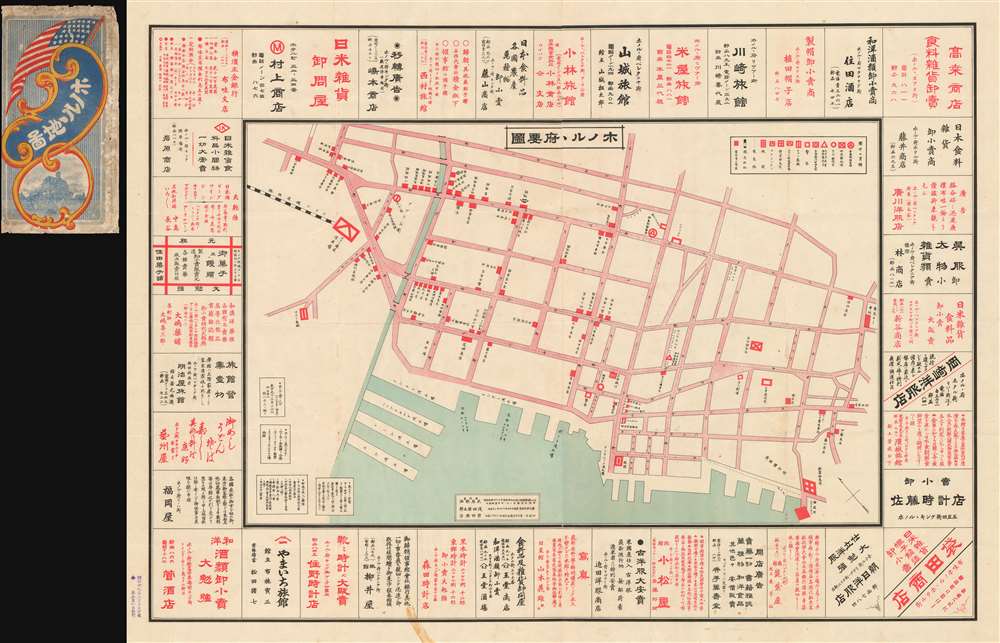

Title
Map of Honolulu. / ホノル 府要圖
1906 (dated) 30 x 40 in (76.2 x 101.6 cm)
1906 (dated) 30 x 40 in (76.2 x 101.6 cm)
Description
FOR THE ORIGINAL ANTIQUE MAP, WITH HISTORICAL ANALYSIS, CLICK HERE.
Digital Map Information
Geographicus maintains an archive of high-resolution rare map scans. We scan our maps at 300 DPI or higher, with newer images being 600 DPI, (either TIFF or JPEG, depending on when the scan was done) which is most cases in suitable for enlargement and printing.
Delivery
Once you purchase our digital scan service, you will receive a download link via email - usually within seconds. Digital orders are delivered as ZIP files, an industry standard file compression protocol that any computer should be able to unpack. Some of our files are very large, and can take some time to download. Most files are saved into your computer's 'Downloads' folder. All delivery is electronic. No physical product is shipped.
Credit and Scope of Use
You can use your digial image any way you want! Our digital images are unrestricted by copyright and can be used, modified, and published freely. The textual description that accompanies the original antique map is not included in the sale of digital images and remains protected by copyright. That said, we put significant care and effort into scanning and editing these maps, and we’d appreciate a credit when possible. Should you wish to credit us, please use the following credit line:
Courtesy of Geographicus Rare Antique Maps (https://www.geographicus.com).
How Large Can I Print?
In general, at 300 DPI, you should at least be able to double the size of the actual image, more so with our 600 DPI images. So, if the original was 10 x 12 inches, you can print at 20 x 24 inches, without quality loss. If your display requirements can accommodate some loss in image quality, you can make it even larger. That being said, no quality of scan will allow you to blow up at 10 x 12 inch map to wall size without significant quality loss. For more information, it is best consult a printer or reprographics specialist.
Refunds
If the high resolution image you ordered is unavailable, we will fully refund your purchase. Otherwise, digital images scans are a service, not a tangible product, and cannot be returned or refunded once the download link is used.
Cartographer
Takei Nekketsu (March 8, 1879 - April 22, 1961) (武居熱血) was a Japanese-Hawaiian merchant, photographer, editor, journalist, patent attorney, storyteller, and map maker based in Honolulu, Hawaii. Takei was born in Kudamatsu-shi, Yamaguchi-ken, Japan, the eldest son of a Sake manufacturer. Hailed as a child genius, he studied Chinese under Manumoto Sakyo at the Shoryu Temple, then at the Tokuyama Middle School. After the Sino Japanese War (1894 - 1895), Takei became fascinating with political and military events and began lecturing throughout Japan. Seeking greener pastures, he emigrated to Honolulu, Hawaii, arriving on December 15, 1903. With most Japanese in Hawaii at the time being poor uneducated cane farmers, the dashing, sophisticated, and highly educated Takei stood out, with trademark long hair, a large well-groomed mustache and beard, a black bower hat, and a frock coat. He continued lecturing among the Japanese diaspora in Hawaii, publicly asking such questions as 'Should Japan fight Russia?' and following up with 'This is the Way the Japanese Fought the Russians.' From about 1915, he owned a Kimono and dry goods shop, Takei Dry Goods, on the corner of River and Pauahi Streets, and later at 1319 Beretania St., then at 1423 S. King Street. During World War II he was briefly interred in California. Takei was well known to Hawaiian Japanese, among whom he traveled as a traditional storyteller and edgy political lecturer. While walking between plantations and Japanese-Hawaiian communities, he also produced uniquely historic documentary records of Japanese life in Hawaii through photographs and maps. These he compiled and published, often in Japan, emerging as the most prolific Hawaiian-Japanese writer of his time. When the first radio station KGU, launched Japanese programing, he signed up to tell his stories over the radio, a hobby he pursued for more than 10 years. He lived at 1414 Pickoe St., Honolulu and was a member of the Tenshō Kōtai Jingūkyō. More by this mapmaker...