1570 Ortelius Map of Hungary
Hungary-ortelius-1570$750.00

Title
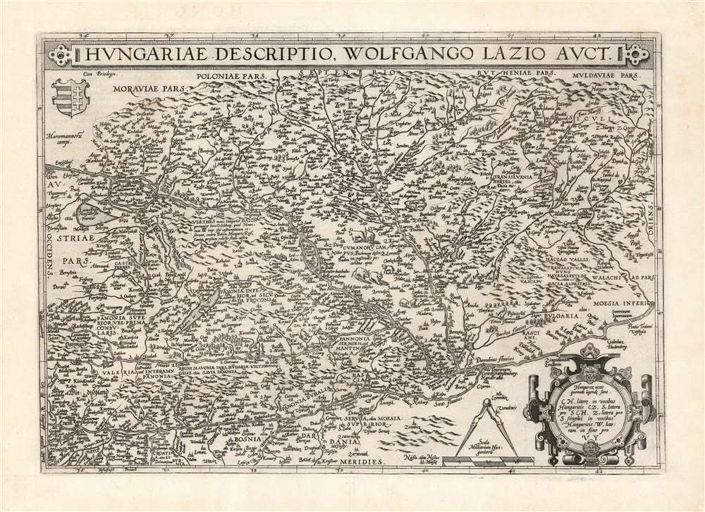
Hungariae Descriptio Wolfgango Lazio Auct.
1570 (dated) 13.75 x 19.5 in (34.925 x 49.53 cm) 1 : 1314770
1570 (dated) 13.75 x 19.5 in (34.925 x 49.53 cm) 1 : 1314770
Description
This is Abraham Ortelius' 1570 map of Hungary, the first acquirable, accurate map of that region, and the first atlas map of Hungary. The map includes parts of Austria, Slovakia and Romania, with parts of Croatia, Bosnia and Serbia in the south. The heart of the map is the River Danube, reaching from Vienna in the west to the Romanian river Olt (here in the German Alt and the Latin Aluta) Buda and Pest are shown. Belgrade appears at the confluence of the Sau and the Danube, with the antiquated German appellation Griechschweissenburg.
The Source
The map is based on Wolfgang Lazio's unacquirable 1556 Regni Hungariae Descriptio Vera, at that time the best firsthand map of the country yet produced. Ortelius was noted for his assiduous search for the best, first-hand maps he could source, and he was scrupulous in crediting his sources. Several of his maps - this one, as well as those of Austria and the Tirol - were drawn from the work of Lazio.An Evocative Engraving
The mountainous terrain is depicted pictorially, as well as the forests and the wetlands southwest of the Danube. Areas northeast of the Danube are embellished with herds of cattle - perhaps suggesting that those lands, then under Turkish domination, might be a valuable prize.Publication History and Census
This map was engraved in 1570 and was included in the first Latin editions of Ortelius' Theatrum. The plate remained in use even after Ortelius added a further map of Hungary 1579, this one derived from the 1571 work of János Zsámboky aka Johannes Sambucus. The present example conforms typographically to the 1581 French text edition, of which van den Broecke estimates there were 400 printed. It agrees with van den Broecke's fourth state, with additional stippling in lakes not evident in earlier states. Nine examples of that edition of the book are listed in OCLC. In various editions, the separate map is well represented in institutional collections.CartographerS
Abraham Ortelius (April 14, 1527 - June 28, 1598) also known as Ortels, was a cartographer, geographer, and cosmographer of Brabant, active in Antwerp. He was the creator of the first modern atlas, Theatrum Orbis Terrarum and is a seminal figure in the history of cartography. Along with Gerard Mercator and Gemma Frisius, he was a founder of the Netherlandish school of cartography. His connections with Spain - culminating in his 1575 appointment as Royal Cartographer to King Phillip II of Spain - gave him unmatched access to Spanish geographical knowledge during a crucial period of the Age of Discovery. Ortelius was born in 1527 in Antwerp. In 1547 he entered the Antwerp Guild of Saint Luke as an illuminator of maps. He began trading in books, prints, and maps, traveling regularly to the Frankfurt book and print fair, where in 1554 he met Mercator. He accompanied Mercator on journeys throughout France in 1560 and it was at this time, under Mercator's influence, that he appears to have chosen his career as a scientific geographer. His first published geographic work appeared in 1564, an eight-sheet cordiform world map. A handful of other maps preceded the 1570 publication of the first edition of the Theatrum Orbis Terrarum, which would prove to be his life work. Appearing with but 53 maps in its first edition, Ortelius' work expanded with new maps added regularly. By 1592, it had 134 maps. Many of Ortelius' maps remained the standard for nearly a century. He traveled extensively, but his genius was as a compiler, locating the best informed maps on which to base his own. His contacts throughout Europe and extending even (via the Portuguese) to the Far East were formidable. Moreover, many of his maps were based on his own scholarship, particularly his historical works. His theories of geography were particularly ahead of his time with respect to the notion of continental drift, the possibility of which he mused on as early as 1596, and which would be proven correct centuries later.
In a sense his greatest achievement was his successful navigation of the religious and political violence endemic to his city throughout his adult life: The Dutch Revolt, or Eighty Years' War (1568 - 1648), fully embroiled Antwerp. Although outwardly and officially recognized as Catholic (Arias Montanus vouched for Ortelius' Catholic orthodoxy prior to his appointment as Royal Geographer), Ortelius was able to separate himself from the religious furor which characterized the war in the low countries. Ortelius showed a glimpse of himself in a letter to a friend, regarding humanist Justus Lipsius: 'I do not know whether he is an adherent of the Pope or a Calvinist, but if he has ears to hear, he will neither be one nor the other, for sins are committed on both sides'. Ortelius' own explorations of Biblical history in his maps, and the Christogram contained in his own motto, suggest him to be a religious man, but his abjuration of political religious authorities mark him as an individualist. His tombstone at St Michael's Præmonstratensian Abbey in Antwerp bears the inscription, Quietis cultor sine lite, uxore, prole. ('served quietly, without accusation, wife, and offspring.') More by this mapmaker...
Wolfgang Lazius (October 31, 1514 – June 19, 1565) was an Austrian humanist, cartographer, historian, and physician. He was born Wolfgang Laz in Vienna, and would be trained in medicine in the University of Vienna in 1541. He did not remain a medical doctor: he would become the official historian to Holy Roman Emperor Ferdinand I, and curated the imperial collections. His position as historian led him to travel broadly, and to write historical works; he avidly accumulated a remarkable library, occasionally stooping to theft to do so. His maps of Austria, Bavaria, Hungary, and Greece were influential, providing source material not only to Ortelius but also to the many later mapmakers who copied the Antwerp atlas publisher. Learn More...
Source
Ortelius, A., Theatre de l'univers, contenant les cartes de tout le monde, (Antwerp) 1581.
Condition
Excellent. Few small filled wormholes.
References
OCLC 50670191.