Digital Image: 1956 Hopkinson Pictorial Map of Jackson Hole, Wyoming
JacksonHoleWyoming-hopkinson-1956_d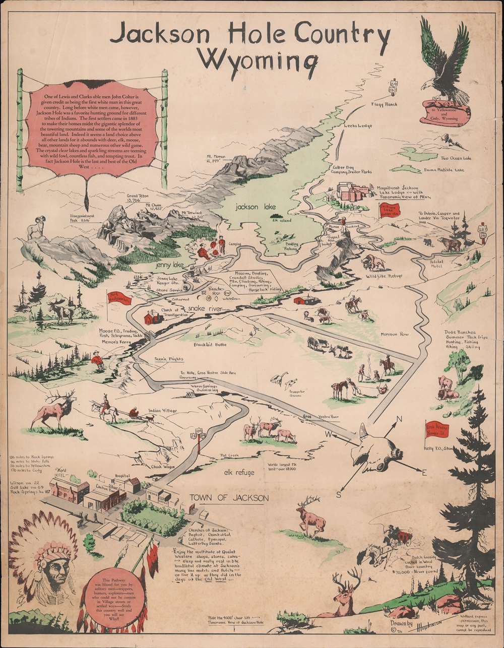

Title
Jackson Hole Country Wyoming.
1956 (dated) 22.25 x 17.25 in (56.515 x 43.815 cm)
1956 (dated) 22.25 x 17.25 in (56.515 x 43.815 cm)
Description
FOR THE ORIGINAL ANTIQUE MAP, WITH HISTORICAL ANALYSIS, CLICK HERE.
Digital Map Information
Geographicus maintains an archive of high-resolution rare map scans. We scan our maps at 300 DPI or higher, with newer images being 600 DPI, (either TIFF or JPEG, depending on when the scan was done) which is most cases in suitable for enlargement and printing.
Delivery
Once you purchase our digital scan service, you will receive a download link via email - usually within seconds. Digital orders are delivered as ZIP files, an industry standard file compression protocol that any computer should be able to unpack. Some of our files are very large, and can take some time to download. Most files are saved into your computer's 'Downloads' folder. All delivery is electronic. No physical product is shipped.
Credit and Scope of Use
You can use your digial image any way you want! Our digital images are unrestricted by copyright and can be used, modified, and published freely. The textual description that accompanies the original antique map is not included in the sale of digital images and remains protected by copyright. That said, we put significant care and effort into scanning and editing these maps, and we’d appreciate a credit when possible. Should you wish to credit us, please use the following credit line:
Courtesy of Geographicus Rare Antique Maps (https://www.geographicus.com).
How Large Can I Print?
In general, at 300 DPI, you should at least be able to double the size of the actual image, more so with our 600 DPI images. So, if the original was 10 x 12 inches, you can print at 20 x 24 inches, without quality loss. If your display requirements can accommodate some loss in image quality, you can make it even larger. That being said, no quality of scan will allow you to blow up at 10 x 12 inch map to wall size without significant quality loss. For more information, it is best consult a printer or reprographics specialist.
Refunds
If the high resolution image you ordered is unavailable, we will fully refund your purchase. Otherwise, digital images scans are a service, not a tangible product, and cannot be returned or refunded once the download link is used.
Cartographer
Harold Isadore Hopkinson (August 8, 1918 - December 18, 2000) was a Mormon artist, illustrator, and art teacher based in Fort Bridger, Wyoming. Hopkinson was born in Salt Lake City, Utah and attended the LDS Business College. He married Vivian Hamblin in 1939, before being drafted into the Navy in 1940 to fight in World War II. After three years of service, he returned to the United States, settling in Laramie to attend college. They eventually settled in Byron, Wyoming, where he acquired a position as an art teacher and school superintendent. In 1988 they relocated to Mesa, Arizona, where they serviced with a mission. Both Harold and his wife died in Mesa. Their son, David Hopkinson, is also a noted artist specializing in Wyoming landscapes. More by this mapmaker...