Digital Image: 1917 Yamazaki Hatsutaro Map of Japanese Immigration to the United States
JapaneseInAmerica-yamazaki-1917_d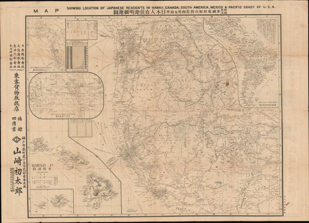

Title
Map Showing Location of Japanese Residents in Hawaii, Canada, South America, Mexico and the Pacific Coast of USA. / 和英両文米国, 布哇, 加奈陀, 墨西哥及南米日本人在住地明細地圖
1917 (dated) 31.5 x 44 in (80.01 x 111.76 cm) 1 : 2820000
1917 (dated) 31.5 x 44 in (80.01 x 111.76 cm) 1 : 2820000
Description
FOR THE ORIGINAL ANTIQUE MAP, WITH HISTORICAL ANALYSIS, CLICK HERE.
Digital Map Information
Geographicus maintains an archive of high-resolution rare map scans. We scan our maps at 300 DPI or higher, with newer images being 600 DPI, (either TIFF or JPEG, depending on when the scan was done) which is most cases in suitable for enlargement and printing.
Delivery
Once you purchase our digital scan service, you will receive a download link via email - usually within seconds. Digital orders are delivered as ZIP files, an industry standard file compression protocol that any computer should be able to unpack. Some of our files are very large, and can take some time to download. Most files are saved into your computer's 'Downloads' folder. All delivery is electronic. No physical product is shipped.
Credit and Scope of Use
You can use your digial image any way you want! Our digital images are unrestricted by copyright and can be used, modified, and published freely. The textual description that accompanies the original antique map is not included in the sale of digital images and remains protected by copyright. That said, we put significant care and effort into scanning and editing these maps, and we’d appreciate a credit when possible. Should you wish to credit us, please use the following credit line:
Courtesy of Geographicus Rare Antique Maps (https://www.geographicus.com).
How Large Can I Print?
In general, at 300 DPI, you should at least be able to double the size of the actual image, more so with our 600 DPI images. So, if the original was 10 x 12 inches, you can print at 20 x 24 inches, without quality loss. If your display requirements can accommodate some loss in image quality, you can make it even larger. That being said, no quality of scan will allow you to blow up at 10 x 12 inch map to wall size without significant quality loss. For more information, it is best consult a printer or reprographics specialist.
Refunds
If the high resolution image you ordered is unavailable, we will fully refund your purchase. Otherwise, digital images scans are a service, not a tangible product, and cannot be returned or refunded once the download link is used.
Cartographer S
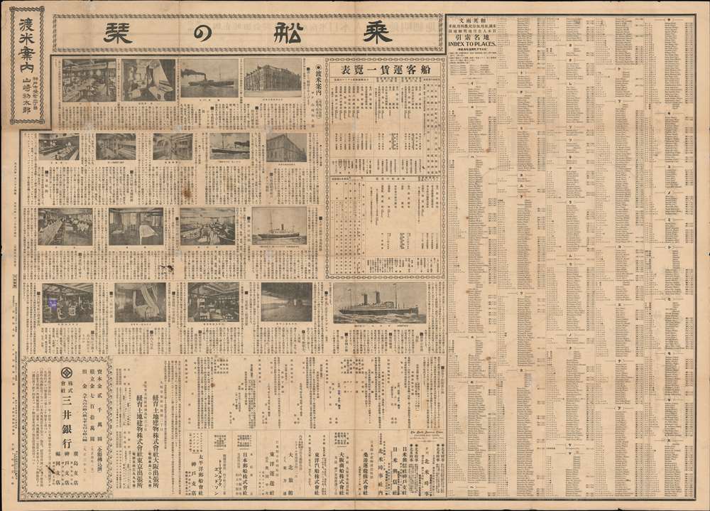
Yamazaki Hatsutaro (山崎初太郎; fl. c. 1898 - 1946) was a Japanese travel and cargo agent based in Kobe, Japan. His, firm, the 'Travel Case Office' focused on shipping between Kobe and North American ports, including Hawaii. He was active from at least 1898 to about 1946, when he declared bankruptcy. He worked with various shipping companies, including Nippon Yusen Kabushiki Kaisha, Osaka Shosen Kaisha, Toyo Kisen Kaisha, and Taiheiyo Yusen Kaisha. Hatsutaro is credited with only one map, a large-scale broadsheet guide for Japanese immigrants to America. More by this mapmaker...
Mitsumura Printing Company (光村印刷株式會社; 1901 - Present) is a Japanese printing and publishing concern founded in 1901 (Meiji 34) by Rika Mitsumura (光村利藻は; 1877 - 1955). Rika was the son of Yabei Mitsumura (光村弥兵衛; 1827 - 1891), a pioneer of Japanese printing. The firm, founded in Kobe, was original the Kansai Photoplate Printing Joint Stock Company. The firm took on the name Mitsumura in 1906 (Meiji 39). They survived the trials of World War II (1939 - 1945) and are now a major printing and publishing concern. Learn More...
References
National Diet Library YG913-2638.