This item has been sold, but you can get on the Waitlist to be notified if another example becomes available, or purchase a digital scan.
1917 Yamazaki Hatsutaro Map of Japanese Immigration to the United States
JapaneseInAmerica-yamazaki-1917$1,750.00

Title
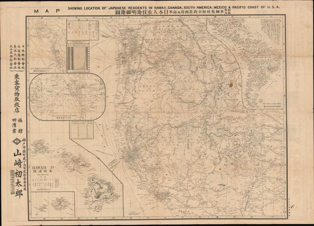
Map Showing Location of Japanese Residents in Hawaii, Canada, South America, Mexico and the Pacific Coast of USA. / 和英両文米国, 布哇, 加奈陀, 墨西哥及南米日本人在住地明細地圖
1917 (dated) 31.5 x 44 in (80.01 x 111.76 cm) 1 : 2820000
1917 (dated) 31.5 x 44 in (80.01 x 111.76 cm) 1 : 2820000
Description
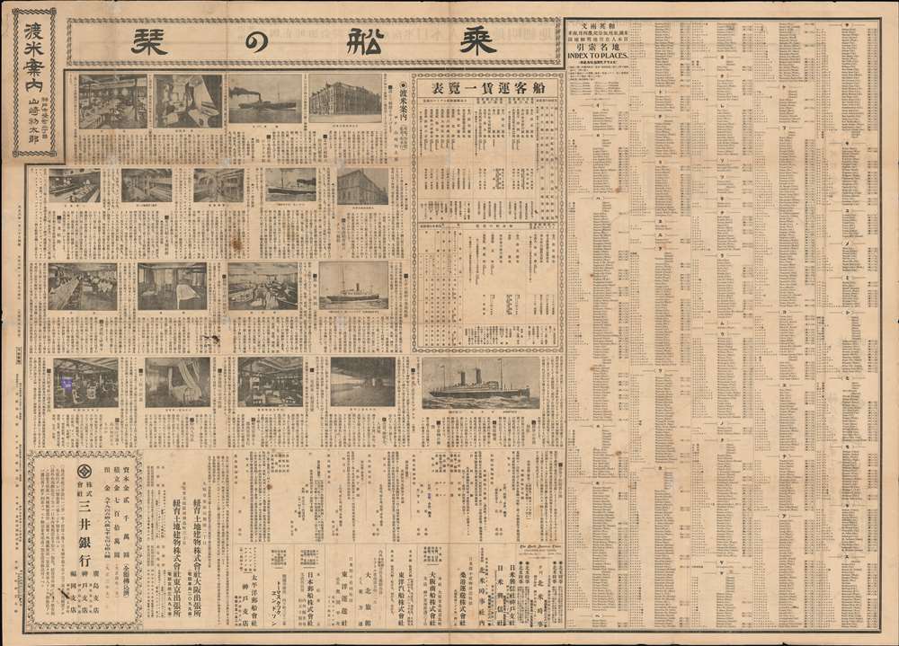
This is a fascinating large scale 1917 Yamazaki Hatsutaro map of the western United States and Hawaii designed act as a guide for Japanese immigrants to the America. The map is centered on California - then the hub of Japanese immigration and cultural life in North America - and extends eastward roughly to Nebraska and Texas. A large inset in the lower left details the Hawaiian Islands, also a center of Japanese immigration. Smaller insets detail global shipping routes, South America, and the Pacific northwest including British Columbia and Alaska. Smaller tables offer statistics on Japanese population density broken down by state, with California having the highest concentration of émigrés. The verso features a comprehensive bi-lingual index and promotional material for Japanese-friendly hotels, steamers, newspapers, and other services.
A Useful Guide
The usefulness of this guide, which would have cost the traveler about 5 cents, is hard to underestimate. One of the most pressing challenges for Japanese émigrés to the Americas was deep language gulf. The present map is fully bi-lingual, allowing the Japanese émigréto know where to go, use the railroad system, and communicate somewhat with English-speaking ticket agents and other citizens.Japanese Immigration to the United States
Japanese immigration to the United States began following Commodore Matthew Perry's Expedition to Japan (1853) and the subsequent opening of that country to foreign trade. The first Japan-San Francisco steamer route began operating in 1855. This roughly coincided with the California Gold Rush (1849 - 1850) and the American Railroad Boom (1840 - 1880). Meanwhile, in Japan a stagnating local economy, high unemployment, and overpopulation led to ever intensifying economic pressure on working class populations. The was only compounded by the Japanese tradition of primogeniture, which encouraged younger sons to leave the family home and seek their own fortunes. Many turned to America. In 1870 there were but 55 Japanese citizens in the US, by 1880, there were 20,00, by 1907, there were 30,000. Immigration continued unablated through the first two decades of the 20th century - with most émigrés settling in enclaves in California and Hawaii. In 1924, hoping to preserve American ethnic homogeneity, Congress passed the Johnson-Reed Act, or Immigration Act of 1924, effectively preventing almost all immigration from Asia until it was revised in 1952.Publication History and Census
This rare broadsheet map was issued in Kobe, Japan, by the shipping agent Yamazaki Hatsutaro (山崎初太郎). There are as many as 9 different editions from roughly 1915 (Taisho 3), the present example being the 4th edition, published in January 20, 1917, or Taisho 6. The map was printed by Mitsumura Printing (光村印刷株式會社) in Kobe. We are aware of editions in black and white, as here, as well as in full printed color. All examples are extremely scarce.CartographerS
Yamazaki Hatsutaro (山崎初太郎; fl. c. 1898 - 1946) was a Japanese travel and cargo agent based in Kobe, Japan. His, firm, the 'Travel Case Office' focused on shipping between Kobe and North American ports, including Hawaii. He was active from at least 1898 to about 1946, when he declared bankruptcy. He worked with various shipping companies, including Nippon Yusen Kabushiki Kaisha, Osaka Shosen Kaisha, Toyo Kisen Kaisha, and Taiheiyo Yusen Kaisha. Hatsutaro is credited with only one map, a large-scale broadsheet guide for Japanese immigrants to America. More by this mapmaker...
Mitsumura Printing Company (光村印刷株式會社; 1901 - Present) is a Japanese printing and publishing concern founded in 1901 (Meiji 34) by Rika Mitsumura (光村利藻は; 1877 - 1955). Rika was the son of Yabei Mitsumura (光村弥兵衛; 1827 - 1891), a pioneer of Japanese printing. The firm, founded in Kobe, was original the Kansai Photoplate Printing Joint Stock Company. The firm took on the name Mitsumura in 1906 (Meiji 39). They survived the trials of World War II (1939 - 1945) and are now a major printing and publishing concern. Learn More...
Condition
Good. A few minor verso repairs and reinforcements at original fold intersections and edges. Old fold lines. Even toning.
References
National Diet Library YG913-2638.