Digital Image: 1890 Meyer Map of Mount Kilimanjaro, Tanzania
KilimanjaroMtn-meyer-1890_d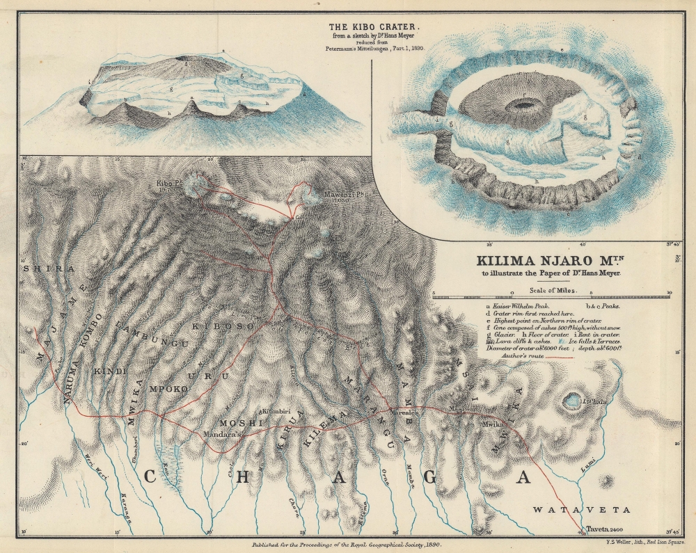

Title
Kilima Njaro Mtn. to illustrate the Paper of Dr. Hans Meyer.
1890 (dated) 8.75 x 10.75 in (22.225 x 27.305 cm) 1 : 253440
1890 (dated) 8.75 x 10.75 in (22.225 x 27.305 cm) 1 : 253440
Description
FOR THE ORIGINAL ANTIQUE MAP, WITH HISTORICAL ANALYSIS, CLICK HERE.
Digital Map Information
Geographicus maintains an archive of high-resolution rare map scans. We scan our maps at 300 DPI or higher, with newer images being 600 DPI, (either TIFF or JPEG, depending on when the scan was done) which is most cases in suitable for enlargement and printing.
Delivery
Once you purchase our digital scan service, you will receive a download link via email - usually within seconds. Digital orders are delivered as ZIP files, an industry standard file compression protocol that any computer should be able to unpack. Some of our files are very large, and can take some time to download. Most files are saved into your computer's 'Downloads' folder. All delivery is electronic. No physical product is shipped.
Credit and Scope of Use
You can use your digial image any way you want! Our digital images are unrestricted by copyright and can be used, modified, and published freely. The textual description that accompanies the original antique map is not included in the sale of digital images and remains protected by copyright. That said, we put significant care and effort into scanning and editing these maps, and we’d appreciate a credit when possible. Should you wish to credit us, please use the following credit line:
Courtesy of Geographicus Rare Antique Maps (https://www.geographicus.com).
How Large Can I Print?
In general, at 300 DPI, you should at least be able to double the size of the actual image, more so with our 600 DPI images. So, if the original was 10 x 12 inches, you can print at 20 x 24 inches, without quality loss. If your display requirements can accommodate some loss in image quality, you can make it even larger. That being said, no quality of scan will allow you to blow up at 10 x 12 inch map to wall size without significant quality loss. For more information, it is best consult a printer or reprographics specialist.
Refunds
If the high resolution image you ordered is unavailable, we will fully refund your purchase. Otherwise, digital images scans are a service, not a tangible product, and cannot be returned or refunded once the download link is used.
Cartographer S
Hans Heinrich Josef Meyer (March 22, 1858 - July 5, 1929) was a German geographer who is credited with being the first European to summit Mount Kilimanjaro. Born in Hildburghausen, Meyer studied history and science in Leipzig, Berlin, and Strasburg, after which he traveled the world, including North America, India, and South Africa. In 1884, he joined his father's (Herrmann Julius Meyer (1826 - 1909)) publishing firm, the Bibliographisches Institut in Leipzig. He became one of the directors the following year. Meyer led three expeditions to Kilimanjaro or the region in 1887, 1888, and 1889 respectively. He made his first summit attempt in 1887, but was forced to turn back at the base of Kibo (one of Kilimanjaro's three summits), discovering he lacked the necessary equipment for deep snow and ice. The following year, 1888, he and Austrian cartographer Oscar Baumann explored the Usambara region with the intention of continuing to Kilimanjaro, but were forced to cut their expedition short due to the s-called Abushiri Revolt. (Both men were captured and held as prisoners and were only released after a large ransom was paid.) Meyer returned to Kilimanjaro in 1889, this time with Ludwig Purtscheller, the celebrated Austrian mountaineer. Meyer and Purtscheller reached the summit of Kibo on October 6, 1889, Purtscheller's 40th birthday. Kibo would not be summitted again until for another twenty years. Meyer became a professor at the University of Leipzig in 1889 and was appointed director of the Institute of Colonial Geography at the University of Leipzig in 1915. Meyer also undertook mountain climbing expeditions in the Canary Islands and Ecuador. More by this mapmaker...
Francis Sidney Weller (April 1849 - 1910) was an English engraver, lithographer, map publisher, and cartographer based in London. He was the son of Edward Weller (July 1, 1819 - 1884) and is named after another important map publisher, Sidney Hall. F. S. Weller took over his father's printing business in 1884. This is the same business that was founded by John Thomson, passed to Sidney Hall, who managed it from 1814 to 1831, then to his widow Selina Price Hall, who ran it to 1853, when it was taken over by his nephew Edward Weller, who rat it until 1884. Weller passed it to his son, Frances Sidney Weller. Learn More...
Royal Geographical Society (fl. 1830 - present) is a British Society established in 1830 to promote geographical science and exploration. Originally titled the "Geographical Society of London", the RGS received its royal charter from Queen Victoria in 1859 shortly after absorbing several similar but more regional societies including the African Association, the Raleigh Club and the Palestine Association. The RGS sponsored many of the most important and exciting voyages of exploration ever undertaken, including the exploration of Charles Darwin, David Livingstone, Robert Falcon Scott, Richard F. Burton, John Speke, George Hayward, H. M Stanley, Ernest Shackleton and Sir Edmond Hillary. Today, the RGS remains a leading global sponsor of geographical and scientific studies. The Society is based in Lowther Lodge, South Kensington, London. Learn More...
Edward Stanford (May 27, 1827 - November 3, 1904) was one of the most prolific map publishing firms of the late 19th century. The company began as a partnership in 1848 between the 21 year old Edward Stanford and the established map dealer Trelawney Saunders. By 1853 the partnership had dissolved and Edward Stanford took full control of the business. A subsequent series of expansions and exciting new map issues finally led to the production of Stanford's masterwork, "Stanford's Library Map of London". This map is still available and remains somewhat accurate. At the time of publishing it was hailed by the Royal Geographical Society as "the most perfect map of London that has ever been issued". In 1882 Edward Stanford Sr. passed the firm on to his son, Edward Stanford Jr. who continued in his father's proud tradition. Today the Stanford firm still publishes maps and remains one of the most important and prolific cartographic publishers in the world. Learn More...
Source
Meyer, H., 'Ascent to the Summit of Kilima-Njaro', Proceedings of the Royal Geographical Society and Monthly Record of Geography Vol. 12, No. 6. (Walker: London) 1890.
References
OCLC 557866045.