1657 Jansson View of Kraków / Krakow, Poland

Krakow-jansson-1657
$4,500.00
Cracovia Metropolis Regni Poloniae. - Main View
Processing...

1657 Jansson View of Kraków / Krakow, Poland

Krakow-jansson-1657

Largest and Best 17th century view of Krakow.
$4,500.00

Title


Cracovia Metropolis Regni Poloniae.
  1657 (undated)     17 x 42 in (43.18 x 106.68 cm)

Description


This is the largest and best 17th-century view of Krakow, Poland. The view was published in c. 1657 by Jan Jansson for his edition of Georg Braun and Franz Hogenberg's Civitatus Orbis Terrarum.
A Closer Look
The view looks on Krakow from the west, overlooking the confluence of the Rudawa and Vistual Rivers, which dominates the right. The image is realistic, drawn from sight, and as such, Krakow's Gothic, Renaissance, and Baroque architectural styles are recognizable.

In the upper sky are six armorial crests, from left: Kleparz (S. Florian), Krakow (three red towers), the Biscione crest of the Sforza (serpent), the White Eagle arms of Poland, Pogoń Litewska (Lithuania: Equestrian Knight), and Kazimierz (K).

In the foreground, a significant historical event unfolds - the procession transferring the Polish King Sigismund III from his castle in Krakow, Wawel, to his country residence at Lobzów. This event took place in 1596, somewhat dating the original art (not lost) on which the view was based.
Publication History and Census
This map was originally engraved c. 1617 under the direction of George Braun for 6th volume of the Civitatus Orbis Terrarum. Early editions are larger by about 1 cm on either side, featuring full borders. When Jan Jannson acquired the Civitatus Orbis Terrarum plates in 1653, he, for an unknown reason, trimmed the plates for this map on both left and right. There is no record of this trimming or why it occurred, but we can infer that the plates may have been damaged due to being overlarge. The present example dates to about 1657.

CartographerS


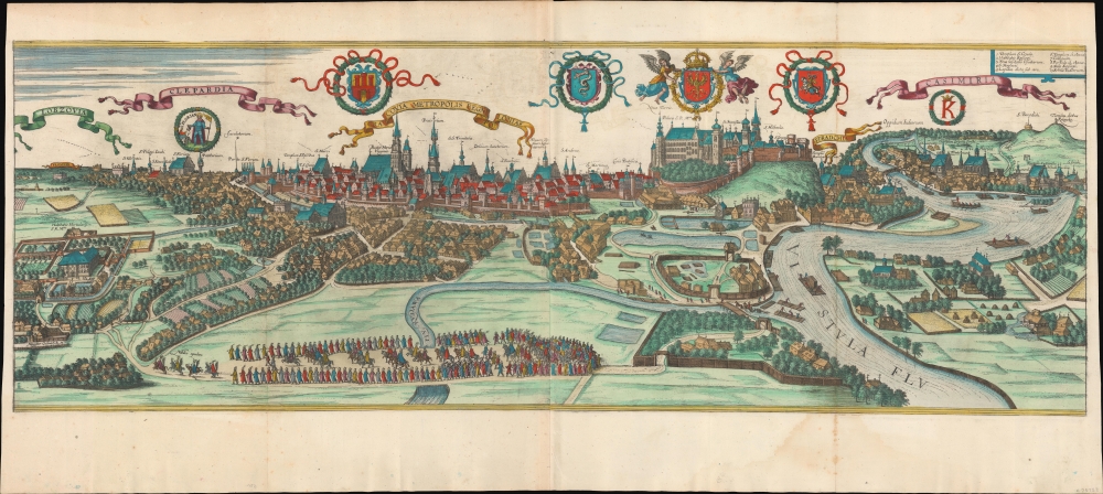
Jan Jansson or Johannes Janssonius (1588 - 1664) was born in Arnhem, Holland. He was the son of a printer and bookseller and in 1612 married into the cartographically prominent Hondius family. Following his marriage he moved to Amsterdam where he worked as a book publisher. It was not until 1616 that Jansson produced his first maps, most of which were heavily influenced by Blaeu. In the mid 1630s Jansson partnered with his brother-in-law, Henricus Hondius, to produce his important work, the eleven volume Atlas Major. About this time, Jansson's name also begins to appear on Hondius reissues of notable Mercator/Hondius atlases. Jansson's last major work was his issue of the 1646 full edition of Jansson's English Country Maps. Following Jansson's death in 1664 the company was taken over by Jansson's brother-in-law Johannes Waesberger. Waesberger adopted the name of Jansonius and published a new Atlas Contractus in two volumes with Jansson's other son-in-law Elizée Weyerstraet with the imprint 'Joannis Janssonii haeredes' in 1666. These maps also refer to the firm of Janssonius-Waesbergius. The name of Moses Pitt, an English map publisher, was added to the Janssonius-Waesbergius imprint for maps printed in England for use in Pitt's English Atlas. More by this mapmaker...


Georg Braun (1541 – March 10, 1622) was a German deacon, viewmaker, and typo-geographer based in Cologne. Along with Franz Hogenberg (1535 - 1590), Braun is best known for his publication of the highly influential city atlas Civitates Orbis Terrarum. The six volume work, with some 546 views, was published between 1572 and 1617 and intended a companion to Abraham Ortelius' Theatrum Orbis Terrarum - thus certain obvious stylistic similarities. In compiling the Civitates Braun took on the role of editor while most of the engraving work was completed by Franz Hogenberg. Braun died, as he was born, in Cologne. Learn More...


Franz Hogenberg (1535 - 1590), often called 'Master Franz,' was a Flemish engraver active in the late 16th century. Hogenberg was born in Mechelen, the son of Nicolas Hogenberg, where he trained under the cartographer H. Terbruggen. He later relocated to Antwerp where he achieved success as an engraver, working with Abraham Ortelius, Hieronymus Cock, and others. In 1568, his name appeared on the list of those banned from the Netherlands by the Duke of Alva, forcing his family to flee to London. There he engraved for Christopher Saxon's Atlas of England and Wales. By 1570 he emigrated to Germany settling in Cologne. In Cologne he married his second wife, Agnes Lomar, with whom he had six children. In 1579 the couple were briefly imprisoned for holding illicit secret religious meetings, but were released in short order. Along with German cleric George Braun (1541 – March 10, 1622), Hogenberg issued the highly influential city atlas Civitates Orbis Terrarum. The six volume work, with some 546 views, was published between 1572 and 1617 and intended a companion to Abraham Ortelius' Thatrum Orbis Terrarum - thus certain obvious stylistic similarities. In compiling the Civitates Hogenberg took on the role of engraver while most of the editing was left to Georg Braun. Hogenberg died in Cologne, Germany, before the Civitates was completed. After his death, Hogenberg's work was continued by his son, Abraham Hogenberg, who, under the direction of Agnes, his mother, took over his father's enterprise at just 20. Learn More...

Source


Jansson, J., Civitatus Orbis Terrarum, (Amsterdam: Jansson) 1657.     The Civitatus Orbis Terrarum is an 6-volume atlas of cities, or town book, compiled and written by George Braun, Canon of Cologne Cathedral and Franz Hogenberg. Braun and Hogenberg gathered together vast amounts of information and draft plans to produce over 500 city views/maps published in six parts between 1572 and 1617. Most of the town views and plans were engraved by Simon van den Neuvel (Novellanus) and Frans Hogenberg, many after drawings by Joris Hoefnagel. The Civitatus Orbis Terrarum was printed in Cologne, but in the Flemish style after Abraham Ortelius, the preeminent cartographer of the period. The text throughout is the work of Braun. The work proved to be a great success, reflecting the period's greater fascination with notable metropolises than with national boundaries. After the initial publication of volume 1, the popularity of the led to a second volume. In the introduction to volume 2, Braun requests that those who live in cities not represented, sent details of their own metropolises. This led to the publication of volumes 3, 4, and 5. Volume 6, the last, did not appear until 1617 under Franz Hogenberg's son, Abraham Hogenberg. The volumes include
  1. Civitates orbis terrarium, first edition 1572.
  2. De praecipuis, totius universi urbibus, liber secundus, first edition 1575.
  3. Urbium praecipuarum totius mundi, liber tertius, first edition 1581.
  4. Urbium praecipuarum totius mundi, liber quartus, first edition 1588.
  5. Urbium praecipuarum mundi theatrum quintum, first edition 1596.
  6. Theatri praecipuarum totius mundi urbium liber sextus, first edition 1617.
New editions Civitatus Orbis Terrarum continued to be released until roughly 1640. In general, the plates and text remained unchanged until 1653, when Jan Jansson purchased the surviving 500 Civitatus Orbis Terrarum plates, 232 of which were adapted and incorporated in the Jansson editions of that work. Others were updated or fully re-engraved.

Condition


Very good. Two sheets joined at center by publisher. Slight wear on old fold lines.

References


Fauser, Alois, Repertorium älterer Topographie, #6964.