This item has been sold, but you can get on the Waitlist to be notified if another example becomes available.
1928 Showa 3 Hiroshi Yoshida Railroad Map of Kyoto, Japan (4 Maps)
Kyoto4Maps2-yoshida-1928$200.00

Title
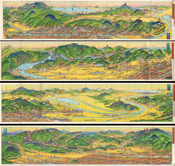
Kyoto Rail Guide.
1928 (dated) 7 x 29 in (17.78 x 73.66 cm)
1928 (dated) 7 x 29 in (17.78 x 73.66 cm)
Description
A rare set of four maps of Kyoto dating to Showa 3 or 1928. Drawn by the famous Japanese illustrator and print maker Hiroshi Yoshida these maps are representative of a style of map that developed in Japan in the early 19th century. Essential transport and rail maps, each of these panoramic views displays a different part of Kyoto - North, South, East and West. Each of the four panels is 7 x 29 inches. All text in Japanese. Color lithograph process. Drawn by Hiroshi Yoshida and published by the Kyoto Education Council.
Cartographer
Yoshida Hatsusaburō (吉田初三郎, March 4, 1884 - August 16, 1955) was a Japanese illustrator and painter of birds-eye views active during the Taisho and Showa periods. Yoshida was born in Kyoto and apprenticed under Takeshiro Kanokgoi (1874 - 1941). Yoshida is significant for pioneering the use parallel perspective birds-eye views to illustrate Japanese bus and railroad transit networks. His first birds-eye view, completed in 1914, illustrated the Keihan railway and was highly praised by no less than Hirohito, then a prince but soon to be the Shōwa Emperor. With the Emperor's approval, Yoshida's views became widely popular and were adopted by the Ministry of Railways for the illustration all of its major public transportation networks. His style was so fashionable and distinctive that an entire genre was named after him (初三郎式絵図), and his works helped to spur a domestic tourism boom in the 1920s – 1930s. Most of his work consisted of city and regional views, though larger views encompassing the entirety of Japan do exist. Yoshida's most significant piece is most likely his rendering of the Hiroshima bombing, which was published in an English language magazine in 1949. He took on Tsunemitsu Kaneko as an assistant and apprentice in the early 1930s. Eventually Kaneko started making parallel perspective views of his own and became Yoshida's primary rival. Although he made over 3,000 maps in his lifetime, Yoshida was known to dedicate months to research and preparation for particular maps. For his 1949 Hiroshima map and his striking depiction of the Great Kanto Earthquake of 1923, he adopted a journalistic approach and spoke to many survivors of the disasters. More by this mapmaker...
Condition
Good condition. Each of the four panels exhibits minor wear on its original fold lines. Original yellow art deco binder is included but worse for wear with half of its cover missing.