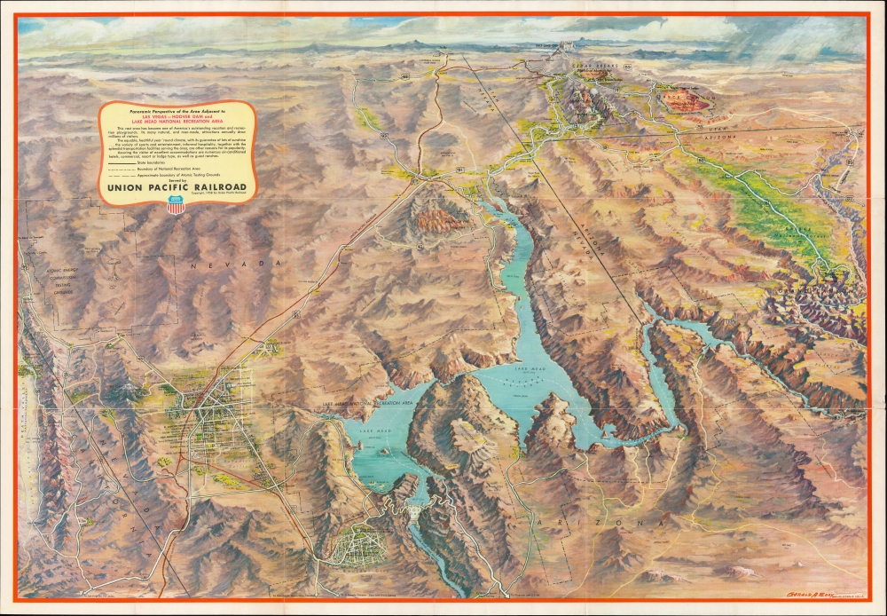
1958 Eddy Bird's-Eye View of Las Vegas, Hoover Dam, Lake Mead, and Environs
LasVegasHooverDam-eddy-1958$350.00


Title
Panoramic Perspective of the Area Adjacent to Las Vegas - Hoover Dam and Lake Mead National Recreation Area.
1958 (dated) 21 x 30.5 in (53.34 x 77.47 cm)
1958 (dated) 21 x 30.5 in (53.34 x 77.47 cm)
Description
A stunning Gerald A. Eddy bird's-eye view map of Hoover Dam, Lake Mead, Las Vegas, and environs, produced in 1958 for the Union Pacific Railroad. It captures the region at the height of the Atomic Age, when Las Vegas became a tourist haven and nearby parts of Nevada became testing grounds for nuclear weapons.
This view was published as a promotional piece for Union Pacific Railroad, and thus a red line traces the railroad's route south from Salt Lake City to Las Vegas and on to Boulder City. The Grand Canyon, Zion National Park, Bryce Canyon National Park, Cedar Breaks National Monument, and, at far left, Death Valley, are highlighted. The region's mountain ranges, canyons, and other natural wonders are also identified.
A Closer Look
Hoover Dam appears in the lower-left next to Boulder City, founded to house the thousands of workers involved in the dam's construction. Lake Mead dominates the foreground, and the view stretches hundreds of miles north to Salt Lake City, Utah. At left in the foreground, Las Vegas is detailed, with casinos, hotels, and the Union Pacific station labeled. This view went through several editions (see 'Publication History and Census' below), with the present edition being notable for the increased detail in Las Vegas and for including a mushroom cloud at Yuca Flats, the Atomic Energy Commission Testing Grounds northwest of Las Vegas.This view was published as a promotional piece for Union Pacific Railroad, and thus a red line traces the railroad's route south from Salt Lake City to Las Vegas and on to Boulder City. The Grand Canyon, Zion National Park, Bryce Canyon National Park, Cedar Breaks National Monument, and, at far left, Death Valley, are highlighted. The region's mountain ranges, canyons, and other natural wonders are also identified.
Hoover Dam
Hoover Dam, built on the Nevada-Arizona border, is a concrete arch-gravity dam in Black Canyon on the Colorado River. It was built between 1931 and 1936, with over 3,000 individuals on the payroll when construction began. The workforce hit its peak in July 1934, with 5,251 people on site. Over one hundred people died during construction. Hoover Dam forms Lake Mead, the largest reservoir in the United States. The dam generates electricity for millions of people in Nevada, Arizona, and California, and, when water levels are sufficient, Lake Mead provides for a wide range of maritime recreation activities.Publication History and Census
This map was drawn by Gerald A. Eddy and published by the Union Pacific Railroad in 1958. Multiple editions of this view were published between 1931 and 1962, with details changed accordingly, such as the name of the Dam (Boulder or Hoover), the development of highways, and the postwar growth of Las Vegas. That being said, the present edition does not appear in the OCLC.Cartographer
Gerald Allen Eddy (October 12, 1889 - September 9, 1967) was an American artist. Born in Michigan, Eddy's parents either divorced or his father died between 1900 and 1910. In 1910 Eddy was living with his mother, brother, and stepfather in Los Angeles and working as an artist. Eddy was a prolific cartographer and created numerous maps of different areas of the western United States. He was married and had a daughter by 1917, according to his World War I draft card. He was married to his wife Madolyn when he died. More by this mapmaker...
Condition
Very good. Light wear along original fold lines. Verso repair to a fold separation. Scuffing to one panel of verso.
References
Rumsey 8608.000 (1961 ed.).