Digital Image: 1836 Gage Large Format Map of Liverpool, England
Liverpool-gage-1836_d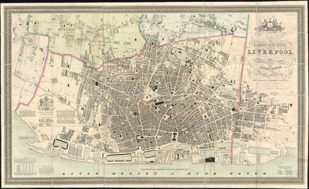

Title
This Trigonometrical Plan of the Town and Port of Liverpool including the environs of Kirkdale Everton Low Hill Edge Hill and Toxteth Park from Actual Survey.
1836 (dated) 41 x 67 in (104.14 x 170.18 cm) 2.298611111
1836 (dated) 41 x 67 in (104.14 x 170.18 cm) 2.298611111
Description
FOR THE ORIGINAL ANTIQUE MAP, WITH HISTORICAL ANALYSIS, CLICK HERE.
Digital Map Information
Geographicus maintains an archive of high-resolution rare map scans. We scan our maps at 300 DPI or higher, with newer images being 600 DPI, (either TIFF or JPEG, depending on when the scan was done) which is most cases in suitable for enlargement and printing.
Delivery
Once you purchase our digital scan service, you will receive a download link via email - usually within seconds. Digital orders are delivered as ZIP files, an industry standard file compression protocol that any computer should be able to unpack. Some of our files are very large, and can take some time to download. Most files are saved into your computer's 'Downloads' folder. All delivery is electronic. No physical product is shipped.
Credit and Scope of Use
You can use your digial image any way you want! Our digital images are unrestricted by copyright and can be used, modified, and published freely. The textual description that accompanies the original antique map is not included in the sale of digital images and remains protected by copyright. That said, we put significant care and effort into scanning and editing these maps, and we’d appreciate a credit when possible. Should you wish to credit us, please use the following credit line:
Courtesy of Geographicus Rare Antique Maps (https://www.geographicus.com).
How Large Can I Print?
In general, at 300 DPI, you should at least be able to double the size of the actual image, more so with our 600 DPI images. So, if the original was 10 x 12 inches, you can print at 20 x 24 inches, without quality loss. If your display requirements can accommodate some loss in image quality, you can make it even larger. That being said, no quality of scan will allow you to blow up at 10 x 12 inch map to wall size without significant quality loss. For more information, it is best consult a printer or reprographics specialist.
Refunds
If the high resolution image you ordered is unavailable, we will fully refund your purchase. Otherwise, digital images scans are a service, not a tangible product, and cannot be returned or refunded once the download link is used.
Cartographer S
Michael Alexander Gage (1788 - 1867) was a Liverpool based civil engineer, surveyor, and malcontent active in the middle part of the 19th century. Gage was born in 1788 in Kings Lynn, Norfolk, England. Seeking greater economic opportunity, he moved to Liverpool in 1811, where he established himself as a tailor and joined the Masonic Grand Lodge, quickly becoming a prominent figure in that society. Gage is best known today for leading a rebellion within the Liverpool Masonic Lodge community. The root of the rebellion was discontent with the dominance of the lodge by noblemen based in London. Gage and his compatriots, who were generally of the working and merchant class, felt disenfranchised and established a rival lodge in Wigan. Although initially successful, Gage soon fell out with the administration of the rebel Wigan Lodge and abandoned Freemasonry altogether, instead launching a new career in civil engineer. In 1835-36, he embarked upon an aggressive plan to resurvey Liverpool, producing in the process, the finest large-format map of Liverpool of the 19th century. Around 1840, having become a prominent Liverpool citizen, Gage began to engage in politics. As a politician and civil engineer Gage vehemently opposed the Rivington Pike plan to increase the city's limited fresh water supply. Gage was elected to the Council of the Confederation, which he used to continue his opposition to the Rivington Pike Waterworks Plan. Ultimately, he resorted to presenting a fraudulent anti-Rivington petition to the council. The fraud was discovered and Gage was committed to London's Newgate prison for a fortnight. By the time her prison term ended, he was deep in debt and by October of 1851, filed for bankruptcy. In 1852 he made a second attempt to establish himself as a surveyor, completing another less well received map of Liverpool docks. Gage died in 1867. He was survived by his son of the same name, also a Civil Engineer. More by this mapmaker...
Thomas Starling (December 24, 1796 - June 15, 1850) was and English line engraver and map publisher based in London during first half of the 19th century. Starling was born in Islington and apprenticed as a stationer in 1811. He was in business for himself as early as 1818, from which time a surviving trade card (Bl 188.v.26) survives at the British Library. By 1824 he was in bankruptcy courts. He recovered somewhat, issuing the small format 1833 Family Cabinet Atlas and engraving Michael Alexander Gage's large format plan of Liverpool. Sterling was elected a Fellow of the Royal Geographical Society in 1833. He died in Essex in 1850. Learn More...
References
OCLC 489942647.