This item has been sold, but you can get on the Waitlist to be notified if another example becomes available, or purchase a digital scan.
1836 Gage Large Format Map of Liverpool, England
Liverpool-gage-1836$1,400.00

Title
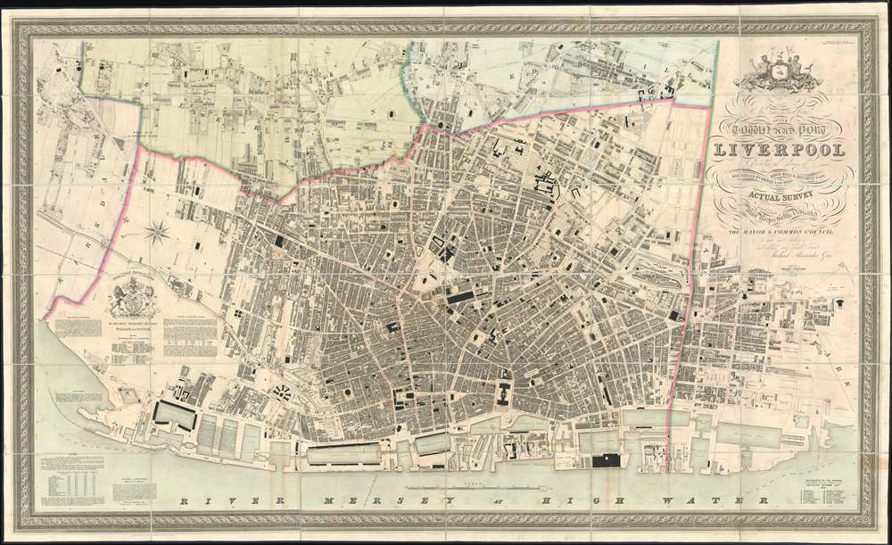
This Trigonometrical Plan of the Town and Port of Liverpool including the environs of Kirkdale Everton Low Hill Edge Hill and Toxteth Park from Actual Survey.
1836 (dated) 41 x 67 in (104.14 x 170.18 cm) 2.298611111
1836 (dated) 41 x 67 in (104.14 x 170.18 cm) 2.298611111
Description
The finest 19th century large format city plan or map of Liverpool, England. Published by Michael Alexander Gage, this first edition map is oriented to the northeast and details the city from Kirkdale to Toxteth Park and eastward as far as Edge Hill. Throughout the plan exhibits extraordinary and meticulous detail, noting every house with its layout, as well as roads, churches, parks, and even individual trees - a testament to Gage's often overshadowed skills as an engraver. In addition, important businesses, including foundries, lumber yards, cooperages, shipbuilders, chrome works, color works, soap makers, breweries, and more are noted - often by their individual company names.
The Liverpool Docks
The 1830s were a period of rapid urban development and expansion for Liverpool and as this map was being issued, the docks were in the process of being expanded. Waterloo Dock, opened 1834 is marked; Victoria and Trafalgar Docks, opened later the year of publication are shown but not yet named.Publication History and Census
This map was engraved in London by Thomas Starling and published on March 1, 1836 by the Liverpool civil engineer Michael Alexander Gage. The map was issued in multiple formats but apparently only a single edition. We have identified 9 institutional holdings, and several examples that have passed through the auction record in the last 10 years. Nonetheless, this map with fine old color is increasingly scarce to the market.CartographerS
Michael Alexander Gage (1788 - 1867) was a Liverpool based civil engineer, surveyor, and malcontent active in the middle part of the 19th century. Gage was born in 1788 in Kings Lynn, Norfolk, England. Seeking greater economic opportunity, he moved to Liverpool in 1811, where he established himself as a tailor and joined the Masonic Grand Lodge, quickly becoming a prominent figure in that society. Gage is best known today for leading a rebellion within the Liverpool Masonic Lodge community. The root of the rebellion was discontent with the dominance of the lodge by noblemen based in London. Gage and his compatriots, who were generally of the working and merchant class, felt disenfranchised and established a rival lodge in Wigan. Although initially successful, Gage soon fell out with the administration of the rebel Wigan Lodge and abandoned Freemasonry altogether, instead launching a new career in civil engineer. In 1835-36, he embarked upon an aggressive plan to resurvey Liverpool, producing in the process, the finest large-format map of Liverpool of the 19th century. Around 1840, having become a prominent Liverpool citizen, Gage began to engage in politics. As a politician and civil engineer Gage vehemently opposed the Rivington Pike plan to increase the city's limited fresh water supply. Gage was elected to the Council of the Confederation, which he used to continue his opposition to the Rivington Pike Waterworks Plan. Ultimately, he resorted to presenting a fraudulent anti-Rivington petition to the council. The fraud was discovered and Gage was committed to London's Newgate prison for a fortnight. By the time her prison term ended, he was deep in debt and by October of 1851, filed for bankruptcy. In 1852 he made a second attempt to establish himself as a surveyor, completing another less well received map of Liverpool docks. Gage died in 1867. He was survived by his son of the same name, also a Civil Engineer. More by this mapmaker...
Thomas Starling (December 24, 1796 - June 15, 1850) was and English line engraver and map publisher based in London during first half of the 19th century. Starling was born in Islington and apprenticed as a stationer in 1811. He was in business for himself as early as 1818, from which time a surviving trade card (Bl 188.v.26) survives at the British Library. By 1824 he was in bankruptcy courts. He recovered somewhat, issuing the small format 1833 Family Cabinet Atlas and engraving Michael Alexander Gage's large format plan of Liverpool. Sterling was elected a Fellow of the Royal Geographical Society in 1833. He died in Essex in 1850. Learn More...
Condition
Very good. Light foxing and toning. Dissected and mounted on original linen. Come with original blue tooled leather book-box.
References
OCLC 489942647.