
This item below is out of stock, but another example (left) is available. To view the available item, click "Details."
Details
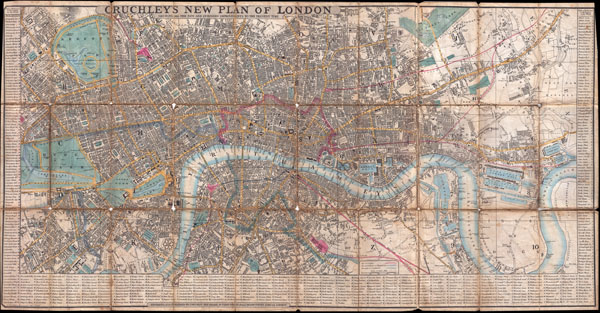
1846 Crutchley Pocket Map of London, England
1846 (dated) $800.00
1849 Cruchley Pocket Map of London, England
London-crutchley-1849$375.00

Title
Cruchley's New Plan of London Shewing all the New and Intended Improvements to the Present Time.
1849 (dated) 17 x 33 in (43.18 x 83.82 cm)
1849 (dated) 17 x 33 in (43.18 x 83.82 cm)
Description
This is a very uncommon and obscure example of Cruchley's New Plan of London. Cruchley's famous plan of London was first issued in 1827 and was updated yearly until this issue, in 1849. The original New Plan of London was much smaller than the current plan covering from Pentonville to Shadwell and from Vauxhall to Brompton. This map is a variant that began to appear around 1829. In addition to the traditional coverage of central London exhibited in the 1827 plan, this map included an eastern extension encompassing the Isle of Dogs and the East India Docks. Though this configuration is much rarer than the more standard variant, there are recorded editions in 1829, 1830, 1833 and 1847. This example, dated June 1st, 1849 is exceptionally rare and does not appear in Hogwego or any of the other standard cartobibliographic references. Most likely, this is the last edition of this map Cruchley published. Like all other editions, this map is surrounded by a detailed street index. Streets, parks, important buildings, districts, and public transport is noted.
Cartographer
George Frederick Cruchley (April 23, 1797 - June 16, 1880) was a London based book and map seller active in the middle part of the 19th century. Cruchley began his cartographic career as an apprentice at the venerable Aaroon Arrowsmith firm. Many of Cruchley's earliest maps bear the words 'From Arrowsmith's' on the imprint. In 1844, Cruchley acquired the massive stock of the important early 19th century firm of John Cary. Cruchley published his own maps as well as reissues of Cary's stock well into the 1870s. He is best known for his detailed plans of London, which in recent years have become increasingly scarce and desirable. Cruchley was based in London on 38 Ludgate Street until 1834 when he moved his offices to 81 Fleet Street. Shortly before his death in 1880 Cruchely auctioned (Hodgson's Auctions, Jan 16, 1877) his entire stock. Many of his map plates were thusly acquired by 'Gall and Inglis' who continued the Cruchley tradition well into the early 20th century. Cruchley's son, also George Frederick (1837 - 1882), continued to work as a book and map seller until his death. More by this mapmaker...
Condition
Good. Dissected and mounted to original linen backing for folding. Exhibits wear and minor loss along original fold lines - especially at fold intersections. Overall toing. Else clean.
References
Howgego, James L., Printed Maps of London circa 1553 - 1850, #307-B.