1846 Crutchley Pocket Map of London, England
London-crutchley-1846$800.00

Title
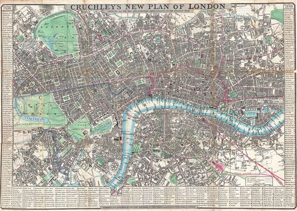
Cruchley's New Plan of London Shewing all the New and Intended Improvements to the Present Time.
1846 (dated) 16.5 x 23.75 in (41.91 x 60.325 cm)
1846 (dated) 16.5 x 23.75 in (41.91 x 60.325 cm)
Description
An extremely attractive 1846 pocket map of central London, England by George Frederick Cruchley. Centered on The Thames River, the map covers from Brompton and Hyde Park eastward as far as the east London Dock, and from Pentonville to southwards to Vauxhall Gardens. All streets, important buildings, railways, bridges (including the ephemeral Hungerforld Suspension Bridge), parks, and docks are noted. The map is surrounded on three sides by a detailed street index.
The early 19th century was a period of extraordinary growth for London as the industrial revolution motivated thousands to relocate to the teaming metropolis. The wealth generated by a global empire combined with a population explosion led to greater demand for a modern urban infrastructure. Cruchley aptly names this his 'New Plan of London' and takes pains to note that it shows all 'new and intended improvements.' From railways and canals, to new bridges, and advances sewage systems, Cruchley's London was transforming into a modern global megapolis. Cruchley first issued this map in 1827, with more than 18 subsequent editions, most of which included significant updates throughout. The present example is the 17th edition.
The early 19th century was a period of extraordinary growth for London as the industrial revolution motivated thousands to relocate to the teaming metropolis. The wealth generated by a global empire combined with a population explosion led to greater demand for a modern urban infrastructure. Cruchley aptly names this his 'New Plan of London' and takes pains to note that it shows all 'new and intended improvements.' From railways and canals, to new bridges, and advances sewage systems, Cruchley's London was transforming into a modern global megapolis. Cruchley first issued this map in 1827, with more than 18 subsequent editions, most of which included significant updates throughout. The present example is the 17th edition.
Cartographer
George Frederick Cruchley (April 23, 1797 - June 16, 1880) was a London based book and map seller active in the middle part of the 19th century. Cruchley began his cartographic career as an apprentice at the venerable Aaroon Arrowsmith firm. Many of Cruchley's earliest maps bear the words 'From Arrowsmith's' on the imprint. In 1844, Cruchley acquired the massive stock of the important early 19th century firm of John Cary. Cruchley published his own maps as well as reissues of Cary's stock well into the 1870s. He is best known for his detailed plans of London, which in recent years have become increasingly scarce and desirable. Cruchley was based in London on 38 Ludgate Street until 1834 when he moved his offices to 81 Fleet Street. Shortly before his death in 1880 Cruchely auctioned (Hodgson's Auctions, Jan 16, 1877) his entire stock. Many of his map plates were thusly acquired by 'Gall and Inglis' who continued the Cruchley tradition well into the early 20th century. Cruchley's son, also George Frederick (1837 - 1882), continued to work as a book and map seller until his death. More by this mapmaker...
Condition
Good. Some wear where originally attached to binder. Discolorations on fold lines. Left and right margins narrow as issued. Backed with archival tissue for stability.
References
Howgego, James L., Printed Maps of London circa 1553-1850, #307.15.