Digital Image: 1823 Percy Map of London, Westminster, and Southwark
London-percy-1823_d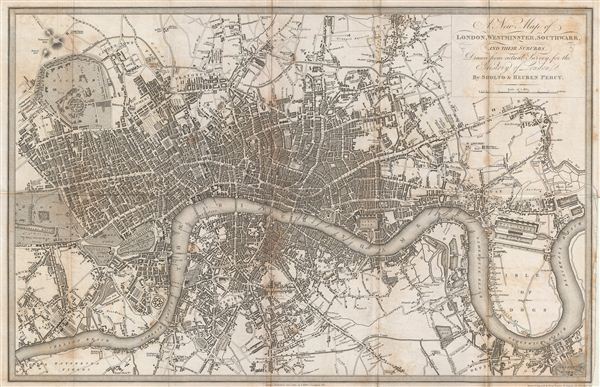

Title
A New Map of London, Westminster, Southwark, and their suburbs.
1823 (dated) 10 x 15.5 in (25.4 x 39.37 cm)
1823 (dated) 10 x 15.5 in (25.4 x 39.37 cm)
Description
FOR THE ORIGINAL ANTIQUE MAP, WITH HISTORICAL ANALYSIS, CLICK HERE.
Digital Map Information
Geographicus maintains an archive of high-resolution rare map scans. We scan our maps at 300 DPI or higher, with newer images being 600 DPI, (either TIFF or JPEG, depending on when the scan was done) which is most cases in suitable for enlargement and printing.
Delivery
Once you purchase our digital scan service, you will receive a download link via email - usually within seconds. Digital orders are delivered as ZIP files, an industry standard file compression protocol that any computer should be able to unpack. Some of our files are very large, and can take some time to download. Most files are saved into your computer's 'Downloads' folder. All delivery is electronic. No physical product is shipped.
Credit and Scope of Use
You can use your digial image any way you want! Our digital images are unrestricted by copyright and can be used, modified, and published freely. The textual description that accompanies the original antique map is not included in the sale of digital images and remains protected by copyright. That said, we put significant care and effort into scanning and editing these maps, and we’d appreciate a credit when possible. Should you wish to credit us, please use the following credit line:
Courtesy of Geographicus Rare Antique Maps (https://www.geographicus.com).
How Large Can I Print?
In general, at 300 DPI, you should at least be able to double the size of the actual image, more so with our 600 DPI images. So, if the original was 10 x 12 inches, you can print at 20 x 24 inches, without quality loss. If your display requirements can accommodate some loss in image quality, you can make it even larger. That being said, no quality of scan will allow you to blow up at 10 x 12 inch map to wall size without significant quality loss. For more information, it is best consult a printer or reprographics specialist.
Refunds
If the high resolution image you ordered is unavailable, we will fully refund your purchase. Otherwise, digital images scans are a service, not a tangible product, and cannot be returned or refunded once the download link is used.
Cartographer S
Ruben and Sholto Percy (1821 - 1828) were London based urban historians active in the early 19th century. The Percys were ostensibly monks of the Benedictine Monastery of Mount Benger, but these identities were in fact pseudonyms for Joseph Clinton Robertson (1788 – September 22, 1852) and Thomas Byerley (1788 - 1824), respectively. The name "Percy" was derived from the Percy Coffee House of Rathbone Place, London, where Byerley and Robertson frequently met to discuss their work. The Percys are best known for their collective works entitled, "The Percy Anecdotes", a multivolume compilation of pirated stories. They also began work on an anecdotal history of Europe's major capitals, though the work, stymied by Byerley's death in 1824, never got beyond London. Joseph Clinton Roberston was a Scotting patent agent, writer, and periodical editor. He was a political radical in the early days of the working-class press in London and in the debates within the Mechanics Institute movement. Thomas Byerley was an English journalist, and became the editor of the Literary Chronicle and assistant editor of The Star>. He was also the editor of The Mirror of Literature, Amusement, and Instruction from 1823 until his death. Byerley also published under the pseudonym Stephen Collet, under which he published Relics of Literature in 1823, which included a long article on graphology which was reprinted in 1875. More by this mapmaker...
Benjamin Rees Davies (1789 - December 16, 1872) was an engraver, cartographer, painter, and map publisher active in the early to mid-19th century. Davies was born in Holborn, England, apprenticed as under John Lodge in 1803. He began publishing around 1811 and is known to have compiled many of own maps from original survey work. From approximately 1848 onward Davies published in conjunction with the Stanford Firm. He is also known to have engraved a number of maps for the Dispatch Atlas and the S.D.U.K. Davies was an early adopter of steel plate engraving and used the exceptional hardness of steel to create some of the most delicately engraved and beautifully produced maps of his era. He was quite famous in England for his detailed street plans of London, which he began publishing in 1848. Davies is known to have worked with numerous other cartographers of his period including French, Mexican, and American map makers. Many of his maps and plans continued to be published and updated posthumously well into the 1880s. Learn More...
Source
Percy, S. and Percy, R., The Percy Histories … of all the capitals of Europe, (London) 1823.
References
Howgego, James L., Printed Maps of London circa 1553-1850, 294-1.