1595 Ortelius Map of Lorraine
Lorraine-ortelius-1595$350.00

Title
Lorraine Lotharingiae Nova Descriptio.
1595 (undated) 14 x 20 in (35.56 x 50.8 cm) 1 : 400000
1595 (undated) 14 x 20 in (35.56 x 50.8 cm) 1 : 400000
Description
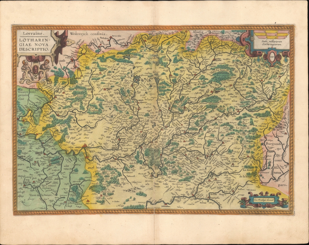
This is a beautiful, original-color example of Abraham Ortelius' 1595 map of the Lorraine region from his Theatrum Orbis Terrarum.
One feature of special interest is the lake (Etang de Lindre) just to the east of Dieuze (Dieuse). The island (actually a peninsula) in the middle of the lake is Tarquimpol (Techemful). Though originally created for irrigation purposes, the lake was stocked with fish for the Dukes of Lorraine. But it became strategically important in later centuries as salt production developed and because it regulated the flow of the Seille (Saône) river.
A Closer Look
Oriented with east at top, the map takes in the Moselle River and other tributaries of the Rhine in what is now northeastern France, with portions of Luxembourg, Alsace, and Burgundy. The Vosges Mountains appear at top-right. The cities of Nancy, near center, and Metz, at center towards bottom-left, were relatively large and important, both culturally and politically, in the late Medieval and early modern period. Aside from towns and cities, which are noted in remarkable detail, waterways and forests (boys) are indicated throughout.The Duchy of Lorraine
The Duchy of Lorraine was created in the 10th century from the territory of Lotharingia, explaining the use of this term in the title. For most of the following 800 years, it formed the western edge of the Holy Roman Empire, and as such was sometimes threatened or briefly occupied by aspiring powers, such as the dukes of Burgundy or the kings of France. It was not fully incorporated into France until the 1760s, though parts of the region seen here, including Metz, were nominally rule by the king of France since the 1550s.One feature of special interest is the lake (Etang de Lindre) just to the east of Dieuze (Dieuse). The island (actually a peninsula) in the middle of the lake is Tarquimpol (Techemful). Though originally created for irrigation purposes, the lake was stocked with fish for the Dukes of Lorraine. But it became strategically important in later centuries as salt production developed and because it regulated the flow of the Seille (Saône) river.
Cartographic Sources
This map is a compilation of 'Lotharingiæ Ducatus Pars Septentrionalis' and 'Lotharingiæ Ducatus Pars Meridionalis' from Mercator's atlas Galliæ tabulæ Geographicæ which appeared in 1585 (Meurer p. 37). Ortelius also mentions in his 'Catalogus Auctorum' a Johan Scillius from Antwerp, who was the designer of a map of Lorraine. Documentary evidence suggests that Ortelius had been looking for a good map of the Lorraine as early as 1575.Publication History and Census
Though dated 1587, this map made its first appearance in the Theatrum in 1590; it would be included in all subsequent editions. This example conforms typographically to the 1595 Latin edition of the Theatrum, of which 500 copies were printed. While the book's first edition was released in 1570, Ortelius continually improved the work - both by adding new maps, and by refining the production of the book. Maps appearing in editions of the Theatrum in the 1580s and 1590s generally display, as here, a finer quality of color than those in the earlier issues of the work. This map is well represented in institutional collections and appears on the market from time to time.CartographerS
Abraham Ortelius (April 14, 1527 - June 28, 1598) also known as Ortels, was a cartographer, geographer, and cosmographer of Brabant, active in Antwerp. He was the creator of the first modern atlas, Theatrum Orbis Terrarum and is a seminal figure in the history of cartography. Along with Gerard Mercator and Gemma Frisius, he was a founder of the Netherlandish school of cartography. His connections with Spain - culminating in his 1575 appointment as Royal Cartographer to King Phillip II of Spain - gave him unmatched access to Spanish geographical knowledge during a crucial period of the Age of Discovery. Ortelius was born in 1527 in Antwerp. In 1547 he entered the Antwerp Guild of Saint Luke as an illuminator of maps. He began trading in books, prints, and maps, traveling regularly to the Frankfurt book and print fair, where in 1554 he met Mercator. He accompanied Mercator on journeys throughout France in 1560 and it was at this time, under Mercator's influence, that he appears to have chosen his career as a scientific geographer. His first published geographic work appeared in 1564, an eight-sheet cordiform world map. A handful of other maps preceded the 1570 publication of the first edition of the Theatrum Orbis Terrarum, which would prove to be his life work. Appearing with but 53 maps in its first edition, Ortelius' work expanded with new maps added regularly. By 1592, it had 134 maps. Many of Ortelius' maps remained the standard for nearly a century. He traveled extensively, but his genius was as a compiler, locating the best informed maps on which to base his own. His contacts throughout Europe and extending even (via the Portuguese) to the Far East were formidable. Moreover, many of his maps were based on his own scholarship, particularly his historical works. His theories of geography were particularly ahead of his time with respect to the notion of continental drift, the possibility of which he mused on as early as 1596, and which would be proven correct centuries later.
In a sense his greatest achievement was his successful navigation of the religious and political violence endemic to his city throughout his adult life: The Dutch Revolt, or Eighty Years' War (1568 - 1648), fully embroiled Antwerp. Although outwardly and officially recognized as Catholic (Arias Montanus vouched for Ortelius' Catholic orthodoxy prior to his appointment as Royal Geographer), Ortelius was able to separate himself from the religious furor which characterized the war in the low countries. Ortelius showed a glimpse of himself in a letter to a friend, regarding humanist Justus Lipsius: 'I do not know whether he is an adherent of the Pope or a Calvinist, but if he has ears to hear, he will neither be one nor the other, for sins are committed on both sides'. Ortelius' own explorations of Biblical history in his maps, and the Christogram contained in his own motto, suggest him to be a religious man, but his abjuration of political religious authorities mark him as an individualist. His tombstone at St Michael's Præmonstratensian Abbey in Antwerp bears the inscription, Quietis cultor sine lite, uxore, prole. ('served quietly, without accusation, wife, and offspring.') More by this mapmaker...
Gerard Mercator (March 5, 1512 - December 2, 1594) is a seminal figure in the history of cartography. Mercator was born near Antwerp as Gerard de Cremere in Rupelmonde. He studied Latin, mathematics, and religion in Rupelmonde before his Uncle, Gisbert, a priest, arranged for him to be sent to Hertogenbosch to study under the Brothers of the Common Life. There he was taught by the celebrated Dutch humanist Georgius Macropedius (Joris van Lanckvelt; April 1487 - July 1558). It was there that he changed him name, adapting the Latin term for 'Merchant', that is 'Mercator'. He went on to study at the University of Louvain. After some time, he left Louvain to travel extensively, but returned in 1534 to study mathematics under Gemma Frisius (1508 - 1555). He produced his first world map in 1538 - notable as being the first to represent North America stretching from the Arctic to the southern polar regions. This impressive work earned him the patronage of the Emperor Charles V, for whom along with Van der Heyden and Gemma Frisius, he constructed a terrestrial globe. He then produced an important 1541 globe - the first to offer rhumb lines. Despite growing fame and imperial patronage, Mercator was accused of heresy and in 1552. His accusations were partially due to his Protestant faith, and partly due to his travels, which aroused suspicion. After being released from prison with the support of the University of Louvain, he resumed his cartographic work. It was during this period that he became a close fried to English polymath John Dee (1527 - 1609), who arrived in Louvain in 1548, and with whom Mercator maintained a lifelong correspondence. In 1552, Mercator set himself up as a cartographer in Duisburg and began work on his revised edition of Ptolemy's Geographia. He also taught mathematics in Duisburg from 1559 to 1562. In 1564, he became the Court Cosmographer to Duke Wilhelm of Cleve. During this period, he began to perfect the novel projection for which he is best remembered. The 'Mercator Projection' was first used in 1569 for a massive world map on 18 sheets. On May 5, 1590 Mercator had a stroke which left him paralyzed on his left side. He slowly recovered but suffered frustration at his inability to continue making maps. By 1592, he recovered enough that he was able to work again but by that time he was losing his vision. He had a second stroke near the end of 1593, after which he briefly lost speech. He recovered some power of speech before a third stroke marked his end. Following Mercator's death his descendants, particularly his youngest son Rumold (1541 - December 31, 1599) completed many of his maps and in 1595, published his Atlas. Nonetheless, lacking their father's drive and genius, the firm but languished under heavy competition from Abraham Ortelius. It was not until Mercator's plates were purchased and republished (Mercator / Hondius) by Henricus Hondius II (1597 - 1651) and Jan Jansson (1588 - 1664) that his position as the preeminent cartographer of the age was re-established. Learn More...
Source
Ortelius, A., Theatrum Orbis Terrarum, (Antwerp: Plantin) 1595.
Abraham Ortelius' magnum opus, Theatrum Orbis Terrarum, was the world's first regularly produced atlas, which 'set the standards for later atlases . . . It was the first undertaking of its kind to reduce the best available maps to an uniform format.' (Koeman) A modestly-sized work of fifty-three maps in its first edition of May 1570, it was an immediate success: there were three further editions that year, and the work remained in print for a total of 32 editions, the last of which was 1641, well after its author's 1598 death. Ortelius added to his atlas constantly, and by 1595 the Theatrum contained 147 maps. Ortelius is renowned generally as an editor, and indeed much of the Theatrum is compiled from a variety of sources: in such cases, Ortelius was scrupulous in naming his sources. But Ortelius was also a mapmaker in his own right: many of his maps are a distillation of various sources into his own work, and there were many maps - particularly in his atlas of Biblical and ancient history Parergon - which were entirely Ortelius' work. In his role as an editor, Ortelius followed in the footsteps of Munster, whose Cosmographia was, until Ortelius, the best window on the world for the curious European reader. In terms of the artistry of his maps, Ortelius oversaw the first great flourishing of copperplate engraving in the service of cartography to occur in Northern Europe. Ortelius' work provided the model for the atlases of Mercator, Hondius, Blaeu and all their progeny in the 17th century - many of whom were to produce faithful editions of Ortelius' maps in their own productions.
Condition
Very good. Generous margins. Superb original color. Mend to bottom centerfold with no loss.
References
Ort 50 (Koeman/Meurer: 122, Karrow: 1/165, van der Krogt AN: 4250:31).