Digital Image: 1836 Schedius / Blaschnek Bilingual Folding Map of the Kingdom of Hungary and Environ
MagyarOrszag-blaschnek-1836_d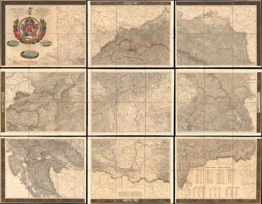


Description
FOR THE ORIGINAL ANTIQUE MAP, WITH HISTORICAL ANALYSIS, CLICK HERE.
Digital Map Information
Geographicus maintains an archive of high-resolution rare map scans. We scan our maps at 300 DPI or higher, with newer images being 600 DPI, (either TIFF or JPEG, depending on when the scan was done) which is most cases in suitable for enlargement and printing.
Delivery
Once you purchase our digital scan service, you will receive a download link via email - usually within seconds. Digital orders are delivered as ZIP files, an industry standard file compression protocol that any computer should be able to unpack. Some of our files are very large, and can take some time to download. Most files are saved into your computer's 'Downloads' folder. All delivery is electronic. No physical product is shipped.
Credit and Scope of Use
You can use your digial image any way you want! Our digital images are unrestricted by copyright and can be used, modified, and published freely. The textual description that accompanies the original antique map is not included in the sale of digital images and remains protected by copyright. That said, we put significant care and effort into scanning and editing these maps, and we’d appreciate a credit when possible. Should you wish to credit us, please use the following credit line:
Courtesy of Geographicus Rare Antique Maps (https://www.geographicus.com).
How Large Can I Print?
In general, at 300 DPI, you should at least be able to double the size of the actual image, more so with our 600 DPI images. So, if the original was 10 x 12 inches, you can print at 20 x 24 inches, without quality loss. If your display requirements can accommodate some loss in image quality, you can make it even larger. That being said, no quality of scan will allow you to blow up at 10 x 12 inch map to wall size without significant quality loss. For more information, it is best consult a printer or reprographics specialist.
Refunds
If the high resolution image you ordered is unavailable, we will fully refund your purchase. Otherwise, digital images scans are a service, not a tangible product, and cannot be returned or refunded once the download link is used.
Cartographer S
Schedius Lajos (December 20, 1768 - November 12, 1847) also known by his German name Johann Ludwig von Schedius, was a prominent Hungarian writer, academic, and philologist. Born in Győr to a German-speaking Evangelical family, he studied at the Bratislava Evangelical Lyceum, the Sopron Gymnasium, and the University of Göttingen, where he studied classics. After completing his studies, despite being only 24 years old and a Protestant (a major disadvantage at the time), Schedius was appointed head of the Department of Philology and Aesthetics at the Royal Hungarian University (commonly known as the University of Pest). He also manages to survive in his position despite being associated with the revolutionary Hungarian Jacobin movement (also known as the Martinovics movement). Both his job posting and his political protection were thanks to the intervention of powerful friends among the Austrian nobility. In any event, Schedius held his position as head of the Department of Philology for 50 years and became a fixture of the intellectual scene in Pest. Despite writing in German and Latin, Schedius supported Hungarian intellectuals, helped publish Hungarian-language works, and championed freedom of the press in the face of the impulse of the Habsburgs to implement strict controls on speech. Schedius also championed some of the most important maps of Hungary of the era, including Lipszky János' 'Mappa Generalis Regni Hungariae…,' which he updated after Lipszky's death, working with Blaschnek Sámuel to produce a map of the kingdom in the late 1830s ('Magyar Ország, Horvát, Tót, Dalmát, és Erdély Országok,' reissued in several editions thereafter). An unpublished updated edition of the map was instrumental to the leaders of the Hungarian Revolution of 1848, which took place after Schedius' death in 1847. More by this mapmaker...
Blaschnék Sámuel (1789 - November 21, 1854), also known as Blaschnek Sámuel Benjámin, was a Pest-based cartographer and surveyor of Silesian origin. His cartographic output primarily consisted of maps of Pest and environs along with a large and influential map of the Kingdom of Hungary prepared with Schedius Lajos, which was an update of the Lipszky János' 'Mappa Generalis Regni Hungariae…' prepared in the early 19th century. Aside from a handful of maps and his death date, little is known of his biographical details or work. Learn More...
Jakob Hyrtl (November 23, 1799 - October 17, 1868), sometimes as Jakub Hyrtl, Jacob Hyrtl, Jacob A. F. Hyrtl, or Jakab Hyrtl, was a Viennese engraver, illustrator, and printmaker. He produced a wide range of works, including maps and book plates, and was especially adept at renderings of buildings and cityscapes. However, Hyrtl is best known for giving to his brother, the anatomist Joseph Hyrtl (1810 - 1894), a skull which Jakob claimed to be the skull of composer Wolfgang Amadus Mozart (1756 - 1791). Joseph examined the skull and then donated it to the City of Salzburg, where Mozart was born and resided for much of his life; it is now held by the Mozarteum (incidentally, much of the rest of Joseph Hyrtl's extensive collection of skulls was donated to the Mütter Museum in Philadelphia). Learn More...
Jakob von Rauschenfels-Steinberg (1779 - August 21, 1841) was an artist, engraver, and lithographer based in Vienna. He was a specialist in depictions of grand buildings, especially churches and cathedrals, and cityscapes. He was among a group of Viennese engravers who contributed to the ten-volume travelogue Das malerische und romantische Deutschland, published between 1837 and 1850, which helped to strengthen German national identity. Learn More...