1836 Schedius / Blaschnek Bilingual Folding Map of the Kingdom of Hungary and Environs
MagyarOrszag-blaschnek-1836$7,500.00


Title
Magyar Ország, Horvát, Tót, Dalmát, és Erdély Országok, a tenger mellék és a végőri videkék kőzonséges pśták és útak főldabrosza... / Vollstaendige General Posten- und Strassen-Karte des Königreichs Ungran, der Königreiche Croatien, Slavonien, Dalmatien, des Grossfürstenth. Siebenbürgen, des Küstenlandes und der Militair-Grenze...
1836 (dated) 72.5 x 93.25 in (184.15 x 236.855 cm) 1 : 470000
1836 (dated) 72.5 x 93.25 in (184.15 x 236.855 cm) 1 : 470000
Description
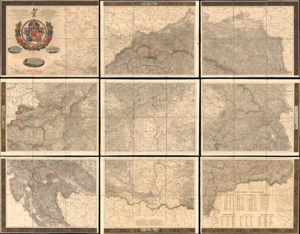
This is Blaschnék Sámuel and Schedius Lajos' lavish, very large-format bilingual (Hungarian-German) c. 1836 folding map of the Kingdom of Hungary, here in its first-edition first-state. It depicts the kingdom in the wake of the Napoleonic Wars, when it was in the midst of a reform movement, and represents the most detailed and up-to-date mapping of the kingdom in the first half of the 19th century.
Coverage includes the entire Kingdom of Hungary, divided into counties (vármegyéi / gespanschaften oder comitate), 'privileged districts,' and military border regions, all of which have their borders shaded and are labeled with Roman numerals and listed in tables at the bottom-right. The Lands of the Hungarian Crown - the Kingdom of Croatia, Kingdom of Slavonia, Kingdom of Dalmatia, and the Grand Principality of Transylvania - which were nominally ruled by the Habsburg monarch as the King of Hungary (rather than Austria or the Holy Roman Empire), are specially designated with distinct border shading. Surrounding areas, including portions of Austria, Congress Poland, the Russian Empire, and the Ottoman Empire, are also depicted in considerable detail. The ország included on individual sheets are also listed at the bottom of each sheet. An detailed trilingual (Hungarian, Latin, German) legend at the bottom-right lists symbols for cities, towns, villages, forts, castles, ecclesiastical territories, historical ruins, battle sites, schools, mines and mineral resources, mountains, waterways, administrative borders, and much more. The map is so large and so detailed that even individual structures such as country houses (einzelnes haus / domus solitaria / egyes ház) and hunting lodges (vadászház / domus venatoria / jägerhaus) are indicated.
Longitude is measured from the Ferro Meridian, and six scales are provided at the bottom. An attractive title cartouche includes the crown of the Hungarian monarchy (the Crown of St. Stephen) and the coats of arms of the constituent parts of the Kingdom of Hungary and the Lands of the Hungarian Crown. Below the title cartouche are three vignettes of Buda, Pest, and Bratislava (Pressburg/Pozsony), while similar vignette illustrations in the border depict bucolic scenes of the people and landscapes of the kingdom.
In any event, by 1836, the misunderstanding over Galicia was cleared up, and publication continued, being completed in 1837 (with the unelaborated map of Galicia). Another issue was printed in 1838 with a slightly different title and some other minor changes. Therefore, there are three states of the first edition of this map if one includes the unpublished 'secret' second sheet. In fact, since the sheets were published individually and could only afterward be combined (typically laid on linen, as here), some surviving examples 'mix and match' sheets from different states of the first edition. (The highly complicated history of the production of the map is covered in expert detail in the 2002 article 'Schedius Lajos és Blaschnék Sámuel Magyarország-térképének kiadásváltozatai' by Pászti László of the National Széchényi Library.)
The calls for reform were impossible to ignore without the danger of provoking even greater unrest, and the monarchy agreed to a degree of diminution of power, with the King convening a Diet every three years. Hungarian was also introduced as an official language alongside Latin, which is likely why it appears here, though Hungarian had been used in some cartographic works since the late 18th century. (By 1850, Hungarian was the kingdom's sole official language.) Still, these reforms were insufficient to quell widespread discontent, which erupted alongside other revolutions throughout Europe in 1848.
In any edition, the map is rare, and the first edition is especially so. Due to the map's complex publication history, dates in catalog listings are often speculative and inconsistent. However, it appears that the first edition (in any state) is only known to be held by the Hungarian National Archives (Magyar Nemzeti Levéltár), while later editions are only noted in the OCLC among the holdings of the University of Illinois at Urbana Champaign, the British Library, and the Bibliothèque nationale de France.
A Closer Look
This gorgeous folding map, divided into nine sheets (individually measuring 24 x 30.75 in.) and mounted on linen, covers more than 6 feet by 7 feet in total when unfolded. In addition to its sheer size, the vignette illustrations, original hand-coloring, intricate borders, and gilt embellishments combine to create a stunning and imposing work.Coverage includes the entire Kingdom of Hungary, divided into counties (vármegyéi / gespanschaften oder comitate), 'privileged districts,' and military border regions, all of which have their borders shaded and are labeled with Roman numerals and listed in tables at the bottom-right. The Lands of the Hungarian Crown - the Kingdom of Croatia, Kingdom of Slavonia, Kingdom of Dalmatia, and the Grand Principality of Transylvania - which were nominally ruled by the Habsburg monarch as the King of Hungary (rather than Austria or the Holy Roman Empire), are specially designated with distinct border shading. Surrounding areas, including portions of Austria, Congress Poland, the Russian Empire, and the Ottoman Empire, are also depicted in considerable detail. The ország included on individual sheets are also listed at the bottom of each sheet. An detailed trilingual (Hungarian, Latin, German) legend at the bottom-right lists symbols for cities, towns, villages, forts, castles, ecclesiastical territories, historical ruins, battle sites, schools, mines and mineral resources, mountains, waterways, administrative borders, and much more. The map is so large and so detailed that even individual structures such as country houses (einzelnes haus / domus solitaria / egyes ház) and hunting lodges (vadászház / domus venatoria / jägerhaus) are indicated.
Longitude is measured from the Ferro Meridian, and six scales are provided at the bottom. An attractive title cartouche includes the crown of the Hungarian monarchy (the Crown of St. Stephen) and the coats of arms of the constituent parts of the Kingdom of Hungary and the Lands of the Hungarian Crown. Below the title cartouche are three vignettes of Buda, Pest, and Bratislava (Pressburg/Pozsony), while similar vignette illustrations in the border depict bucolic scenes of the people and landscapes of the kingdom.
Accidental Subversion
This map is based on Lipszky János' 'Mappa Generalis Regni Hungariae…,' prepared between 1804 and 1806, a groundbreaking work utilizing astronomical positioning (triangulation) whose publication Schedius had supported. After Lipszky died in 1826, Schedius was determined to update it to include new roads and other public works (such as the improved Bega Canal, appearing on Sheet 8), enlisting Blaschnék to assist him, particularly with editing. The individual sheets of the map were meant to be published in stages between 1833 and 1836. However, the second sheet, which covers Galicia (including the Free City of Krakow), was banned by censors. This was ultimately due to Polish nationalist unrest in the region, but more specifically, it was due to the fact that the Schedius and Blaschnék provide relatively little detail on this region compared to areas beyond the borders of Hungary in the rest of the map, inadvertently suggesting that it was not properly part of the Habsburg realm. However, when Schedius and Blaschnék expanded the geography of Galicia to the same level as that of the Hungarian realms, the information was considered too sensitive, and its distribution was banned. Later, this unpublished state of the map was used by the leaders of the Hungarian Revolution of 1848 as it remained the most detailed and up-to-date map of Galicia at the time.In any event, by 1836, the misunderstanding over Galicia was cleared up, and publication continued, being completed in 1837 (with the unelaborated map of Galicia). Another issue was printed in 1838 with a slightly different title and some other minor changes. Therefore, there are three states of the first edition of this map if one includes the unpublished 'secret' second sheet. In fact, since the sheets were published individually and could only afterward be combined (typically laid on linen, as here), some surviving examples 'mix and match' sheets from different states of the first edition. (The highly complicated history of the production of the map is covered in expert detail in the 2002 article 'Schedius Lajos és Blaschnék Sámuel Magyarország-térképének kiadásváltozatai' by Pászti László of the National Széchényi Library.)
Historical Context
This map was produced during the Hungarian Reform Era (1825 - 1848). These reforms were, in large part, a result of the Age of Revolutions and the Napoleonic Wars, which impacted the Habsburg monarchy and awakened social and national movements that would define the following decades. The changes instituted were meant to mollify both Hungarian nationalist sentiment and the discontent of the serfs and other unfree people, who comprised the vast majority of the population. The Absolutist monarch Francis II (r. 1792 - 1835) had led Hungary and the wider Habsburg lands through the trials of the Napoleonic Wars, but at the cost of implementing unpopular, centralizing policies without consulting the nobility, let alone the common people. When Francis finally did convene the Diet in 1825 after a very long hiatus, numerous grievances were aired, and calls for reform were floated. Count István Széchenyi (1791 - 1860) undertook the daring and even scandalous act of delivering a speech in the Diet in Hungarian instead of Latin, advocating for the establishment of a Hungarian Academy of Sciences. Széchenyi also called for a raft of reforms, including the abolition of serfdom, the establishment of a national bank, and major public works, such as the first permanent bridge over the Danube linking Buda and Pest (opened in 1849), which still exists and now bears his name. However, Széchenyi did not propose separation from Austria and, in fact, believed that Hungary's modernization necessitated closer links with Austria. Conversely, a group of lesser nobles led by Lajos Kossuth (1802 - 1894) called for more radical reforms, including parliamentary democracy and de facto independence from Austria. (Kossuth served as Hungary's Governor-President during a brief period of autonomy in 1848 - 1849.)The calls for reform were impossible to ignore without the danger of provoking even greater unrest, and the monarchy agreed to a degree of diminution of power, with the King convening a Diet every three years. Hungarian was also introduced as an official language alongside Latin, which is likely why it appears here, though Hungarian had been used in some cartographic works since the late 18th century. (By 1850, Hungarian was the kingdom's sole official language.) Still, these reforms were insufficient to quell widespread discontent, which erupted alongside other revolutions throughout Europe in 1848.
Publication History and Census
This map was prepared by Schedius Lajos and Blaschnék Sámuel and published between 1833 and 1837. It was engraved by a group of Viennese engravers, Carolus (Karl) Stein, Jakob Rauschenfels von Steinberg, and Jakob Hyrtl, and distributed by 'G. Kilián, the Younger' in Pest. (We have been unable to find any information on Stein or Kilián.) As discussed in the 'Accidental Subversion' section above, the history of the production of the map is highly complex and obscured by censorship, but the present example can be identified as the first state of the first edition of the map by the mention of Kilián, the relatively simple geography of Galicia on the first two sheets, and the inclusion of individual ország at the bottom of each sheet. As discussed above, a second state of the map was censored for years afterward, while a third state was issued in 1838. Later editions of the map were published in 1847, 1861, and 1862.In any edition, the map is rare, and the first edition is especially so. Due to the map's complex publication history, dates in catalog listings are often speculative and inconsistent. However, it appears that the first edition (in any state) is only known to be held by the Hungarian National Archives (Magyar Nemzeti Levéltár), while later editions are only noted in the OCLC among the holdings of the University of Illinois at Urbana Champaign, the British Library, and the Bibliothèque nationale de France.
CartographerS
Schedius Lajos (December 20, 1768 - November 12, 1847) also known by his German name Johann Ludwig von Schedius, was a prominent Hungarian writer, academic, and philologist. Born in Győr to a German-speaking Evangelical family, he studied at the Bratislava Evangelical Lyceum, the Sopron Gymnasium, and the University of Göttingen, where he studied classics. After completing his studies, despite being only 24 years old and a Protestant (a major disadvantage at the time), Schedius was appointed head of the Department of Philology and Aesthetics at the Royal Hungarian University (commonly known as the University of Pest). He also manages to survive in his position despite being associated with the revolutionary Hungarian Jacobin movement (also known as the Martinovics movement). Both his job posting and his political protection were thanks to the intervention of powerful friends among the Austrian nobility. In any event, Schedius held his position as head of the Department of Philology for 50 years and became a fixture of the intellectual scene in Pest. Despite writing in German and Latin, Schedius supported Hungarian intellectuals, helped publish Hungarian-language works, and championed freedom of the press in the face of the impulse of the Habsburgs to implement strict controls on speech. Schedius also championed some of the most important maps of Hungary of the era, including Lipszky János' 'Mappa Generalis Regni Hungariae…,' which he updated after Lipszky's death, working with Blaschnek Sámuel to produce a map of the kingdom in the late 1830s ('Magyar Ország, Horvát, Tót, Dalmát, és Erdély Országok,' reissued in several editions thereafter). An unpublished updated edition of the map was instrumental to the leaders of the Hungarian Revolution of 1848, which took place after Schedius' death in 1847. More by this mapmaker...
Blaschnék Sámuel (1789 - November 21, 1854), also known as Blaschnek Sámuel Benjámin, was a Pest-based cartographer and surveyor of Silesian origin. His cartographic output primarily consisted of maps of Pest and environs along with a large and influential map of the Kingdom of Hungary prepared with Schedius Lajos, which was an update of the Lipszky János' 'Mappa Generalis Regni Hungariae…' prepared in the early 19th century. Aside from a handful of maps and his death date, little is known of his biographical details or work. Learn More...
Jakob Hyrtl (November 23, 1799 - October 17, 1868), sometimes as Jakub Hyrtl, Jacob Hyrtl, Jacob A. F. Hyrtl, or Jakab Hyrtl, was a Viennese engraver, illustrator, and printmaker. He produced a wide range of works, including maps and book plates, and was especially adept at renderings of buildings and cityscapes. However, Hyrtl is best known for giving to his brother, the anatomist Joseph Hyrtl (1810 - 1894), a skull which Jakob claimed to be the skull of composer Wolfgang Amadus Mozart (1756 - 1791). Joseph examined the skull and then donated it to the City of Salzburg, where Mozart was born and resided for much of his life; it is now held by the Mozarteum (incidentally, much of the rest of Joseph Hyrtl's extensive collection of skulls was donated to the Mütter Museum in Philadelphia). Learn More...
Jakob von Rauschenfels-Steinberg (1779 - August 21, 1841) was an artist, engraver, and lithographer based in Vienna. He was a specialist in depictions of grand buildings, especially churches and cathedrals, and cityscapes. He was among a group of Viennese engravers who contributed to the ten-volume travelogue Das malerische und romantische Deutschland, published between 1837 and 1850, which helped to strengthen German national identity. Learn More...
Condition
Very good. Slight transference. Original color and gilt. Mounted on original linen, which is stable.
References
Hungarian National Archives Tárgy No. 17/1-6. Magyarország. Pászti L., 'Schedius Lajos és Blaschnek Sámuel Magyarország-térképének kiadásváltozatai. A szabadságharc hadvezetésének országtérképe,' Geodézia és Kartográfia Nov. 2002, pp. 12–17.