Digital Image: 1725 Van der Aa / Jean Quintin Map of the Maltese Archipelago
Malta-aa-1725_d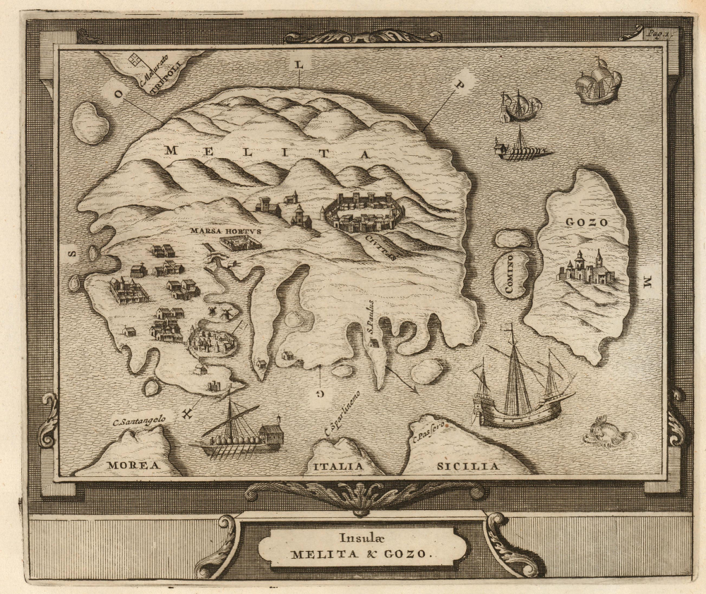


Title
Insulae Melita et Gozo.
1725 (undated) 7 x 8.25 in (17.78 x 20.955 cm)
1725 (undated) 7 x 8.25 in (17.78 x 20.955 cm)
Description
FOR THE ORIGINAL ANTIQUE MAP, WITH HISTORICAL ANALYSIS, CLICK HERE.
Digital Map Information
Geographicus maintains an archive of high-resolution rare map scans. We scan our maps at 300 DPI or higher, with newer images being 600 DPI, (either TIFF or JPEG, depending on when the scan was done) which is most cases in suitable for enlargement and printing.
Delivery
Once you purchase our digital scan service, you will receive a download link via email - usually within seconds. Digital orders are delivered as ZIP files, an industry standard file compression protocol that any computer should be able to unpack. Some of our files are very large, and can take some time to download. Most files are saved into your computer's 'Downloads' folder. All delivery is electronic. No physical product is shipped.
Credit and Scope of Use
You can use your digial image any way you want! Our digital images are unrestricted by copyright and can be used, modified, and published freely. The textual description that accompanies the original antique map is not included in the sale of digital images and remains protected by copyright. That said, we put significant care and effort into scanning and editing these maps, and we’d appreciate a credit when possible. Should you wish to credit us, please use the following credit line:
Courtesy of Geographicus Rare Antique Maps (https://www.geographicus.com).
How Large Can I Print?
In general, at 300 DPI, you should at least be able to double the size of the actual image, more so with our 600 DPI images. So, if the original was 10 x 12 inches, you can print at 20 x 24 inches, without quality loss. If your display requirements can accommodate some loss in image quality, you can make it even larger. That being said, no quality of scan will allow you to blow up at 10 x 12 inch map to wall size without significant quality loss. For more information, it is best consult a printer or reprographics specialist.
Refunds
If the high resolution image you ordered is unavailable, we will fully refund your purchase. Otherwise, digital images scans are a service, not a tangible product, and cannot be returned or refunded once the download link is used.
Cartographer S
Pieter van der Aa (1659 - 1733) was a Dutch publisher of maps and atlases active in the late 17th and early 18th centuries. Van der Aa was born in Leyden in 1659. At nine he was apprenticed to a local bookseller and, by 21, had established his own publishing, printing, and auctioneering house. In 1692 Van der Aa was appointed to be one of the High Commissioners of the Booksellers Guild. During his long and impressive career Van der Aa produced thousands of maps, including a vast 28 volume atlas containing no less than 3,000 maps. Few of Van der Aa's maps were original productions, most being copied from the work of earlier cartographers. Nonetheless, when one of Van der Aa's rare original pieces does appear, his style, with unusual projections, elegant engraving, and precise detail, is instantly recognizable and highly desirable. He also pioneered the cartographic idea of separating border artwork from the map plate itself such that every map in a collection could have a similar elaborate border without actually having to re-engrave the complex plates. This technique was used to great effect by later 18th century publishers like Brion de la Tour. Following Van der Aa's death in 1733, his much admired Nouvel Atlas was reissued by the Dutch firm of Covens & Mortier. Today Van der Aa's work is admired for its fine delicate engraving and unusual projections and is considered highly desirable among collectors. More by this mapmaker...
Jean Quintin or Johannes Quintinus, (Jan 20, 1500 - April 9, 1561) was a French priest, writer, and a knight of the Order of St. John. He is primarily remembered for having produced the earliest description of Malta, including the earliest printed map specifically of the Maltese archipelago. He advanced to some prominence in the Order, becoming secretary to the Grand Master. He wrote broadly; his subjects included geography and cosmography. He wrote his Insulae Melitae Descriptio based on his actual 1530 visit to Malta, combining his eyewitness report with classical and medieval reports, including that which placed Saint Paul's shipwreck there. It is believed that he composed the woodcut map accompanying his description. Although his map was swiftly superseded by those of the Lafreri school, his description was republished several times, and his map would be copied as well. Learn More...
Source
Van der Aa, P., Thesaurus antiquitatum et historiarum nobilissarum insularum, Siciliae, Sardiniae, Corsicae aliarumque adjacentium, Vol 15, (Leiden: van der Aa) 1725.
References
Not in OCLC; see 1355729549 for volume Ganado, A., The Map of Johannes Quintinus Haeduus
and its Derivatives. map 3.