1640 Blaeu Map of the Duchy of Mantua, Lombardy
Mantua-blaeu-1640$450.00

Title
Ducato di Mantova.
1640 (undated) 15 x 19.5 in (38.1 x 49.53 cm) 1 : 270000
1640 (undated) 15 x 19.5 in (38.1 x 49.53 cm) 1 : 270000
Description
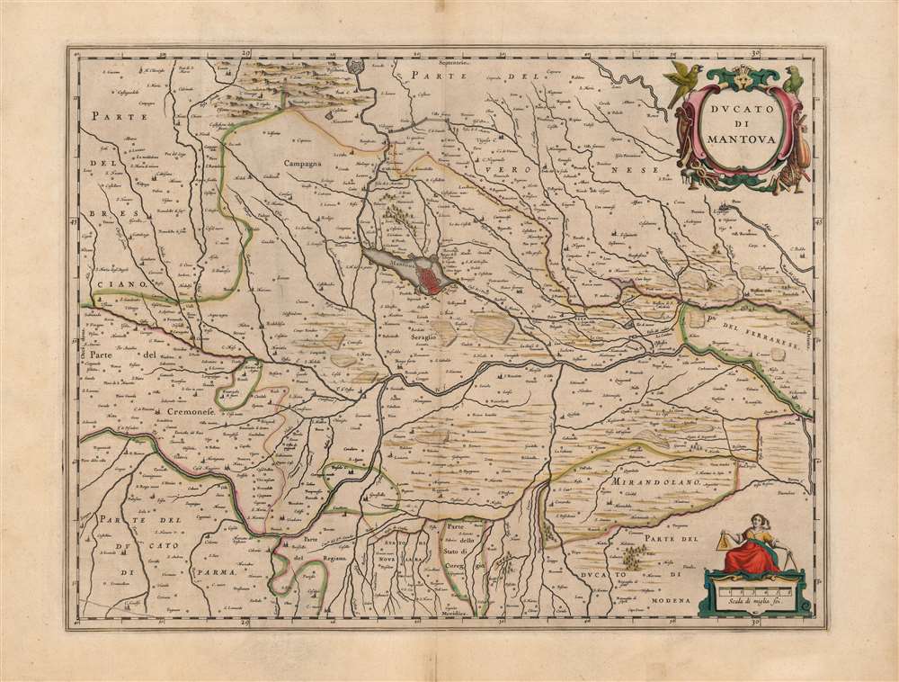
This is a beautiful, original color example of Joan Blaeu's map of the Duchy of Mantua, Lombardy, Italy. It is centered on the city of Mantua, set on its peninsula amidst the array of lakes created by the widening of the Mincio River. The region's network of rivers is evocatively presented. The Po dominates, roughly bisecting the map. Blaeu's work is a more skilled, artistic rendering of the Antonio Magini map of the same title. Magini's map was the first map of the duchy based on modern surveys, and at the time of this map's production remained the state-of-the-art. Its fortresses, towns, farms, and canals are faithfully presented - here, in the sharp, clear engraving that characterizes Blaeu.
The Cartouche
The elegant, strapwork cartouche is framed by musical instruments and astronomical tools. This may be an allusion to the long-standing patronage of the arts and sciences by the Gonzaga family, who ruled the Duchy from the fourteenth century. The cartouche is topped by a pair of parrots - not birds native to Italy. Their presence here may allude to Mantua's trade connections with Venice, which might have brought such exotic creatures to the city. These references, in the 1640s, can only have been flattering or nostalgic. The swarm of writers, artists, musicians, and actors enjoying Gonzaga patronage in the early seventeenth century - including for example Claudio Monteverdi - fled after the last Gonzaga (died 1627). Mantua was subsequently occupied by an Imperial army of 36,000 Landsknecht during the war of succession that followed. Along with the usual horrors of war attending this mercenary army, they also brought plague. By the time this map was printed, the population dropped from 40,000 in 1550 to 14,000.Publication History and Census
This map was engraved by Joan Blaeu for inclusion in the 1640 edition of the Atlas Novus. This example corresponds typographically to both the 1640 and 1644 Latin editions. It is well represented in institutional collections.CartographerS
Joan (Johannes) Blaeu (September 23, 1596 - December 21, 1673) was a Dutch cartographer active in the 17th century. Joan was the son of Willem Janszoon Blaeu, founder of the Blaeu firm. Like his father Willem, Johannes was born in Alkmaar, North Holland. He studied Law, attaining a doctorate, before moving to Amsterdam to join the family mapmaking business. In 1633, Willem arranged for Johannes to take over Hessel Gerritsz's position as the official chartmaker of the Dutch East India Company, although little is known of his work for that organization, which was by contract and oath secretive. What is known is his work supplying the fabulously wealthy VOC with charts was exceedingly profitable. Where other cartographers often fell into financial ruin, the Blaeu firm thrived. It was most likely those profits that allowed the firm to publish the Theatrum Orbis Terrarum, sive, Atlas Novus, their most significant and best-known publication. When Willem Blaeu died in 1638, Johannes, along with his brother Cornelius Blaeu (1616 - 1648) took over the management of the Blaeu firm. In 1662, Joan and Cornelius produced a vastly expanded and updated work, the Atlas Maior, whose handful of editions ranged from 9 to an astonishing 12 volumes. Under the brothers' capable management, the firm continued to prosper until the 1672 Great Amsterdam Fire destroyed their offices and most of their printing plates. Johannes Blaeu, witnessing the destruction of his life's work, died in despondence the following year. He is buried in the Dutch Reformist cemetery of Westerkerk. Johannes Blaeu was survived by his son, also Johannes but commonly called Joan II, who inherited the family's VOC contract, for whom he compiled maps until 1712. More by this mapmaker...
Giovanni Antonio Magini (June 13, 1555 - February 11, 1617) was an Italian astronomer, astrologer, cartographer, and mathematician. Born in Padua, he completed his studies in philosophy in Bologna in 1579. In 1588 he was chosen over Galileo Galilei as the chair of mathematics at the University of Bologna after the death of Egnatio Danti. Magini was a prolific writer, putting forth theories of celestial motion (he was a supporter of a geocentric solar system), the use of quadrants in surveying and astronomy, and trigonometry. In 1608, Magini produced the first map of Italy to improve on that of Gastaldi: his meticulously researched and beautifully engraved 8-sheet Italia Nuova was hugely influential: upon its publication, Blaeu promptly copied it to produce his own wall map of Italy; the rest of the mapmaking establishment swiftly followed suit. Consequently, virtually every 17th century map of Italy can be identified as a derivative of Magini's monumental achievement. His atlas, Atlante geografico d’Italia, was published posthumously by his son in 1620. This work was intended to include maps of every Italian region with exact nomenclature and historical notes. He also served as court astrologer for the Duke of Mantua. Learn More...
Source
Blaeu, J., Atlas Novus, (Amsterdam: Blaeu) 1640-1644.
The classic Dutch atlas, whose publication ushered in the Dutch golden age of cartography. Willem Jansz Blaeu had been, since 1604, producing engraved maps for sale; these were separate issues (and all consequently extremely rare) until the publishing of Blaeu's Appendix in 1630 and 1631, which also included a number of maps purchased from the widow of Jodocus Hondius, (for example his famous iteration of John Smith's map of Virginia.) In 1634, he announced his intention to produce a new world atlas in two volumes, entitled Theatrum Orbis Terrarum, sive Atlas Novus (Théâtre du Monde ou Nouvel Atlas) (in an effort to invoke the successful work of the same title produced by Ortelius the previous century, while reinforcing the notion of it being a new work.) This work was published first in German in 1634, followed by Latin, Dutch and French editions in 1635. Blaeu's maps have always been noted for the quality of their paper, engraving and fine coloring, and this was the intent from the very start. The 1634 announcement of the upcoming work described it: 'All editions on very fine paper, completely renewed with newly engraved copperplates and new, comprehensive descriptions.' (van der Krogt, p,43) Many of the most beautiful and desirable maps available to the modern collector were printed and bound in Blaeu's atlases. Willem's son, Joan, would go on to add further volumes to the Atlas Novus, concurrently printing new editions of the first two volumes with additional maps, in effect making these new editions an entirely new book. Under Joan there would be nine Latin editions, twelve French, at least seven Dutch, and two German. This exceedingly successful work would be the mainstay of the Blaeu firm until 1661, at which point the work was supplanted by Joan Blaeu's masterwork Atlas Maior in 1662.
Condition
Very good. Mends to upper and lower centerfold, not impacting printed image, else excellent. Superb original color.
References
OCLC 931899348. Rumsey 10017.516 (1665).