Digital Image: 1939 Portuguese and Chinese Manuscript Satirical Map of Europe in 1939 (WWII)
MapaHumoristicoDaEuropa-soares-1939_d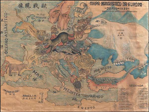

Title
Mapa Humoristico Da Europa - Guerra - 1939 / 歐戰现像
1939 (dated) 18 x 24 in (45.72 x 60.96 cm) 1 : 8190000
1939 (dated) 18 x 24 in (45.72 x 60.96 cm) 1 : 8190000
Description
FOR THE ORIGINAL ANTIQUE MAP, WITH HISTORICAL ANALYSIS, CLICK HERE.
Digital Map Information
Geographicus maintains an archive of high-resolution rare map scans. We scan our maps at 300 DPI or higher, with newer images being 600 DPI, (either TIFF or JPEG, depending on when the scan was done) which is most cases in suitable for enlargement and printing.
Delivery
Once you purchase our digital scan service, you will receive a download link via email - usually within seconds. Digital orders are delivered as ZIP files, an industry standard file compression protocol that any computer should be able to unpack. Some of our files are very large, and can take some time to download. Most files are saved into your computer's 'Downloads' folder. All delivery is electronic. No physical product is shipped.
Credit and Scope of Use
You can use your digial image any way you want! Our digital images are unrestricted by copyright and can be used, modified, and published freely. The textual description that accompanies the original antique map is not included in the sale of digital images and remains protected by copyright. That said, we put significant care and effort into scanning and editing these maps, and we’d appreciate a credit when possible. Should you wish to credit us, please use the following credit line:
Courtesy of Geographicus Rare Antique Maps (https://www.geographicus.com).
How Large Can I Print?
In general, at 300 DPI, you should at least be able to double the size of the actual image, more so with our 600 DPI images. So, if the original was 10 x 12 inches, you can print at 20 x 24 inches, without quality loss. If your display requirements can accommodate some loss in image quality, you can make it even larger. That being said, no quality of scan will allow you to blow up at 10 x 12 inch map to wall size without significant quality loss. For more information, it is best consult a printer or reprographics specialist.
Refunds
If the high resolution image you ordered is unavailable, we will fully refund your purchase. Otherwise, digital images scans are a service, not a tangible product, and cannot be returned or refunded once the download link is used.
Cartographer
António Soares (September, 1894 – July, 1978) was a Portuguese modernist painter, caricaturist, architect, decorator, and set designer active during the early and middle 20th century. Soares was born in Lisbon and had no formal artistic training. He began his career as an illustrator, producing book covers, posters, caricature maps, and announcements, as well as working with magazines such as Ilustração, Magazine Bertrand and ABC. His work is generally modernist and includes caricature with a focus on worldly themes. Later in his career he began to focus on larger painting, murals, and even architectural decoration. Although little known today, he was well respected in his day. He won the Grand Prix at the Paris International Exposition in 1937, received the Columbano Prize twice at the SPN / SNI Modern Art Exhibitions (1935 and 1948), in 1958 was conferred the rank of officer of the Ordem Militar de Sant'Iago da Espada, and in 1962 received the Diário de Notícias Prize. More by this mapmaker...