This item has been sold, but you can get on the Waitlist to be notified if another example becomes available, or purchase a digital scan.
1785 Faden Map of the Mediterranean Region
MediterraneanSea-faden-1785$500.00

Title
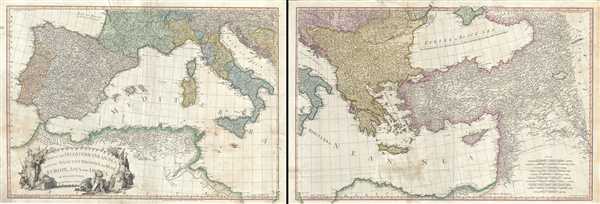
A Map of the Mediterranean Sea with the Adjacent Regions and Seas in Europe, Asia and Africa.
1785 (dated) 25 x 72 in (63.5 x 182.88 cm) 1 : 2850000
1785 (dated) 25 x 72 in (63.5 x 182.88 cm) 1 : 2850000
Description
This is an appealing 1785 map of the Mediterranean region issued by William Faden. A set of two maps, the western sheet covers from Portugal, Spain, Italy, the Maghreb or the Barbary Coast of Africa and includes parts of France and the Balkans. The Spanish Islands of Minorca, Majorca and Ibiza are included, along with Corsica, Sardinia, Malta and Sicily. The eastern sheet extends from Croatia east as far as Iran and from Crimea south to Egypt’s Nile Delta, including the islands of Crete or Candia and Cyprus and the Black Sea. Covers the modern day Greece and Turkey in their entirety (including the area formerly known as Kurdistan), as well as Georgia, Armenia, Jordan, Israel, Palestine, Iran, Iraq, Syria, Ukraine and the Balkan nations. Color coded according to political territory, the map notes several important towns, rivers, cities, lakes, islands and mountains along with other topographic features. Depicts the Italian peninsula divided up in to various states and duchies. Jerusalem, Baghdad (Bagdad), Constantinople (the capital of the Roman Empire) and other important cities.
When this map was drawn this region was dominated by the waning Ottoman hegemony. The Ottomans would nevertheless continue to exert a powerful influence on this region until the early 19th century. The Barbary Coast was a hotbed of piracy – much like the Somali Coast today. The Barbary Pirates would attack trading ships passing through narrow Gibraltar straits and western Mediterranean. Ships would be destroyed or appropriated, cargo seized and the crew and passengers enslaved. By the early 19th century, piracy in this region had become so intense that the United States launched its first major naval offensive against Tripoli. The resultant 1805 Battle of Derne later inspired a portion of the lyrics of the Mariners’ Hymn ‘To the shored of Tripoli’.
This map was printed and issued by William Faden in his 1811 edition of the General Atlas.
Cartographer
William Faden (July 11, 1749 - March 21, 1836) was a Scottish cartographer and map publisher of the late 18th century. Faden was born in London. His father, William MacFaden, was a well-known London printer and publisher of The Literary Magazine. During the Jacobite Rebellion (1745 - 1746), MacFaden changed his family name to Faden, to avoid anti-Scottish sentiment. Faden apprenticed under the engraver James Wigley (1700 - 1782), attaining his freedom in 1771 - in the same year that Thomas Jefferys Sr. died. While Thomas Jefferys Sr. was an important and masterful mapmaker, he was a terrible businessman, and his son, Jefferys Jr., had little interest in building on his father's legacy. MacFaden, perhaps recognizing an opportunity, purchased his son a partnership in the Jefferys firm, which subsequently traded as 'Faden and Jefferys'. Jefferys Jr. also inherited Jefferys Sr.'s title, 'Geographer to the King and to the Prince of Wales'. With little interest in cartography or map publishing, Jefferys Jr. increasingly took a back seat to Faden, and by 1776, he had withdrawn from day-to-day management, although he retained his financial stake. The American Revolutionary War (1775 - 1783) proved to be a boom for the young 'Geographer to the King', who leveraged existing materials and unpublished manuscript maps to which he had access via his official appointment to publish a wealth of important maps, both for official use and the curious public - this period of prosperity laid the financial underpinning for Faden, who by 1783, at the end of the war, acquired full ownership of the firm and removed the Jefferys imprint. In 1801, he engraved and published the first maps for the British Ordnance Survey. By 1822, Faden published over 350 maps, atlases, and military plans. He retired in 1823, selling his plates to James Wyld Sr. Faden died in 1836. More by this mapmaker...
Source
Faden, W., General Atlas, 1811.
Condition
Very good. Minor wear and creasing along original fold lines. Some foxing throughout and minor edge wear. Some verso repairs. Set of two maps.
References
Rumsey 2104.022, 2104.023. Phillips (atlases) 6010, 6013, 6047.