Digital Image: 1742 Doppelmayr Celestial Chart of the Orbits of Mercury and Venus
MercuryVenus-doppelmayr-1742_d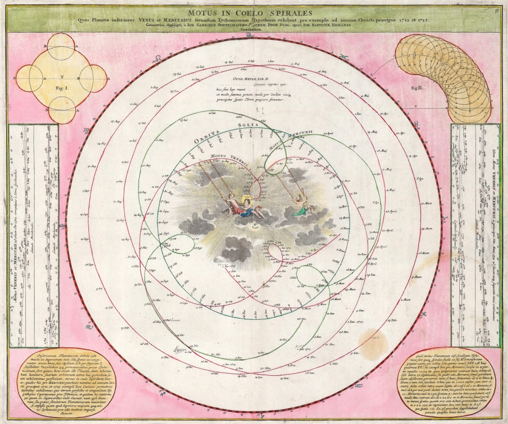

Title
Motus in Coelo Spirales Quos Planetae inferiores Venus et Mercurius secundum Tychonicorum Hypothesin exhibent, pro exemplo ad annum Christi praecipue 1712 et 1713.
1742 (undated) 20 x 23.5 in (50.8 x 59.69 cm)
1742 (undated) 20 x 23.5 in (50.8 x 59.69 cm)
Description
FOR THE ORIGINAL ANTIQUE MAP, WITH HISTORICAL ANALYSIS, CLICK HERE.
Digital Map Information
Geographicus maintains an archive of high-resolution rare map scans. We scan our maps at 300 DPI or higher, with newer images being 600 DPI, (either TIFF or JPEG, depending on when the scan was done) which is most cases in suitable for enlargement and printing.
Delivery
Once you purchase our digital scan service, you will receive a download link via email - usually within seconds. Digital orders are delivered as ZIP files, an industry standard file compression protocol that any computer should be able to unpack. Some of our files are very large, and can take some time to download. Most files are saved into your computer's 'Downloads' folder. All delivery is electronic. No physical product is shipped.
Credit and Scope of Use
You can use your digial image any way you want! Our digital images are unrestricted by copyright and can be used, modified, and published freely. The textual description that accompanies the original antique map is not included in the sale of digital images and remains protected by copyright. That said, we put significant care and effort into scanning and editing these maps, and we’d appreciate a credit when possible. Should you wish to credit us, please use the following credit line:
Courtesy of Geographicus Rare Antique Maps (https://www.geographicus.com).
How Large Can I Print?
In general, at 300 DPI, you should at least be able to double the size of the actual image, more so with our 600 DPI images. So, if the original was 10 x 12 inches, you can print at 20 x 24 inches, without quality loss. If your display requirements can accommodate some loss in image quality, you can make it even larger. That being said, no quality of scan will allow you to blow up at 10 x 12 inch map to wall size without significant quality loss. For more information, it is best consult a printer or reprographics specialist.
Refunds
If the high resolution image you ordered is unavailable, we will fully refund your purchase. Otherwise, digital images scans are a service, not a tangible product, and cannot be returned or refunded once the download link is used.
Cartographer S
Johann Gabriel Doppelmayr (September 27, 1677 - December 1, 1750) was a German mathematician and astronomer active in the first half of the 18th century. Doppelmayr was born in Nuremberg to a merchant family. He attended the Aegidien-Gymnasium and the University of Altdorf where he studied mathematics, physics, and law. His graduating dissertation, a study of the Sun, suggests an early interest in Astronomy. Following his studies in Altdorf, Doppelmayr traveled extensively in Europe and is known to have spent time at the University of Halle, as well as in Utrecht, Leiden, Oxford, and London. He returned to Nuremburg in 1704 to take up a mathematics professorship at his alma mater, the Aegidien-Gymnasium. It may have been here that he developed a relationship with the prominent Nuremburg map publisher J. B. Homann, with whom he prepared a number of important astronomical maps and atlases. The collaboration of over 20 years eventually led to the publication of the Atlas Novus Coelestis in 1742. This astounding work was the most elaborate and detailed astronomical atlas yet published and is today much admired for its rich beautifully engraved plates. Doppelmayr died on 1 December 1750 in Nuremberg, and many later sources claim that his death was caused by the fatal effects of a powerful electrical shock which he had received shortly before while experimenting with a battery of electric capacitors. Other sources, however, suggest that Doppelmayr's electrical experiments were performed several years earlier and were not the cause of his death. Today the Lunar crater Doppelmayr and a minor planetoid are named in his honor. More by this mapmaker...
Homann Heirs (1730 - 1848) were a map publishing house based in Nuremberg, Germany, in the middle to late 18th century. After the great mapmaker Johann Baptist Homann's (1664 - 1724) death, management of the firm passed to his son Johann Christoph Homann (1703 - 1730). J. C. Homann, perhaps realizing that he would not long survive his father, stipulated in his will that the company would be inherited by his two head managers, Johann Georg Ebersberger (1695 - 1760) and Johann Michael Franz (1700 - 1761), and that it would publish only under the name 'Homann Heirs'. This designation, in various forms (Homannsche Heirs, Heritiers de Homann, Lat Homannianos Herod, Homannschen Erben, etc..) appears on maps from about 1731 onwards. The firm continued to publish maps in ever diminishing quantities until the death of its last owner, Christoph Franz Fembo (1781 - 1848). Learn More...
Source
Doppelmayr, Iohannes Gabriel, Atlas Novus Coelestis, (Nuremberg: Homann Heirs) 1742.
References
OCLC 921697698. Rumsey 12499.049 (1716).