1692 Coronelli Map of Mexico
Mexico-coronelli-1692$950.00
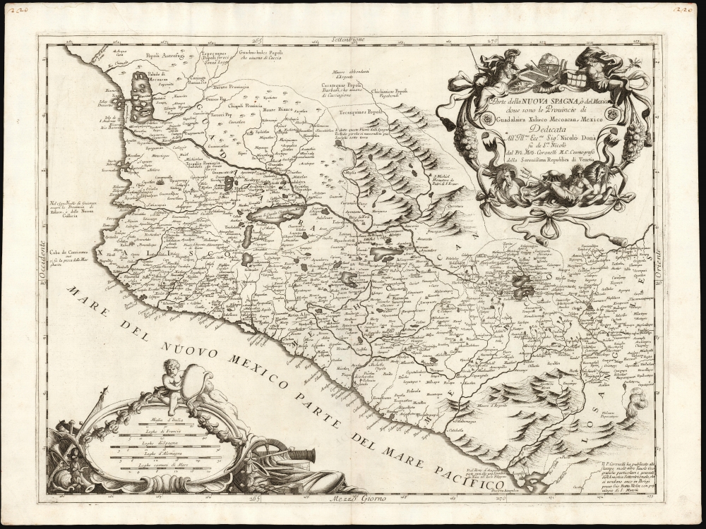

Title
Parte della Nuova Spagna, ò del Mexico dove sono le Provincie di Guadalaira Xalisco Mecoacan e Mexico.
1692 (undated) 17.75 x 23.75 in (45.085 x 60.325 cm) 1 : 2050000
1692 (undated) 17.75 x 23.75 in (45.085 x 60.325 cm) 1 : 2050000
Description
This is a superb example of Vincenzo Coronelli's 1692 map of New Spain. In addition to its presentation of this region at the largest scale found in a 17th century atlas, it represents the first notable improvement on the mapping of this region since the 1579 map of Ortelius, upon which Coronelli's map (and indeed, virtually every map of this region for over a century) was based.
Prominent and mapped with detail are Mexico's two longest rivers, the Lerma (flowing from near Mexico City into Lake Chapala) and the Rio Grande de Santiago, (flowing from Chapala to the Pacific, here named Rio Barania). In particular, the areas around Compostela and Guadalajara are well understood. Further south, the Atoyac River can be recognized. Exhibiting such detail, the map is certainly derived from a first-hand report, albeit far removed.
A Closer Look
The map embraces central and western Mexico, including Mexico City in the southeast, Compostela in the west, and Guadalajara and Michoacan at center. Querétaro and San Miguel de Allende are also marked.It names both indigenous and Spanish settlements on a well-informed array of rivers and lakes. The beautifully executed baroque cartouche and scales are balanced and artful, the latter decorated with instruments of war and surmounted with putti, the former framed with garlands and ribbons, and allegorical depictions of Neptune, Athena, and Mercury. The volcano Popocatépetl is pictured in the lower left. Its placement far to the south amongst other pictorial mountains would have been intended as an illustration as opposed to a literal inclusion of the volcano in that location: the actual position of the mountain west of Puebla and southeast of Mexico City is marked and named properly.Prominent and mapped with detail are Mexico's two longest rivers, the Lerma (flowing from near Mexico City into Lake Chapala) and the Rio Grande de Santiago, (flowing from Chapala to the Pacific, here named Rio Barania). In particular, the areas around Compostela and Guadalajara are well understood. Further south, the Atoyac River can be recognized. Exhibiting such detail, the map is certainly derived from a first-hand report, albeit far removed.
Sources
The core of this map first appeared on Ortelius' 1579 Hispaniae Nova, for which, uncharacteristically, Ortelius did not provide a source. Whether it was derived from a now-lost map by the French cartographer Jean Duran, or Ortelius himself produced it on the descriptions of Juan Lopez de Velasco, the authority of his 16th century map proved unassailable for over a century. Between the first publication of the Ortelius source map and this 1692 Coronelli production, virtually every map of this region would be based on this model, including maps by De Bry, Wytfliet, Quad, Hondius, Blaeu, and Sanson. These are characterized by the hourglass-shaped lake of Mexico City; the largely correct delineations of the River Lerma, Lake Chapala, and the Rio Grande de Santiago; and the distinctive (albeit schematic) lagoon between the mouths of the Chiametla River and the Rio Grande de Santiago. This latter corresponds to the estuary system at the border of Sinaloa and Nayarit, and represents a reasonably accurate representation of what certainly would have been a written description of that agglomeration of lagoons and mangrove swamps.Coronelli's Improvements
While relying faithfully on the granular detail of settlements, place names, and rivers handed down from Ortelius, Coronelli does add improvements not appearing on any intervening iteration of this geography. He replaces the antiquated provincial names of the earlier maps with the more current Guadalajara, Xalisco, Michoaca, Mexico, and Los Angeles. He removes the Spanish military encampments north of Michoacan noted in the Ortelius (which were preserved by Blaeu and Hondius long after the Spanish armies stopped been maneuvering there). Coronelli adds an array of historical notations not included in earlier works. The southeastern extreme of the map is extended here to include the key port of Acapulco, with a note marking its importance Manilla Galleon Trade. It includes an inferred Rio de los Yopes, presenting an encouraging if incorrect water route between Acapulco and Puebla.Publication History and Census
This map was engraved in Coronelli's studio in Venice for inclusion in his 1692Corso geografico universal. It can sometimes be found in his Atlante Veneto. We see perhaps a dozen examples of this map in institutional collections.CartographerS
Vincenzo Maria Coronelli (August 16, 1650 - December 9, 1718) was an important 17th-century cartographer and globe maker based in Venice. Coronelli was born the fifth child of a Venetian tailor. Unlikely to inherit his father's business, he instead apprenticed in Ravenna to a woodcut artist. Around 1663, Coronelli joined the Franciscan Order and, in 1671, entered the Venetian convent of Saint Maria Gloriosa dei Frari. Coronelli excelled in the fields of cosmography, mathematics, and geography. Although his works include the phenomenal Atlante Veneto and Corso Geografico, Coronelli is best known for his globes. In 1678, Coronelli was commissioned to make his first major globes by Ranuccio II Farnese, Duke of Parma. Each superbly engraved globe was five feet in diameter. Louis IV of France, having heard of the magnificent Parma globes, invited Coronelli to Paris, where from 1681-83 he constructed an even more impressive pair of globes measuring over 12 feet in diameter and weighing 2 tons each. The globes earned him the patronage of Louis XIV and privileged access to French cartographic information from Jesuit sources in the New World, particularly Louisiana. Coronelli returned to Venice and continued to publish globes, maps, and atlases, which were admired all over Europe for their beauty, accuracy, and detail. He had a particular fascination for the Great Lakes region, and his early maps of this area were unsurpassed in accuracy for nearly 100 years after their initial publication. He is also well known for his groundbreaking publication of the first accurate map depicting the sources of the Blue Nile. At the height of his career, Coronelli founded the world's first geographical society, the Accademia Cosmografica degli Argonauti, and was awarded the official title Cosmographer of the Republic of Venice. In 1699, in recognition of his extraordinary accomplishment and scholarship, Coronelli was also appointed Father General of the Franciscan Order. The great cartographer and globe maker died in Venice at the age of 68. His extraordinary globes can be seen today at the Bibliothèque Nationale François Mitterrand in Paris, Biblioteca Marciana in Venice, the National Library of Austria, the Globe Museum in Vienna, the Library of Stift Melk, the Special Collections Library of Texas Tech University, as well as lesser works in Trier, Prague, London, and Washington D.C. Coronelli's work is notable for its distinctive style, which is characterized by the high-quality white paper, dark intense impressions, detailed renderings of topographical features in profile, and numerous cartographic innovations. More by this mapmaker...
Abraham Ortelius (April 14, 1527 - June 28, 1598) also known as Ortels, was a cartographer, geographer, and cosmographer of Brabant, active in Antwerp. He was the creator of the first modern atlas, Theatrum Orbis Terrarum and is a seminal figure in the history of cartography. Along with Gerard Mercator and Gemma Frisius, he was a founder of the Netherlandish school of cartography. His connections with Spain - culminating in his 1575 appointment as Royal Cartographer to King Phillip II of Spain - gave him unmatched access to Spanish geographical knowledge during a crucial period of the Age of Discovery. Ortelius was born in 1527 in Antwerp. In 1547 he entered the Antwerp Guild of Saint Luke as an illuminator of maps. He began trading in books, prints, and maps, traveling regularly to the Frankfurt book and print fair, where in 1554 he met Mercator. He accompanied Mercator on journeys throughout France in 1560 and it was at this time, under Mercator's influence, that he appears to have chosen his career as a scientific geographer. His first published geographic work appeared in 1564, an eight-sheet cordiform world map. A handful of other maps preceded the 1570 publication of the first edition of the Theatrum Orbis Terrarum, which would prove to be his life work. Appearing with but 53 maps in its first edition, Ortelius' work expanded with new maps added regularly. By 1592, it had 134 maps. Many of Ortelius' maps remained the standard for nearly a century. He traveled extensively, but his genius was as a compiler, locating the best informed maps on which to base his own. His contacts throughout Europe and extending even (via the Portuguese) to the Far East were formidable. Moreover, many of his maps were based on his own scholarship, particularly his historical works. His theories of geography were particularly ahead of his time with respect to the notion of continental drift, the possibility of which he mused on as early as 1596, and which would be proven correct centuries later.
In a sense his greatest achievement was his successful navigation of the religious and political violence endemic to his city throughout his adult life: The Dutch Revolt, or Eighty Years' War (1568 - 1648), fully embroiled Antwerp. Although outwardly and officially recognized as Catholic (Arias Montanus vouched for Ortelius' Catholic orthodoxy prior to his appointment as Royal Geographer), Ortelius was able to separate himself from the religious furor which characterized the war in the low countries. Ortelius showed a glimpse of himself in a letter to a friend, regarding humanist Justus Lipsius: 'I do not know whether he is an adherent of the Pope or a Calvinist, but if he has ears to hear, he will neither be one nor the other, for sins are committed on both sides'. Ortelius' own explorations of Biblical history in his maps, and the Christogram contained in his own motto, suggest him to be a religious man, but his abjuration of political religious authorities mark him as an individualist. His tombstone at St Michael's Præmonstratensian Abbey in Antwerp bears the inscription, Quietis cultor sine lite, uxore, prole. ('served quietly, without accusation, wife, and offspring.') Learn More...
Source
Coronelli, V., Corso Geografico Universal, (Venice: A spese dell' Autore) 1692.
The Corso Geografico Universale was a Venetian cosmographic atlas issued by the Jesuit Minorite friar, geographer, and globe maker Vincenzo Maria Coronelli. The Corso Geografico is generally dated to 1692 and is considered a follow-up to the Atlante Veneto. There is no confirmed collation of the atlas, as all editions were assembled ad-hoc. Also maps for the atlas were also sold separately, and to subscribers the rate of six cards a month for two years. The maps of the Corso Geografico are generally unique works of great historical value. They are also masterpieces of craftsmanship, engraved between 1688 and 1692 in the well-equipped cartographic workshop of the Saint Maria Gloriosa dei Frari Convent. Editions of the Corso Geografico can roughly be broken up as 68 maps 1689-92; 173 maps, 1692; 260 maps, 1694-97).
Condition
Excellent. Small spot in the cartouche, else fine with a bold strike and generous margins.
References
OCLC 631650419.