1780 Bowles / Lewis Evans Map of the Middle British Colonies
MiddleBritshColonies-bowles-1780$6,500.00

Title
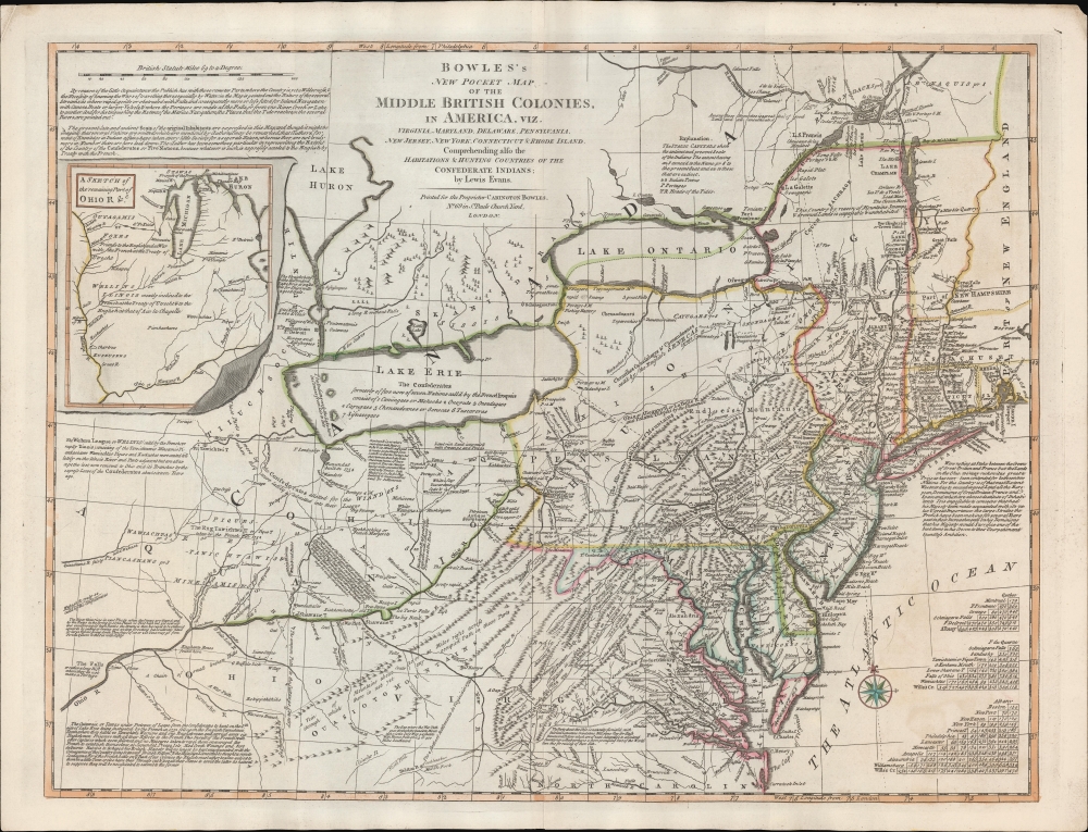
Bowles's New Pocket Map of the Middle British Colonies, in America, Vis. Virginia, Maryland, Delaware, Pensylvaia, New Jersey, New York, Connecticut and RHode Island. Comprending also the Habitations and Hunting Countries of the Confederate Indians: by Lewis Evans.
1780 (undated) 21 x 27 in (53.34 x 68.58 cm) 1 : 2300000
1780 (undated) 21 x 27 in (53.34 x 68.58 cm) 1 : 2300000
Description
A fine example of the 1780 Carington Bowles edition of the Lewis Evans map of the Middle British Colonies - one of the most important maps to emerge out of the French and Indian War (1754 - 1763). Essentially a piracy of a piracy, this is the Carington Bowles 1780 piracy of the 1771 Kitchen/Jefferys piracy of the 1755 Lewis Evans map - here given new relevance in the context of the American Revolutionary War (1775 - 1783). There are numerous subtle changes over earlier editions although the essential Lewis Evans chart - the finest and most comprehensive treatment of the Trans-Appalachia and the Ohio Valley from the French and Indian War through the Revolutionary period - remains the core. Pre-release editions of this map were circulated among British officers, including Major-General Edward Braddock (1695 - 1755), who consulted them during his disastrous 1755 expedition against the French-occupied Ohio River Valley (he was killed in the effort - but not for lack of cartographic reconnaissance).
The Lewis Evans Map
Lewis Evans produced his 1755 map in the context of the French and Indian War. While the Ohio Valley was little traveled and only tenuously understood, it was clear that control of the vast territory was the definitive next step in expansion of colonial power in America. As described by a contemporary, James Maury, in his 1756 Huguenot Family,It is but small, not above half as large as Fry and Jefferson's, consequently crowded. It gives an attentive peruser a clear idea of the value of the now contested lands and waters to either of the two competitor princes, together with a proof, amounting to more than a probability, that of the two who shall remain master of the Ohio and the Lakes must in the course of a few years become sole and absolute lord of North America.Evans himself writes on the map, just southeast of Long Island,
Were nothing at Stake between the Crown of Great Britain and France but the Lands on the Ohio we may recon it as great a Prize as has ever been contended for between two nations. For this Country is of that vast Extent Westwards as to exceed in good Land all the European Dominions of Great Britain, France, and Spain and which are almost destitute of Inhabitants. It is impossible to conceive that had his Majesty been made acquainted with its vales and great Importance the large Stride the French have been making for several years past in their Incroachments on his Dominions that his Majesty would Sacrifice one of the best Gems in his Crown to their Usurpation and boundless Ambition.
Sources
Evans did not personally travel to the Ohio, but he did spend time in the Pennsylvania hinterland and around the Finger Lakes as a surveyor and naturalist, and while working for Thomas Penn on the Pennsylvania-Maryland Border Dispute. In the course of that work, he befriended many travelers who had explored the Trans-Appalachia. For his map, he consulted earlier maps and dredged new data from the accounts of these explorers, military men, trappers, and traders. He relied extensively on the journals of William Franklin for the Ohio, as well as Joshua Fry (c. 1700 - 1754), and fur traders Joseph Dobson, Alexander Maginty, and. Alexander Lowery. He pulls data from William West regarding the course of the Potomac and John Davidson for the Cayúga River. These are just a few of his rich pool of sources.A Closer Look
The resulting map surpassed any that preceded it and was praised by contemporaries over the great John Mitchell map, which appeared in the same year. Although embracing from the Middle Atlantic seaboard and Narragansett Bay nearly as far west as the Mississippi, and from Montreal to the Chesapeake, the map's focus is on the Ohio Valley and the Ontario-Erie corridor. Detail is at once rich and sparce. Data follows the course of the major river systems, with little content away from navigable waterways. He does, however, note the lands of various First Nation peoples - central players in the ongoing war. As both a naturalist and a patriot, Evans also identifies mineral deposits, salt springs, and other data, included to emphasize the resource and travel value of the Ohio Valley. At one point on the lower Ohio, he even identifies the fascinating discovery of 'Elephants Bones', doubtless the fossil remains of an American Mastodon. Evans further adds extensive annotations dealing with geography, indigenous peoples, political issues, and climate.Publication History and Census
This map has a long and complex publication history due in part to Evans' death in 1756, its piracy by multiple publishers, and its ongoing significance covering a period of almost fifty years. Evans first published the map in 1755 (although copies were circulating as early as 1754). That edition was printed in Philadelphia by Benjamin Franklin and D. Hall. It was followed by a series of eighteen subsequent maps (total nineteen), including piracies by Jefferys, Kitchen, Carington Bowles (this example), Bowles and Carver, and reissues of the original Evans map by Thomas Pownall. According to the Sevens analysis (Lewis Evans, his Map), this is state sixteen, the second Bowles issue. While in aggregate the multiple editions of Evans' map are well represented institutionally, specific examples of the 1780 edition are scarce, making it one of the rarer states. We note separate examples of this edition at the Library of Virginia, Yale University, and the Huntington Library. Rarer still on the market.CartographerS
Lewis Evans (1700 - June 11, 1756) was a Welsh born American naturalist, surveyor, and geographer active in Philadelphia and the Ohio Valley in the first half of the 18th century. He was born in Llangwnadl, Carnarvonshire, Wales - a fact which he revealed in his will. Otherwise, little is known of his early life. He had a classical education in England and from his own writings it is hinted that he traveled extensively abroad, as far as India and South America, before settling in Philadelphia. The first mention of Evans is his purchase of Edward Cocker's Arithmetick at Benjamin Franklin's Philadelphia bookshop on November 27, 1736, so he must have immigrated to the colonies sometime before this. From the earliest available records, it is evident he trucked elite intellectual circles, befriending, and even working with Benjamin Franklin, Cadwallader Colden (1688 - 1776), Thomas Pownall (1722 - 1805), Thomas Penn (1702 - 1775), among many others. He lectured throughout Pennsylvania on the wonders of electricity, of which he reportedly had a firm grasp. His cartographic corpus is small but significant. Other than several minor survey maps focusing on holdings in eastern Pennsylvania, Evans's published only two major maps, A Map of Pennsylvania, New Jersey, New York, and the Three Delaware Counties (1752) and A General Map of the Middle British Colonies in America (1755), the latter being a most significant and a landmark production focusing on Trans-Appalachia. It is noteworthy that Evans was a meticulous cartographer and, unlike most mapmakers of this period, based his maps an actual survey work which he personally conducted. Evans died in Philadelphia on June 11, 1756, one year after his greatest work was published. His body lies in the Christ Church Burial Ground in Philadelphia. After his death, his only daughter Amelia was brought up by Deborah and Benjamin Franklin. More by this mapmaker...
The Bowles Family (fl. c. 1714 - 1832) were publishers and map sellers active in London from c. 1714 to c. 1832. The firm, under Thomas Bowles (fl. 1714 - 1763), John Bowles (1701 - 1779), Carrington Bowles (1724 - 1793), and as Bowles and Carver (fl. 1794 - 1832), produced a massive corpus of work that included numerous atlases, pocket maps, and wall maps. The Bowles publishing tradition was kept alive for four generations, starting with Thomas Bowles, a print engraver active in the late 17th century. His son, Thomas Bowles II, produced the firm's first maps at St. Paul's Churchyard, London. Thomas's brother, John Bowles (a.k.a. 'Old John Bowles' or 'Black Horse Bowles'), was also an active publisher established at no. 13 Cornhill. He is credited as one of the first publishers of William Hogarth's works. There, John's son, Carrington Bowles, was introduced to the trade. Carrington took over the Cornhill bookshop and eventually merged it with his uncle's shop in St. Paul's Churchyard. On Carrington's 1793 death, the business was passed to his son Henry Carrington Bowles (1763 - 1830), who partnered with his father's former apprentice Samuel Carver (1756 - 1841), renaming the firm 'Bowles and Carver'. Under this imprint, the firm continued to publish maps and atlases until 1832. Henry Carrington Bowles died in 1830, but Samuel Carver, himself in advanced years and poor health, kept it going for another 2 years before closing the business. Learn More...
Condition
Very good. Original centerfold and pressmark.
References
Huntington Library, 18227. OCLC 793032760.