Digital Image: 1824 Doughty Manuscript Survey of Minetta Street, West Village, New York City
MinettaWestVillage-doughty-1824_d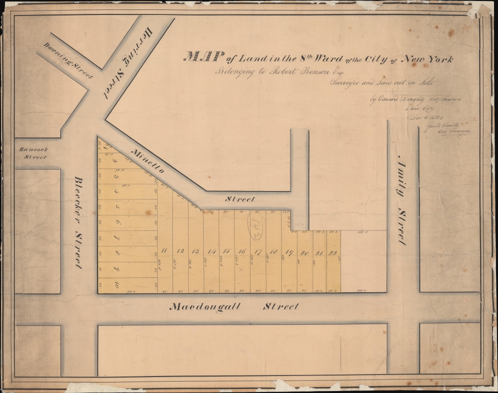

Title
Map of Land in the 8th Ward of the City of New York Belonging to Robert Benson Esqr. Surveyed and Laid out in Lots by Edward Doughty, City Survey a true Copy Dec 6 1824 Geo B Smith City Surveyor.
1824 (dated) 15.75 x 19.75 in (40.005 x 50.165 cm) 1 : 400
1824 (dated) 15.75 x 19.75 in (40.005 x 50.165 cm) 1 : 400
Description
FOR THE ORIGINAL ANTIQUE MAP, WITH HISTORICAL ANALYSIS, CLICK HERE.
Digital Map Information
Geographicus maintains an archive of high-resolution rare map scans. We scan our maps at 300 DPI or higher, with newer images being 600 DPI, (either TIFF or JPEG, depending on when the scan was done) which is most cases in suitable for enlargement and printing.
Delivery
Once you purchase our digital scan service, you will receive a download link via email - usually within seconds. Digital orders are delivered as ZIP files, an industry standard file compression protocol that any computer should be able to unpack. Some of our files are very large, and can take some time to download. Most files are saved into your computer's 'Downloads' folder. All delivery is electronic. No physical product is shipped.
Credit and Scope of Use
You can use your digial image any way you want! Our digital images are unrestricted by copyright and can be used, modified, and published freely. The textual description that accompanies the original antique map is not included in the sale of digital images and remains protected by copyright. That said, we put significant care and effort into scanning and editing these maps, and we’d appreciate a credit when possible. Should you wish to credit us, please use the following credit line:
Courtesy of Geographicus Rare Antique Maps (https://www.geographicus.com).
How Large Can I Print?
In general, at 300 DPI, you should at least be able to double the size of the actual image, more so with our 600 DPI images. So, if the original was 10 x 12 inches, you can print at 20 x 24 inches, without quality loss. If your display requirements can accommodate some loss in image quality, you can make it even larger. That being said, no quality of scan will allow you to blow up at 10 x 12 inch map to wall size without significant quality loss. For more information, it is best consult a printer or reprographics specialist.
Refunds
If the high resolution image you ordered is unavailable, we will fully refund your purchase. Otherwise, digital images scans are a service, not a tangible product, and cannot be returned or refunded once the download link is used.
Cartographer S
Edward Doughty (June 1789 - June 17, 1863) was a New York city surveyor active in the early 19th century. Doughty was born in New York City. He became a prominent New York surveyor during a period when old Manhattan estates were rapidly being broken and lotted according to the 1811 Commissioners Plan - a heady period where surveyors and mapmakers could build impressive fortunes by navigating and understanding the intricate network of heirs and descendants of 18th century grant holders who had legal ownership of much of Manhattan. He appears most active from about 1822 - 1840. He served under George B. Smith as Associate New York City Street Comissioner from 1837 - 1844. He lived for a time at 47 Bowery, but relocated to Newark, New Jersey sometime before 1850. When he was about 70, he state was valued at some 60,000 USD, a considerable some at the time. He trained his son, Samuel Stillwell Doughty (1810 - 1888), as a surveyor as well. More by this mapmaker...
George B. Smith (fl. c. 1825 - 1840) was a prominent New York City surveyor active in the first half of the 20th century. He was appointed Associate New Yorker Street Commissioner under Benjamin Wright in 1827. By 1837 - 1844, he was Street Commissioner, with Edward Doughty (1789 - 1863) working as his assistant. Doughty took over this position in 1844. It is difficult to trace Smith further due to the commonality of his name and lack of records. Learn More...
References
The Evening Post, Jan 8, 1844, Page 4.