This item has been sold, but you can get on the Waitlist to be notified if another example becomes available, or purchase a digital scan.
1824 Doughty Manuscript Survey of Minetta Street, West Village, New York City
MinettaWestVillage-doughty-1824$2,500.00

Title
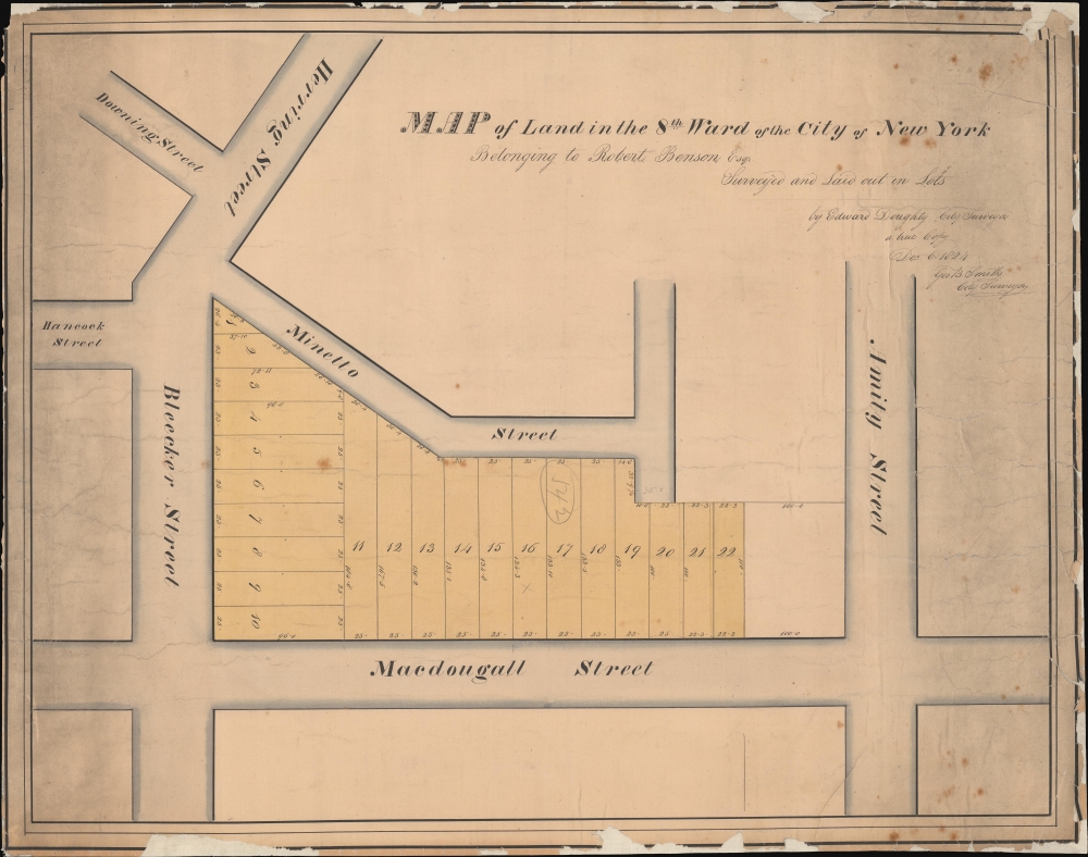
Map of Land in the 8th Ward of the City of New York Belonging to Robert Benson Esqr. Surveyed and Laid out in Lots by Edward Doughty, City Survey a true Copy Dec 6 1824 Geo B Smith City Surveyor.
1824 (dated) 15.75 x 19.75 in (40.005 x 50.165 cm) 1 : 400
1824 (dated) 15.75 x 19.75 in (40.005 x 50.165 cm) 1 : 400
Description
This unique historical artifact is an 1824 manuscript map by Edward Doughty of Minetta Street and Minetta Lane, West Village, New York City. This is the earliest specific map to illustrate these streets, surveyed one year after New York businessman Robert Benson's death, likely to manage the distribution of the estate amongst his heirs. Not without chance, it is one year later in 1825 that the Minettas first appear in New York tax records (from maps to taxes). We further note this survey was used for the seizure and sale of these same lands at public auction by the City of New York in 1844. (The Evening Post, Jan 8, 1844, Page 4.)
Free and 'partially-free' people of color were allowed to settle along the brook, taking land, building farms, and constructing pathways. In the 1810s enterprising builders laid boards over the brook, creating a path called the 'Negro's Causeway', roughly corresponding to Minetta Lane. In 1827, shortly after this map was issued, slavery was abolished in New York and the African American community living in the Minettas grew significantly to the point it was termed 'Little Africa'. In his late 18th century short story Minetta Lane, Stephen Crane described Minetta Lane and Street as 'two of the most enthusiastically murderous thoroughfares in New York.' Writing historically in 1898, Crane describes the streets around when this map was made
A Closer Look
Manuscript. The map is oriented to the northwest. Coverage is bounded by Bleecker, MacDougal, Herring (6th Ave), and Amity (West 3rd), touching tangentially on Hancock and Downing. Property lots between Minetta Street and MacDougal are highlighted - reflecting the lotted estates of New York businessman Robert Benson (see below). Properties are 25-foot-wide through-lots extending between the two streets. Additional properties on Bleecker, also 25 feet wide, extend roughly ninety-six feet into the block.Minetta Street and Minetta Lane
Today both Minetta Street and Minetta Lane have become chic iconic streets, immortalized in literature, film, theater, and New York culinary culture. They are named after a brook that used to flow here - ultimately emptying into the Hudson - named 'Manette' in Algonquin, roughly translating to 'Spirit Water'. The Dutch called it 'Mintje Kil' or 'Little Stream'. The English eventually shortened the name to Minetta.Free and 'partially-free' people of color were allowed to settle along the brook, taking land, building farms, and constructing pathways. In the 1810s enterprising builders laid boards over the brook, creating a path called the 'Negro's Causeway', roughly corresponding to Minetta Lane. In 1827, shortly after this map was issued, slavery was abolished in New York and the African American community living in the Minettas grew significantly to the point it was termed 'Little Africa'. In his late 18th century short story Minetta Lane, Stephen Crane described Minetta Lane and Street as 'two of the most enthusiastically murderous thoroughfares in New York.' Writing historically in 1898, Crane describes the streets around when this map was made
Minetta Lane is a small and becobbled valley between hills and dingy brick. At night the street lamps, burning dimly, cause the shadows to be important, and in the gloom one sees groups of quietly conversant negroes, with occasionally the gleam of a passing growler. Everything is vaguely outlined and of uncertain identity, unless, indeed, it be the flashing buttons and shield of the policeman on his coast. The Sixth Avenue horse-cars jingle past one end of the lane, and a block eastward the little thoroughfare ends in the darkness of M'Dougall Street.The streets became a haunt for New York's underbelly: gangsters, prostitutes, smugglers, and the disenfranchised, including homosexuals, blacks, Asians, Irish, and more. It was also uniquely the home of New York's notorious 'black-and-tan' saloons, the aptly named bars where all races, genders, and persuasions were welcome to mingle. Although derided by 'proper' society, Minetta's black-and-tan saloons represent some of the earliest examples of social tolerance in modern New York, presaging the area's modern-day significance to the Gay Pride and LGBTQ movements.
Property of Robert Benson
The map's title refers to Robert Benson, who died in 1823, likely necessitating the making of this January 1824 survey for the sake of his heirs. Benson was the son of Robert and Catharine (Van Borsum) Benson. His father of the same name was a prominent brewer, and Benson was himself a successful businessman. Before the American Revolutionary War (1775 - 1783), Benson served on the Provincial Congress of New York, and after he became a New York State senator. During the Revolutionary War, he was an aide-de-cape to George Clinton (1739 - 1812), commander of the New York militia and later Vice President. Along with George Washington, Benson entered New York in November 1783, taking control from the British. Benson was New York City clerk from 1784 to 1801. He is also, incidentally, the brother Egbert Benson, the first president of the New-York Historical Society.Publication History and Census
Unpublished manuscript. This map was surveyed and drafted by New York City Surveyor (and later Street Commissioner) Edward Doughty in January of 1824. The present example is a contemporaneous copy made by George B. Smith, another New York City Surveyor who would also later become Street Commissioner. This is the only known surviving example, although it is conceivable that the original January survey survives in the City Clerk's office.CartographerS
Edward Doughty (June 1789 - June 17, 1863) was a New York city surveyor active in the early 19th century. Doughty was born in New York City. He became a prominent New York surveyor during a period when old Manhattan estates were rapidly being broken and lotted according to the 1811 Commissioners Plan - a heady period where surveyors and mapmakers could build impressive fortunes by navigating and understanding the intricate network of heirs and descendants of 18th century grant holders who had legal ownership of much of Manhattan. He appears most active from about 1822 - 1840. He served under George B. Smith as Associate New York City Street Comissioner from 1837 - 1844. He lived for a time at 47 Bowery, but relocated to Newark, New Jersey sometime before 1850. When he was about 70, he state was valued at some 60,000 USD, a considerable some at the time. He trained his son, Samuel Stillwell Doughty (1810 - 1888), as a surveyor as well. More by this mapmaker...
George B. Smith (fl. c. 1825 - 1840) was a prominent New York City surveyor active in the first half of the 20th century. He was appointed Associate New Yorker Street Commissioner under Benjamin Wright in 1827. By 1837 - 1844, he was Street Commissioner, with Edward Doughty (1789 - 1863) working as his assistant. Doughty took over this position in 1844. It is difficult to trace Smith further due to the commonality of his name and lack of records. Learn More...
Condition
Good. Soiling and edge wear; some areas of loss to margin and border. Original backing. Some repairs.
References
The Evening Post, Jan 8, 1844, Page 4.