1676 John Speed County Map of Monmouthshire
Monmouthshire-speed-1676$750.00
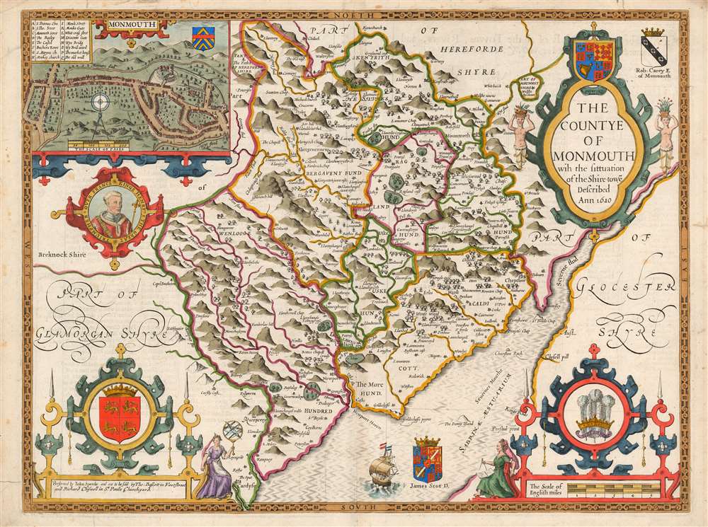

Title
The Countye of Monmouth wih the sittuation of the Shiretowē Described Ann 1610.
1676 (dated) 15 x 20 in (38.1 x 50.8 cm) 1 : 110000
1676 (dated) 15 x 20 in (38.1 x 50.8 cm) 1 : 110000
Description
This is John Speed's map of the county of Monmouthshire, Wales. It was included in Speed's The Theatre of the Empire of Great Britaine. The map is richly detailed, showing towns, abbeys, castles, forests, and parklands. The countryside's rugged terrain is shown pictorially. An inset plan in the upper left details the castle and town of Monmouth. In it, a key labels the important streets, locations of the castle itself, St. Mary's Church, the town market, and the city's old wall and gates. Below the inset is a medallion depicting England's King Henry V (1386 - 1422), who was also known as Henry of Monmouth. King Henry's famed victories in the Hundred Years' War are celebrated in the medallion's text, 'Kinge Henry 5, The Great Triumpher Over France.' Henry's famous victory at Agincourt was nearly two centuries distant at the time this map was engraved: but those remote events had been made current by Shakespeare's 'Henriad' plays, which fixed Henry as the exemplar of the noble English war leader.
Heraldric Notes
The map, as it was originally engraved in 1611, is decorated with the the Royal Arms of England (atop the cartouche) the arms of Gwynedd (in the lower left) and the badge of the Prince of Wales (in the lower right). Two escutcheons were added to the map, probably by Francis Lamb, in preparation for the 1676 Bassett and Chiswell edition of the atlas: these are the arms of Robert Carey, the First Earl of Monmouth (1560-1639), and of James Scott, (1649 - 1685) the First Duke of Monmouth and the illegitimate son of King Charles II.Monmouth
The appearance of Monmouth's arms here coincide with the high point of Duke of Monmouth's career. His earned reputation as a libertine and a womanizer was tempered by his prowess as a successful and celebrated officer and commander. When he was made colonel of the His Majesty's Own Troop of Horse Guards in 1668, he was only nineteen. In the Third Anglo-Dutch War in 1672, he commanded a brigade of 6,000 English and Scottish troops sent to support the French army. By 1673 he was considered one of Britain's finest soldiers. In 1674, King Charles II had given him effective command of all of Britain's forces, and the great diarist Pepys made note of instances of the esteem in which the King held the young man. It was at this lofty height that Monmouth's arms were added to the map, and the comparison between the young, flamboyant Monmouth and the illustrious Henry V would have been considered apt. All this eventually fell apart. His popularity would lead him to claim his parentage to be legitimate, and a path to the throne of England. He was implicated as a conspirator in the 1683 Rye House Plot. Following King Charles II's death in 1685 Monmouth led a rebellion in an attempt to take the throne from his uncle, James II and VII. His forces were not equal to his reputation, and were soundly defeated by the regular army at the Battle of Sedgemoor on July 6, 1685. Monmouth fled, was ignominiously captured, and met a grisly end at the headsman's block on Tower Hill, July 15, 1685. The execution was botched by the infamously inept Jack Ketch, requiring as many as eight blows of the axe, horrifying even the hardened crowd that attended the event.Publication History and Census
This map was engraved by Jodocus Hondius in 1611 for inclusion in John Speed's The Theatre of the Empire of Great Britaine, published in London by Sudbury and Humble in 1614. It continued in publication in the atlas in all its editions, including those that were bound together with Speed's A Prospect of the Most Famous Parts of the World. This example bears the imprint of Basset and Chiswell, whose edition of Speed's atlases was published in 1676. The plate was slightly reworked at that time, probably by Francis Lamb. Perhaps twenty-one examples of the separate map, in various editions, appear in institutional collections.CartographerS
John Speed (1542 - 1629) was an important English historian and cartographer active in the early 17th century. Speed was born in Fardon, Cheshire and apprenticed under his father as a tailor. Though his heart was never in tailoring, Speed dedicated himself to this profession until he was about 50 years old. During all the time, Speed dedicated his spare time to research as amateur historian and mapmaker - even preparing several maps for Queen Elizabeth. In London, Speed's interest in history lead him to join the Society of Antiquaries. Eventually he befriended the wealthy Sir Fulke Greville, who sponsored his researches and eventually freed him from the haberdashery profession. Working with William Camden, Speed eventually published his 1611 Historie of Great Britaine. Though this history itself was amateurish and of minimal importance, Speed's inclusion of numerous maps of British Cities and town was seminal. In many cases these plans were the first maps ever issued of their respective subjects. Later, turning his attention more fully to Geography, Speed published the magnificent atlas Theatre of the Empire of Great Britaine and, just prior to his death, the 1627 A Prospect of the Most Famous Parts of the World. These were the first British world atlases and have a landmark position in the history of cartography. These atlases continued to be published well after Speed's death. More by this mapmaker...
Jodocus Hondius (October, 14 1563 - February 12, 1612) was an important Dutch cartographer active in the late 16th and early 17th centuries. His common name, Jodocus Hondius is actually a Latinized version of his Dutch name, Joost de Hondt. He is also sometimes referred to as Jodocus Hondius the Elder to distinguish him from his sons. Hondius was a Flemish artist, engraver, and cartographer. He is best known for his early maps of the New World and Europe, for re-establishing the reputation of the work of Gerard Mercator, and for his portraits of Francis Drake. Hondius was born and raised in Ghent. In his early years he established himself as an engraver, instrument maker and globe maker. In 1584 he moved to London to escape religious difficulties in Flanders. During his stay in England, Hondius was instrumental in publicizing the work of Francis Drake, who had made a circumnavigation of the world in the late 1570s. In particular, in 1589 Hondius produced a now famous map of the cove of New Albion, where Drake briefly established a settlement on the west coast of North America. Hondius' map was based on journal and eyewitness accounts of the trip and has long fueled speculation about the precise location of Drake's landing, which has not yet been firmly established by historians. Hondius is also thought to be the artist of several well-known portraits of Drake that are now in the National Portrait Gallery in London. In 1593, Hondius returned to Amsterdam, where he remained until the end of his life. In 1604, he purchased the plates of Gerard Mercator's Atlas from Mercator's grandson. Mercator's work had languished in comparison to the rival atlas, Theatrum Orbis Terrarum by Ortelius. Hondius republished Mercator's work with 36 additional maps, including several which he himself produced. Despite the addition of his own contributions, Hondius recognizing the prestige of Mercator's name, gave Mercator full credit as the author of the work, listing himself as the publisher. Hondius' new edition of Mercator revived the great cartographer's reputation and was a great success, selling out after a year. Hondius later published a second edition, as well as a pocket version called the Atlas Minor. The maps have since become known as the "Mercator/Hondius series". Between 1605 and 1610 Hondius was employed by John Speed to engrave the plates for Speed's The Theatre of the Empire of Great Britaine. Following Hondius' death in 1612, his publishing work in Amsterdam was continued by his widow and two sons, Jodocus II and Henricus. Later his family formed a partnership with Jan Jansson, whose name appears on the Atlasas co-publisher after 1633. Eventually, starting with the first 1606 edition in Latin, about 50 editions of the Atlas were released in the main European languages. In the Islamic world, the atlas was partially translated by the Turkish scholar Katip Çelebi. The series is sometimes called the 'Mercator/Hondius/Jansson' series because of Jansson's later contributions. Hondius' is also credited with a number of important cartographic innovations including the introduction of decorative map borders and contributions to the evolution of 17th century Dutch wall maps. The work of Hondius was essential to the establishment Amsterdam as the center of cartography in Europe in the 17th century. Learn More...
Source
Speed, John, An Atlas of England and Wales. By J. Speed (Basset and Chiswell: London) 1676.
Condition
Good condition. Marginal mends with minimal impact on border.
References
Rumsey 12058.120. OCLC 1118106202.