Digital Image: 1933 Lindgren 'Hysterical' Map of Mount Rainier National Park, Washington
MountRainier-lindgren-1933_d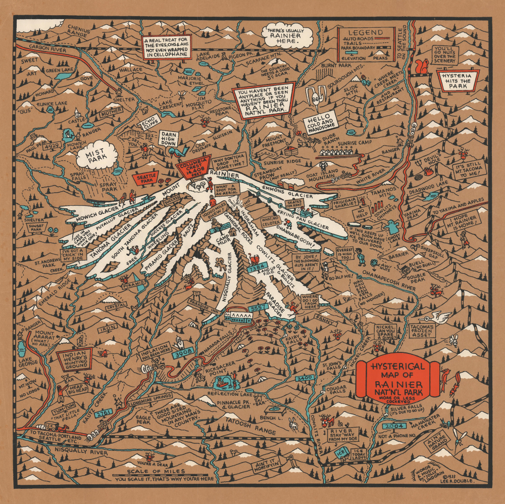

Title
Hysterical Map of Rainier Nat'n'l Park More or Less Cockeyed.
1933 (dated) 19.25 x 19.25 in (48.895 x 48.895 cm)
1933 (dated) 19.25 x 19.25 in (48.895 x 48.895 cm)
Description
FOR THE ORIGINAL ANTIQUE MAP, WITH HISTORICAL ANALYSIS, CLICK HERE.
Digital Map Information
Geographicus maintains an archive of high-resolution rare map scans. We scan our maps at 300 DPI or higher, with newer images being 600 DPI, (either TIFF or JPEG, depending on when the scan was done) which is most cases in suitable for enlargement and printing.
Delivery
Once you purchase our digital scan service, you will receive a download link via email - usually within seconds. Digital orders are delivered as ZIP files, an industry standard file compression protocol that any computer should be able to unpack. Some of our files are very large, and can take some time to download. Most files are saved into your computer's 'Downloads' folder. All delivery is electronic. No physical product is shipped.
Credit and Scope of Use
You can use your digial image any way you want! Our digital images are unrestricted by copyright and can be used, modified, and published freely. The textual description that accompanies the original antique map is not included in the sale of digital images and remains protected by copyright. That said, we put significant care and effort into scanning and editing these maps, and we’d appreciate a credit when possible. Should you wish to credit us, please use the following credit line:
Courtesy of Geographicus Rare Antique Maps (https://www.geographicus.com).
How Large Can I Print?
In general, at 300 DPI, you should at least be able to double the size of the actual image, more so with our 600 DPI images. So, if the original was 10 x 12 inches, you can print at 20 x 24 inches, without quality loss. If your display requirements can accommodate some loss in image quality, you can make it even larger. That being said, no quality of scan will allow you to blow up at 10 x 12 inch map to wall size without significant quality loss. For more information, it is best consult a printer or reprographics specialist.
Refunds
If the high resolution image you ordered is unavailable, we will fully refund your purchase. Otherwise, digital images scans are a service, not a tangible product, and cannot be returned or refunded once the download link is used.
Cartographer S
Adolph Lindenkohl (March 6, 1833 – June 22, 1904) was a German-American cartographer and draughtsman active in the United States during the second part of the 19th century. Lindenkohl was born in Niederkaufungen, Hesse Cassel, Germany. He was educated at the Realschule and later at the Poytechnische Schule, both in Cassel. After graduating in 1852 he emigrated to the United States where, for 2 years, he taught mathematics before taking a position with the United States Coast Survey. Lindenkhol served as a topographer in the Union Army during the American Civil War, translating Coast Survey methodology and technique to land-side surveys for military use. This experience he later translated to other projects, such as the compilation of the first specific map of Alaska as part of the United States (1867). Lindenkohl was a member of the American Association for the Advancement of Science, the Washington Academy of Sciences, the Philosophical Society of Washington and the National Geographic Society. He retained his position with the Coast Survey until his death in 1904. More by this mapmaker...
Leon Lionelle Richard Double (Lee Double; June 22, 1897 - December 16, 1955) was a Seattle, Washington-based businessman, advertising agent, and sometime publisher. Double was born in Morton, Minnesota. He served in the army during World War I (1914 - 1918) with the 26th Company, 166th Depot Brigade. He was president of the American Advertising Federation Seattle from 1931 - 32. As far as cartography goes, Double was an early partner of the Lindgren Brothers and copyrighted four of their earliest 'Slighly Cockeyed Hysterical Maps': Eastern Washington County, Puget Sound County, Mount Rainier, and Olympic Peninsula and Puget Sound Country. Learn More...